Mississippi river meander belt
These maps were made by Harold Fisk for the Army Corp of Engineers in 1944.
Read MoreMaps of the US
These maps were made by Harold Fisk for the Army Corp of Engineers in 1944.
Read More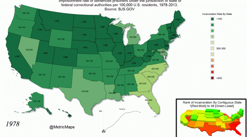
The U.S. has the largest prison population in the world and the highest per-capita incarceration rate. There were 655 people
Read MoreWhat is your state the worst at? Alabama: Stroke Alaska: Suicide Arizona: Alcoholism Arkansas: Worst credit score California: Air pollution
Read MoreTallest buildings by state (feet) Alabama – RSA Battle House Tower (745) Alaska – Conoco-Phillips Building (296) Arizona – Chase
Read MoreWhat every U.S. State is best at: Alabama – Most concealed carry licenses Alaska – Most pilots per capita Arizona
Read MoreThe Signature Food Alabama – BBQ Alaska – King Crab Arizona – Mexican Arkansas – Meth cookies California – In-N-Out
Read MoreImmigration rate, relative to total population of sending country (rates per thousand) based on 2005 population, U.S. Census.
Read MoreTemperate deciduous forests are found in middle latitudes with temperate climates. Deciduous means that the trees in this forest change
Read More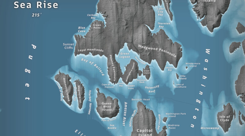
What happens to Seattle when 66 meters of water flood Puget Sound? Jeffrey Linn used LiDAR elevation data to map the city as an archipelago, where Capitol Hill becomes “Capitol Island” and the Space Needle turns into the “Sea Needle.” He created two versions with different cartographic styles.
Read MoreData from satellite sensors show that during the Northern Hemisphere’s growing season, the Midwest region of the United States boasts
Read More