Antarctica is an amazing continent that holds many records. Contrary to popular belief, Asia is not the world’s highest continent—Antarctica is, boasting an average surface elevation of around 2,200 meters (7,200 feet). This extreme elevation is a result of thick ice rather than underlying mountains. Antarctica is also the coldest and driest continent on Earth. At Vostok Station, located in the East Antarctic interior, the temperature plummeted to a record-breaking−89.2°C (−128.6°F) on 21 July 1983 —a feat unmatched by any other weather station. Vostok sits roughly 3,400 metres (11,200 feet) above sea level, surrounded by an ice sheet that averages over 2 kilometres (1.2 miles) deep. In Terre Adélie, the ice reaches an astonishing maximum thickness of 4,776 metres (15,670 feet). Furthermore, due to distortion on standard maps, Antarctica is much larger than most people realize.
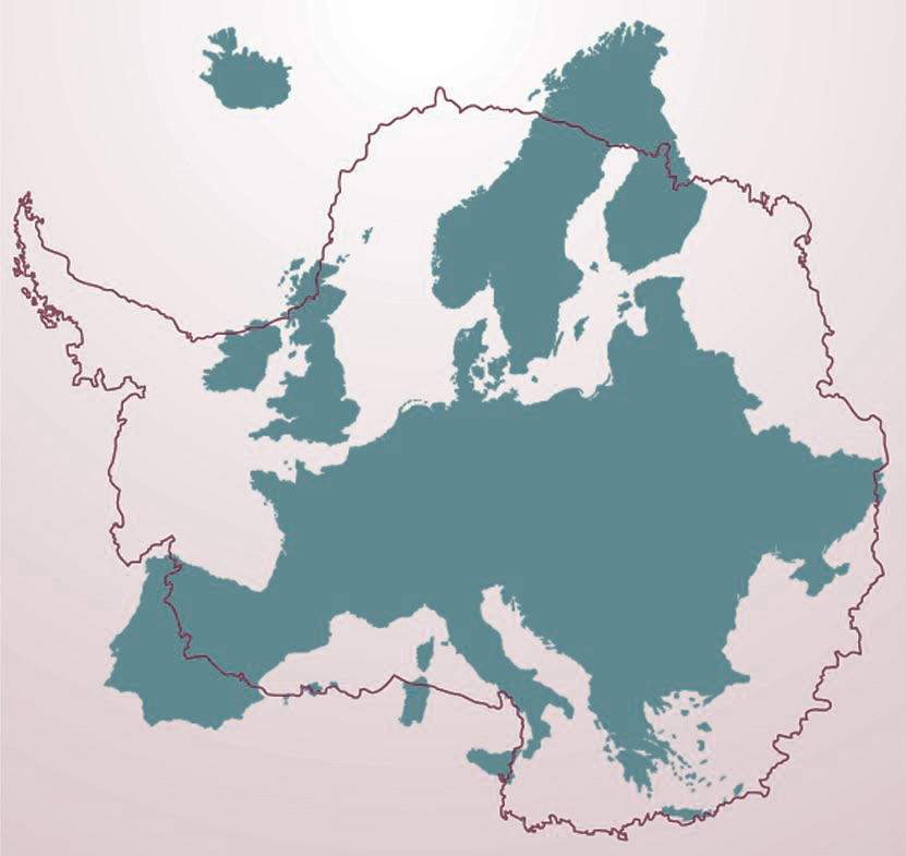
Antarctica covers 14.2 million square kilometres (5.5 million square miles), with its permanent ice shelves included. By comparison, Canada spans 9.98 million square kilometres (3.85 million square miles), while the United States encompasses 9.83 million square kilometres (3.80 million square miles)—making both nations significantly smaller than the frozen continent. Even Europe, which is divided across fifty-plus countries and totals about 10.18 million square kilometres (3.93 million square miles), falls short. Despite holding 745 million people, Europe is still physically smaller than an icy landmass with no permanent population. Only Russia beats them all, dominating the map at 17.1 million square kilometres (6.60 million square miles).
Country / Region
Total Area (km²)
Total Area (mi²)
Antarctica
14,200,000
5,482,651
Russia
17,098,242
6,601,665
Canada
9,984,670
3,855,101
China
9,706,961
3,747,877
United States
9,372,610
3,618,783
Brazil
8,515,767
3,287,955
Australia
7,692,024
2,969,906
Europe (continent)
10,186,000
3,932,836
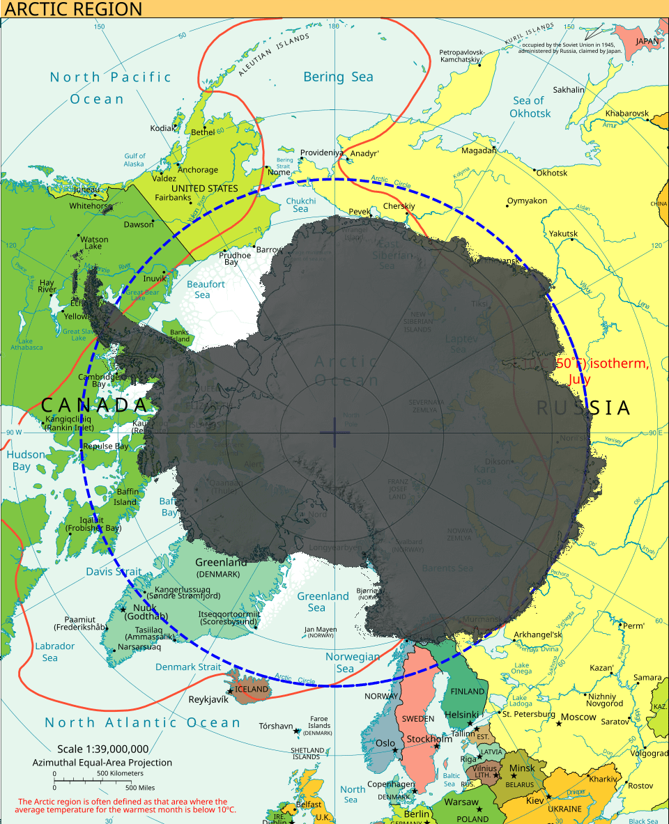
The map below, created by Reddit user Extreme-Shopping74, shows the South Pole over the North Pole.
The Arctic region is often defined as that area where the average temperature for the warmest month is below 10°С (50°F)
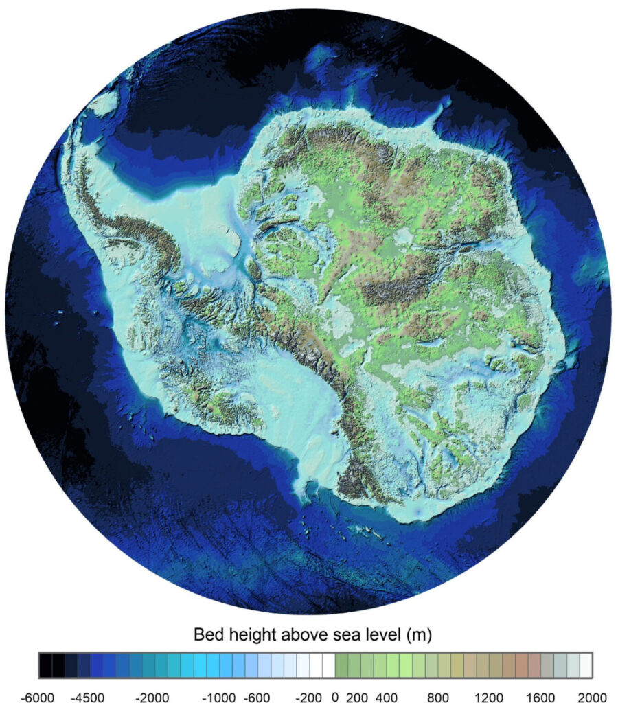
Under the ice, East Antarctica has buried mountain ranges. The Gamburtsev Mountains, in the interior, are completely submerged. West Antarctica is a different case. The bedrock there is largely below sea level. Ice is the only reason it is land at all. Denman Canyon, in the east, has been measured at 3.5 kilometres (2.2 miles) below sea level. No known point on any continental plate goes deeper. The official 14.2 million km² total counts the ice shelves along the coast. The bedrock area without them is around 12.3 million km² (4.8 million mi²). Still larger than every country except Russia.
The map below, created by the British Antarctic Survey, shows the landscape beneath Antarctica’s ice sheet.
About 61% of all the fresh water on Earth is frozen in Antarctic ice. The total volume is around 27 million cubic kilometres (6.5 million cubic miles). If this entire volume were to melt, global sea levels would rise by approximately 58 metres (190 feet), completely submerging the majority of the world’s coastal cities.