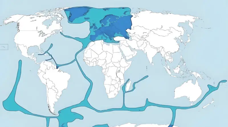
Skip to content
Vivid Maps Logo

Vivid Maps

Maps that explain the World


  • Atlases
  • Map Posters
  • Scratch Maps
  • Globes

Political maps

Political Maps show governmental and administrative borders of countries, provinces, states, and counties, the location of major cities, and other political units.

Democracy Index 2017
Political maps 

Democracy Index (2017)

February 1, 2018 Alex 0 Comments Maps of world

In the 2017 Democracy Index, the average global score fell from 5.52 in 2016 to 5.48 (on a scale of

Read more
Views of the United States
Political maps 

Changing views of the US in the EU (2016 – 2017)

January 16, 2018January 16, 2018 Alex 0 Comments EU, Europe, United States

Percentage point change in those who held a positive view of the United States. Reddit user bezzieford, Data: Eurobarometer 2017

Read more
US friends
Political maps 

U.S. friends and enemies according to the American People (2017)

January 15, 2018January 15, 2018 Alex 2 Comments Maps of world, United States

Who Americans consider their allies, friends, and enemies (YouGov, 2017). Reddit user: anonymous-t-

Read more
Political maps 

Political evolution of U.S. senate (1789 – 2018)

January 12, 2018January 12, 2018 Alex 0 Comments United States

The video below showing history of U.S. Senate, how they switched from party to party from 1789 till 2018. All

Read more
Political maps 

If there was a referendum on the Northern Ireland border…

January 8, 2018January 8, 2018 Alex 1 Comment Ireland, UK

If there was a referendum on the Northern Ireland border tomorrow I would vote for Northern Ireland to join the

Read more
Flags of the World
Political maps 

The uniqueness of the flags visualized

December 17, 2017September 7, 2020 Alex 0 Comments flags, Maps of world

An international flag of every country symbolizes a nation’s brave sacrifices, it expresses its vision, spirit, culture, religion, and history; and instills pride and solidarity among citizens. But most eminently, it’s the identification of every nation and its citizens.

Read more
Political maps 

The last time a stated voted for a Democratic candidate for U.S. senate

December 14, 2017December 27, 2017 Alex 0 Comments United States

Reddit user: Shitmemery Only four states haven’t elected a Democrat in the last ~40 years: -The most recent Democrat to

Read more
Political maps 

Map of most advanced education degrees of American Governors and Canadian First Ministers

November 28, 2017December 27, 2017 Alex 0 Comments Canada, North America, United States

SaxManSteve The most popular advanced education degrees among the American Governors and Canadian First Ministers: • Law – 25 states/provinces

Read more
Political maps 

Map of first higher education degrees of European country leaders

November 23, 2017December 27, 2017 Alex 0 Comments Europe

https://www.reddit.com/user/coneyislandimgur The most popular first higher education among the leaders of European countries: • Law – 16 countries (Belgium, Bosnia

Read more
Infographics Political maps 

Women in politics (2017)

November 20, 2017December 27, 2017 Alex 0 Comments

The color coding of the countries reflects the percentage of women in unicameral parliaments or in the lower house of

Read more
Page 5 of 50« First«...34567...102030...»Last »

Advertisement

Find Us On Facebook

Vivid Maps

Trending now

  • Map of Africa river basins
    Rivers
  • Palms in the United States
    Environment maps
  • Great Lakes
    Lakes
  • Largest Ancestry in the United States
    Ethnic maps
  • Mapping

Advertisement


Globe drinks cabinets · Board games · Monopoly · Map-based strategy board games

Vivid Maps Tools

– Find cities with a similar climate
– Find cities with a similar climate (2050)
– How hot cities could be in 2050
– The U.S. Population Lines
– Convert Latitude/Longitude

– About

Copyright © 2021 Vivid Maps. All rights reserved.