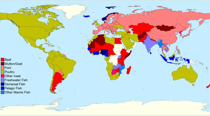
Skip to content
Vivid Maps Logo

  • Atlases
  • Map Posters
  • Scratch Maps
  • Globes
  • Videos
Dissection of Germany mapped
Old maps
May 28, 2018 Alex

The 1941 Map That Proposed Erasing Germany

A Newark businessman’s 1941 book included a shocking map that divided Germany among neighboring countries. The Nazis turned this obscure proposal into powerful propaganda.

Read More
Maps of World ReligionsNewsVivid maps
May 25, 2018 Alex

Religious Diversity Across America: A 120-Year Journey

Follow the fascinating transformation of America’s religious landscape through detailed county-level maps spanning 120 years. Using historical data and modern visualization techniques, these maps reveal the changing patterns of religious diversity across the United States.

Read More
Italy: Panoramic view
Old maps
May 24, 2018 Alex

A Bird’s Eye View of Italy: The Alps-to-Africa Panorama from the 1850s

An extraordinary 19th-century panoramic illustration presents Italy from an impossible vantage point – as if viewed from high above the Alps, with the entire peninsula and Mediterranean Sea stretching toward the African continent.

Read More
The Evolution of Metros in China and Taiwan Mapped
Transport
May 23, 2018 Alex

The Evolution of Metros in China and Taiwan (1990 – 2020): A 30-Year Transportation Revolution

China’s metro development story is remarkable – from Beijing’s first line in 1969 to becoming home to the world’s longest subway networks. Here’s how it happened..

Read More
The New York City Subway Rental Map
Real estate
May 23, 2018 Alex

The NYC Subway Rental Map

Taking a closer look at how New York City’s subway system shapes rental prices across neighborhoods, revealing unexpected patterns and money-saving opportunities for those willing to walk a few extra blocks.

Read More
ClimateNewsVivid maps
May 22, 2018 Alex

What is the largest country in the world based on the most suitable land area for human habitation?

By analyzing climate conditions and settlement patterns worldwide, this study shows which countries offer the most land area suitable for comfortable human habitation, with Brazil leading the list.

Read More
Number of offences per 10,000 drivers
Laws
May 21, 2018 Alex

The worst drivers in the United Kingdom

From police force areas to regional statistics, this analysis shows how driving offenses have evolved across the UK, with striking differences between urban and rural areas.

Read More
The Progress of the Union Armies
Old maps
May 20, 2018 Alex

A Powerful Message in Black and White: The 1863 “Progress of the Union Armies” Broadside

Analysis of a remarkable 1863 Civil War propaganda broadside featuring an influential persuasive map that demonstrated Union territorial gains to boost Northern morale during a pivotal moment in the conflict.

Read More
Sociology
May 20, 2018 Alex

Gun ownership in the United States

An in-depth look at America’s unique relationship with firearms, analyzing ownership patterns across states and comparing them to global statistics. With over 393 million civilian-owned firearms, the US leads the world in gun ownership – but the rates vary dramatically by state.

Read More
Medeival trade routes
Historical Maps
May 19, 2018 Alex

Medieval Trade Networks

Medieval trade networks were a crucial aspect of the global economy during the Middle Ages, connecting different regions of the

Read More
Page 104 of 679« First«...102030...102103104105106...110120130...»Last »

Trending now

  • nglish names and Latin translations
    U.S. State Names Translated into Latin
  • Human phenotypes in Europe
    Human Phenotypes Mapped

Related Products

Push pin maps · Globe drinks cabinets · Maps of the United States · Board games · Monopoly · Map-based strategy board games · History Board Games · Coloring Books · Handheld GPS · GPS Watches · GPS Trackers

Vivid Maps Tools

· Convert Latitude/Longitude
· Elevation Finder
· Distance Calculator
· Kilometers to Miles Converter
· Kilograms to Pounds Converter
· Liters to Gallons Converter
· Temperature Converter
· Antipodes Map
· Find cities with a similar climate
· Find cities with a similar climate (2050)
· How hot cities could be in 2050
· The U.S. Population Lines

About
Privacy Policy

Copyright © 2026 Vivid Maps. All rights reserved.