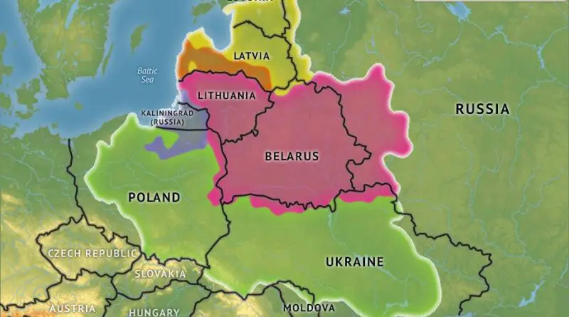
Skip to content
Vivid Maps Logo

  • Atlases
  • Map Posters
  • Scratch Maps
  • Globes
  • Videos
World map of countries based on share of immigrants
DemographyNewsVivid maps

Mapped: Countries With the Lowest Percentage of Immigrants

June 18, 2025 Alex
United States border elevation maped
Environment mapsNewsPolitical mapsVivid maps

United States Border Walls

May 21, 2025 Alex
Cash in the banks by U.S. state mapped
Economic mapsNewsVivid maps

States Where Americans Have the Most Cash in the Bank

May 5, 2025 Alex
Countries wealthier than the global average mapped
Economic maps

Which Countries Are Wealthier Than the Global Average?

July 27, 2025 Alex
Siesta in world countries mapped
Cultural cartography

Siesta Nations: A Map of Midday Rest Traditions Around the World

July 19, 2025 Alex
Difference between male and female BMI by country mapped
Health

Who Has Higher BMI: Men or Women?

June 25, 2025 Alex
World map of countries based on share of immigrants
DemographyNewsVivid maps

Mapped: Countries With the Lowest Percentage of Immigrants

June 18, 2025 Alex
World map: Climate one year after nuclear war
ClimateScience
October 17, 2017 Alex

The Global Impact of a Nuclear Winter

Discover the potential global impact of a nuclear winter through detailed world maps showing temperature and precipitation changes, and the devastating effects on growing seasons. Learn about the catastrophic consequences on climate and agriculture.

Read More
Interactive mapsNewsResourcesWater
October 17, 2017 Alex

Your Water is Owned by Who?

The Environmental Protection Agency tracks 147,354 individual water systems in the U.S. – 81% of those systems are publicly run

Read More
Historical Maps
October 16, 2017 Alex

The world map (2000 BC)

The Ancient Near East marks the metamorphosis from the Middle to the Late Bronze Age. The Ancient Near East marks the metamorphosis from the Middle to the Late Bronze Age. The Babylonians created a mathematical system based on units of 60. They also split a circle into 360 units.

Read More
Historical MapsNews
October 16, 2017 Alex

The Netherlands: The wars of independence (1648)

The colored area represents the Netherlands in the time of Charles V. The light green and the dark green distinguish

Read More
NewsTravel
October 15, 2017 Alex

Jean Beliveau’s pedestrian circumnavigation route

Jean Beliveau’s Jean Béliveau (born August 18, 1955) is a Quebec walker who traveled around the world in 11 years,

Read More
Interactive mapsMigration maps
October 15, 2017 Alex

Migration to and from London (2013 – 2016)

Visualization of the migration flows data for areas of the England to and from London. election-data.co.uk

Read More
Historical MapsVideo
October 15, 2017 Alex

The History of Scandinavia: Every Year

The video below shows the entire history of Northern Europe from the formation of the earliest state-level societies to 2017.

Read More
Mapping Stereotypes
October 14, 2017 Alex

Stereotypical map of the Ireland’s counties

Source: dynamitestudio.ie UK counties:AntrimArmaghDerryDownFermanaghTyrone Ireland’s counties:Carlow –Cavan – Miles awayClare – RocksCork – People’s republicDonegal – Daniel O’DonnellDublin – IkeaGalway

Read More
Humor
October 14, 2017 Alex

XKCD on the design of U.S. state borders

XKCD, is a webcomic created by American author Randall Munroe. The comic’s tagline describes it as “A webcomic of romance, sarcasm,

Read More
Languages
October 14, 2017 Alex

Languages of North America, before European colonization

There are approximately 296 spoken indigenous languages north of Mexico, 269 of which are grouped into 29 families. The Na-Dené, Algic, and Uto-Aztecan families are the largest in terms of several languages.

Read More
Page 131 of 672« First«...102030...129130131132133...140150160...»Last »

Trending now

  • Gulag Archipelago
    The Gulag Archipelago (The Soviet forced labor camp system)
  • How Buddhism Spread Across Asia: Trade, Teaching, and Time

Related Products

Push pin maps · Globe drinks cabinets · Maps of the United States · Board games · Monopoly · Map-based strategy board games · History Board Games · Coloring Books · Handheld GPS · GPS Watches · GPS Trackers

Vivid Maps Tools

· Convert Latitude/Longitude
· Elevation Finder
· Distance Calculator
· Kilometers to Miles Converter
· Kilograms to Pounds Converter
· Liters to Gallons Converter
· Temperature Converter
· Find cities with a similar climate
· Find cities with a similar climate (2050)
· How hot cities could be in 2050
· The U.S. Population Lines

About
Privacy Policy

Copyright © 2025 Vivid Maps. All rights reserved.