Skip to content
Vivid Maps Logo

  • Atlases
  • Map Posters
  • Scratch Maps
  • Globes
  • Videos
Cultural cartography
July 16, 2017 Alex

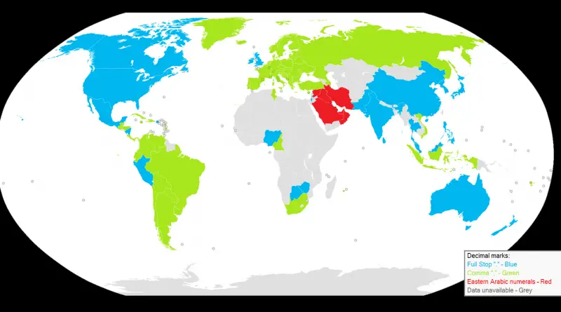
Decimal marks around the world

A decimal separator is a symbol that separates the integer part from the fractional part of a number written in decimal form. Different nations choose different characters for use as a separator. The choice of the symbol also affects the symbol selection for the thousands separator used in digit grouping.

Read More
MexicoSlider
July 16, 2017 Alex

Tacography, a map of different tacos from around Mexico (Spanish)

Read More
Ethnic mapsSize comparison maps
July 16, 2017 Alex

What thetruesize.com really does

Using thetruesize.com it is apparent that Argentina, compared to Europe, is larger than many had thought. Especially the nothern part

Read More
Economic mapsInteractive mapsInternet
July 16, 2017 Alex

Areas in which our stumbling community has collected data samples

The interactive map below shows general areas for which we have data samples. It does not show the locations of

Read More
Mapping StereotypesRelief maps
July 16, 2017 Alex

Relief map of the British Isles

Reddit user: AJgloe

Read More
Mapping StereotypesOld maps
July 15, 2017 Alex

Japanese Pictorial World Map, 1932

Japanese pictoral map, showing what were the national stereotypes at the time

Read More
Historic Italy housing building mapped
Real estate
July 15, 2017 Alex

Italy’s Housing Landscape: The Pre- and Post-1961 Building Boom

A striking visualization reveals the patterns of Italy’s residential development, showing which communities preserved their historic buildings and which underwent massive modern expansion after 1961 – a key year that marked the peak of Italy’s economic miracle.

Read More
Historical Maps
July 15, 2017 Alex

Territory claimed by Spain and Portugal due to Treaties of Tordesillas and Zaragoza

Reddit user: ThorPL123

Read More
World
July 15, 2017 Alex

Humans in Antarctica

Credit: Seweryn Szeliga Antarctica has no permanent residents, although it contains research stations and field camps that are staffed seasonally

Read More
CartogramsCultural cartographyEnergy
July 15, 2017 Alex

Map showing the relative size of each of the United States if based on Electrical energy sold for light and power (1921)

“Relative size of each of the United States if based on electrical energy sold for light and power in 1921

Read More
Page 172 of 679« First«...102030...170171172173174...180190200...»Last »

Trending now

  • Decolonisation of Africa mapped
    Atlas of the colonization and decolonization of Africa
  • Human phenotypes in Europe
    Human Phenotypes Mapped

Related Products

Push pin maps · Globe drinks cabinets · Maps of the United States · Board games · Monopoly · Map-based strategy board games · History Board Games · Coloring Books · Handheld GPS · GPS Watches · GPS Trackers

Vivid Maps Tools

· Convert Latitude/Longitude
· Elevation Finder
· Distance Calculator
· Kilometers to Miles Converter
· Kilograms to Pounds Converter
· Liters to Gallons Converter
· Temperature Converter
· Antipodes Map
· Find cities with a similar climate
· Find cities with a similar climate (2050)
· How hot cities could be in 2050
· The U.S. Population Lines

About
Privacy Policy

Copyright © 2026 Vivid Maps. All rights reserved.