
Skip to content
VividMaps

  • Atlases
  • Map Posters
  • Scratch Maps
  • Globes
  • Videos
World
May 15, 2015 Alex

Fascinating Relief Map of the Earth, showing exaggerated mountain ranges

Here’s Japan, Korea, Russia and China Alaska Western United States and Mexico South America Eastern Europe Northern Europe Western Europe

Read more: Fascinating Relief Map of the Earth, showing exaggerated mountain ranges →
Mapping Health
May 15, 2015 Alex

The Most distinctive causes of death by state (2001-2010)

Most Distinctive Causes of Death A. Tuberculosis B. Meningococcal infection C. Septicemia D. Syphilis E. Human immunodeficiency virus F. Other

Read more: The Most distinctive causes of death by state (2001-2010) →
Migration mapsPopulation
May 15, 2015 Alex

Percent Asian ancestry in North America

Archaeological evidence shows that people have been in the Americas for at least over 12 thousand years. The population of

Read more: Percent Asian ancestry in North America →
CartogramsPopulation
May 15, 2015 Alex

Territories of the US, sized by population

144 largest U.S. counties have population: 159,524,138 (50.03% of total population). 2,998 smallest U.S. counteis have same population – 159,332,918

Read more: Territories of the US, sized by population →
DemographyHistorical Maps
May 15, 2015 Alex

Animated history of US county boundaries

Thirty-second animation of the changes in United States historical county boundaries (1629 – 2000). Historical state and territorial boundaries are

Read more: Animated history of US county boundaries →
Historical Maps
May 14, 2015 Alex

All the land under European control in 1922

The zenith of western imperialism. Political map of 1922 The British Empire was at its peak The largest and most

Read more: All the land under European control in 1922 →
InternetServices
May 13, 2015 Alex

Clean Ride Mapper

Click on the map to define the origin and destination of your trip. In addition to the shortest route, two

Read more: Clean Ride Mapper →
Political maps
May 11, 2015 Alex

Global Peace Index

Global Peace Index measures the relative position of nations and regions peacefulness. The Global Peace Index gauges global peace using

Read more: Global Peace Index →
Infographics
May 11, 2015 Alex

Regions of Alaska

1. FAR NORTH! Geography: Larger than Utah, Indiana, and Maryland combined. Or a bit larger than Germany. Mostly uninhabited tundra,

Read more: Regions of Alaska →
Languages
May 10, 2015 Alex

Probability that any two people of a country selected at random would have different mother tongues (Greenberg’s Diversity Index)

Greenberg’s Diversity Index is the probability that two people selected from the population at random will have different languages. Index

Read more: Probability that any two people of a country selected at random would have different mother tongues (Greenberg’s Diversity Index) →
Cultural cartography
May 10, 2015 Alex

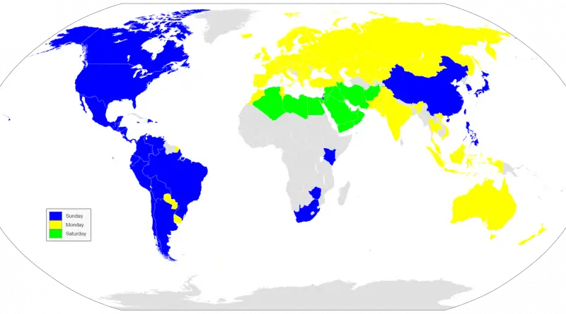
First day of the week in different countries

Around half of the world’s population begins its week on Sunday. Monday is the first day of the week for the other half. Almost all countries in the Americas start their week on Sunday, while countries in Europe and Oceania overwhelmingly begin on Monday.

Read more: First day of the week in different countries →
CartogramsDemography
May 10, 2015 Alex

Child Under-Five Deaths by Country,representing 6.3 million deaths

Figures rounded to the nearest ten thousand. The map below represents 6.3 million deaths. India has the highest number of

Read more: Child Under-Five Deaths by Country,representing 6.3 million deaths →
Environment mapsWorld
May 10, 2015 Alex

Climates classification by Wincenty Okołowicz

Wincenty Okołowicz was a Polish geographer and climatologist. He is best known as the author of the World’s climatic zones

Read more: Climates classification by Wincenty Okołowicz →
Page 504 of 521« First«...500501502503504505506507508...»Last »

Trending now

  • Language Families Spoken in AfricaOct 21, 2017
  • United States Map: Native Americans
    Native Americans in the United States: A Living LegacyNov 5, 2024
  • Largest Ancestry in the United States
    Largest Ancestry by U.S. CountyMar 23, 2019

Related Products

  • Push pin maps
  • Globe drinks cabinets
  • Maps of the United States
  • Board games
  • Monopoly
  • Map-based strategy board games
  • History Board Games
  • Coloring Books
  • Handheld GPS
  • GPS Watches
  • GPS Trackers

Vivid Maps Tools

  • Convert Latitude/Longitude
  • Elevation Finder
  • Distance Calculator
  • Kilometers to Miles Distance & Length Converter
  • Weight Converter
  • Volume Converter
  • Daylight Comparison
  • Time Zone Converter
  • Antipodes Map
  • Find cities with a similar climate
  • Find cities with a similar climate (2050)
  • How hot cities could be in 2050
  • The U.S. Population Lines

Stay connected

Get the latest maps, insights and updates delivered to your inbox.

Unsubscribe anytime.

VividMaps

Maps that explain the world.

Beautiful, data-rich maps to help you understand our world — its people, places and connections.

Explore

World map World atlas Map posters Globes

Company

About Privacy Contact

Stay connected

Follow us for the latest maps, insights and updates.

Independent WebsiteVirusScanner trust report for vividmaps.com
© 2026 Vivid Maps. All rights reserved.
A more connected world