


What Seattle & LA would look like if all the world’s polar ice melted
Islands of Seattle: Map based on 215′ sea level rise. Los Angeles Bay: Map based on 260′ sea level rise.
Read More


Islands of Seattle: Map based on 215′ sea level rise. Los Angeles Bay: Map based on 260′ sea level rise.
Read MoreWe may live in a world defined by invisible meta-data and the Cloud, but the roughly 3×5 inch paper booklet
Read MoreData from satellite sensors show that during the Northern Hemisphere’s growing season, the Midwest region of the United States boasts
Read MoreUS economic growth in 2015 was strongest since 2005 (18.04 trillion USD (56,207.04 per capita)).
Read MoreTop 15 Largest Border Differences in USD (GDP per capita) Richer Country vs Poorer Country Qatar (102,100) – Saudi Arabia
Read More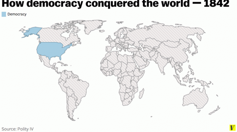
Democracy is a system of government in which the citizens exercise power directly or elect representatives from among themselves
Read Moreuman skin color varies from the darkest brown to the lightest tints. Divergence induces distinctions in skin color among people in pigmentation, which comes from genetics and exposure to sunlight. Disparities across populations developed through natural selection because of environmental differences and regulated the biochemical impacts of ultraviolet radiation infiltrating the skin.
Read MorePlant Hardiness Zones for Canada. Related post: – Find cities with a similar climate
Read MoreUnited States, Canada, Germany, Norway, Netherlands, Switzerland, Australia and New Zealand have the highest human development index score.
Read More– Nearly one in every five deaths of children under the age of five worldwide is due to a water-related
Read More