Trade Routes of the Roman Empire
The roads and routes constructed and developed by the Roman bound all manner of peoples together, made possible the intermingling
Read more: Trade Routes of the Roman Empire
Historical maps showing territorial changes of countries and historical events of the past.
The roads and routes constructed and developed by the Roman bound all manner of peoples together, made possible the intermingling
Read more: Trade Routes of the Roman Empire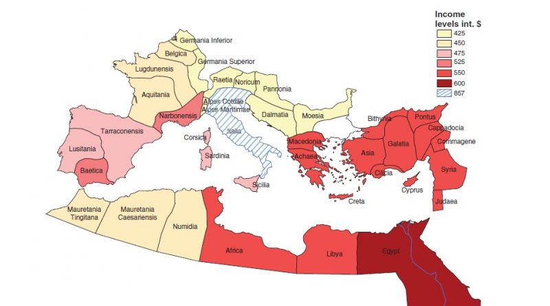
Economic historians differ in their estimates of the gross domestic product of the Roman economy. Per capita income in the provinces of the Roman Empire range from $425 to $867 (2000 US dollar). The GDP per capita of Italy is valued at approximately 50 percent higher than in the rest of the Roman Empire.
Read more: Per capita income in the provinces of the Roman EmpireWorld War II was the deadliest military conflict in the history of humankind (85 million people were killed). The USSR
Read more: World War II casualties as a percentage of the populationt different times, Germany had incorporated Austria, Belgium, Czechia, the Netherlands, Northern Italy, Liechtenstein, Poland, Switzerland, Luxembourg, Slovenia, and Western Poland. The German colonial empire began developing in 1883 and ended in 1919 following WWI when its colonies were seized and given to the victors
Read more: All territories ever of Germany“The World: Colonial possessions and commercial highways (1910)” Portugal becomes the 1st republican nation in the century after the revolution,
Read more: 1910 World mapThe map of Europe changed considerably after the WWI. Germany lost about 10 percent of its territory to its neighbors.
Read more: Present days borders over 1937’s countriesAnthropomorphic maps of European countries. The maps below were printed in ‘Geographical Fun’, a beautiful atlas of parody maps of
Read more: Pictorial atlas (1868)Finland bordering the Baltic Sea, Gulf of Bothnia, and the Gulf of Finland, between Norway to the north, Sweden to
Read more: Border changes in Finland
From 1778 to 1871, the U.S. signed 368 treaties with different indigenous tribes across North America. These treaties were based on the fundamental concept that each Native American tribe was a sovereign nation. But as white immigrants started moving onto Indigenous American lands, this concept confronted the rigid pace of westward expansion. As a result, many promises were broken by the U.S. government.
Read more: Indian land cessions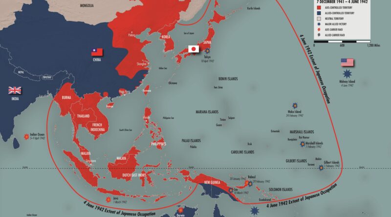
From the middle of the nineteenth century, Japan began to see a colonial empire on the Western-type as one of the traits of state power and political modernity.
Read more: Empire of Japan at its heightToday the Vatican City State is just a new name for the Papal States. Italy never occupied the territory that
Read more: Italy in 1796From 1860 to 1870, the South of the U.S. demonstrated considerable homogeneity in land value gains across specific regions, such as urban areas and river counties. On average, the most significant increases occurred in the slave-dense areas such as the Mississippi Delta and Cotton Belt.
Read more: The Changing Value of Land (1860 – 1870)
After WWI four empires collapsed (The German Empire, the Austro-Hungarian Empire, the Ottoman Empire, Russian Empire). The collapse of these empires led to the formation of multiple new countries, the most important of which included Poland, Yugoslavia, and Czechoslovakia. Other European countries like France, Italy, and Romania increased in size.
Read more: Europe before and after the First World War