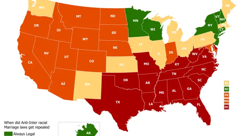
Atlas of The Changing Borders of Europe
The history of the European continent is mind-blowing complicated. That’s why the borders of many European countries have changed many times.
Read MoreHistorical maps showing territorial changes of countries and historical events of the past.
The history of the European continent is mind-blowing complicated. That’s why the borders of many European countries have changed many times.
Read MoreMaps have been one of the most significant human creativity for millenary. People have invented and used maps to describe, clarify, and navigate their route within the world. Here is an atlas of the most famous maps, from the prehistoric period to modern times.
Read MoreThe Civil Rights Act of 1964 is a milestone in civil rights and labor law in the U.S. that bans discrimination based on race, color, national origin, faith, and sex. It forbids the unequal use of voter registration necessities and racial discrimination in schools, work, and public services.
Read MoreThe first Portuguese settlement was founded after the signing “Tordesilhas Treat” in 1532. Colonization began in 1534 when King John III of Portugal split the territory into the fifteen private and autonomous Captaincy Colonies of Brazil.
Read MoreAtlantropa was a gigantic engineering and colonization idea designed by the German architect Herman Sörgel to unite the continents of Europe and Africa through the partial evaporation of the Mediterranean Sea.
Read MoreThe breakdown of Russia formed Poland, Finland, Estonia, Latvia Lithuania. The Austro-Hungaria separated into Austria, Czechoslovakia, Hungary, and Yugoslavia. The Ottoman Empire lost much of its territory in the Middle East and southwest Asia. Germany lost considerable territories outside Europe.
Read MoreCount of Aranda was ambassador to France when the Thirteen Colonies proclaimed their independence from Great Britain, thus kindling the American Revolution. He was involved in drafting the peace treaty that finished the conflict. In addition, his profound knowledge of history placed him ahead of his time, and he predicted the rise of the U.S. as a world power.
Read MorePamphlets from1920 spread by the Hungarian Government to foreign locals disagreeing about the Treaty of Trianon. In this way, the Government made an effort to explain what this would converte to if the same thing happened to France, Italy, the United Kingdom, the United States, and the German Empire.
Read MoreVirginia’s territorial claims have evolved significantly over the years, shaping the state’s geographic boundaries and influencing its historical narrative. The origins of Virginia’s territorial claims can be traced back to the early 17th century, when English settlers, led by the Virginia Company, established the Jamestown colony in 1607. The original charter granted by King James I defined Virginia’s boundaries as stretching from the Atlantic Ocean to the Pacific Ocean.
Read MoreBritish colonial shipping lanes covered vast expanses, connecting the British Isles to North America, the Caribbean, South Asia, and the Pacific. Spanish lanes were primarily transatlantic, centered on the Atlantic Ocean and Caribbean. French routes spanned the Atlantic, Indian, and Pacific Oceans, reaching North America, the Caribbean, Southeast Asia, and the South Pacific. Dutch shipping lanes had a global reach, including the Indian and Pacific Oceans, with a strong presence in Southeast Asia and the East Indies.
Read More