The World’s Forests Mapped
A forest is an area of land covered by trees. According to the Food and Agriculture Organization, forests cover some 3.9 billion hectares (or 9.6 billion acres), which is about 30% of the Earth’s land surface.
Read More
A forest is an area of land covered by trees. According to the Food and Agriculture Organization, forests cover some 3.9 billion hectares (or 9.6 billion acres), which is about 30% of the Earth’s land surface.
Read More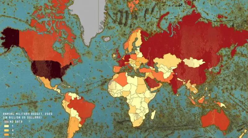
World military expenditure is measured to have been nearly $2 trillion in 2019, the highest level since 1988, and it continues to grow. Global military spending increased in each of the five years from 2015, has declined firmly from 2011 until 2014 following the world financial crisis.
Read More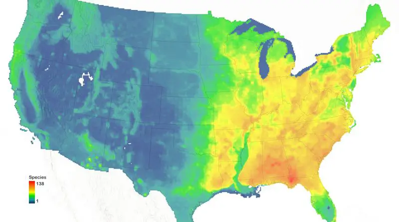
According to the U.S. Forest Service report, more than 640 various species of trees in the United States, 186 of which are endemic. Maps of tree diversity in the U.S. include the total species richness and endemic species of trees.
Read More
Since the U.S. Congress enacted the Fair Housing Act in 1968, wealth amongst white households has significantly increased while wealth in black households has frozen. HowMuch.net took a glance at the data concerning the median income gap within Black and white households in the U.S.
Read More
The Mediterranean Sea at all times played a significant role in the communication of the peoples around it. The world map shows what a unique position the Mediterranean Sea has in the world. It looks like a closed sea, but it offers the main transit routes linking east and west. All this, along with a beautiful climate and abundant nature, has made the Mediterranean region the cradle of world civilization. The maps below show the uniqueness of the Mediterranean region.
Read More
Atlantropa was a gigantic engineering and colonization idea designed by the German architect Herman Sörgel to unite the continents of Europe and Africa through the partial evaporation of the Mediterranean Sea.
Read More
Happiness connects with many life factors: GDP per capita, social support, healthy life expectancy, freedom to make life choices, generosity, and the absence of corruption. Which country is the happiest?
Read More
The maps of the United States show elevation, precipitation, and population density in the style of Joy Division.
Read More
The coronavirus pandemic caused by severe acute respiratory syndrome (COVID-19) was first known in Wuhan (Chinese province Hube) in December 2019. It was identified as a pandemic by the World Health Organization on 11 March 2020.
Read More
If all the ice covering Antarctica, Greenland, (Antarctica would make about 60 meters of sea-level rise, Greenland about 60 meters) and in mountain ice caps around the globe were to melt, sea level would rise about 70 meters (230 feet) and cover all seaside cities.
Read More