State flowers of the contiguous U.S.
Reddit user: WhoIsWardLarson Alabama – Oak-Leaf HydrangeaAlabama – CamelliaAlaska – Alpine Forget-me-notArizona – Saguaro Cactus BlossomArkansas – Apple BlossomCalifornia –
Read MoreMaps of the US
Reddit user: WhoIsWardLarson Alabama – Oak-Leaf HydrangeaAlabama – CamelliaAlaska – Alpine Forget-me-notArizona – Saguaro Cactus BlossomArkansas – Apple BlossomCalifornia –
Read MoreWyoming the most dangerous state for drivers, has reported deaths for every 100,000 people.
Read MoreDespite a warm-temperate climate similar to that of southern Japan, the coastal plain of the southeastern USA is usually described
Read MoreWorst 5 schools: 1. Trinity Downtown Lutheran Church and School (Harris County, Texas)2. East Side Elementary School, P.S. 267 (New
Read MoreItalians have been an integral part of America’s history, from the first waves of immigrants in the late 19th century to vibrant communities today. This post delves into the journey of Italians in America, highlighting where they settled, their contributions, and the spread of the Italian language. We’ll also explore the lives of famous Italians who have shaped American history and provide resources for those interested in learning Italian.
Read MoreCatholics as a percentage of all residents (1890 – 2010) Catholics as a percentage of all residents (2010) Most Catholic States
Read More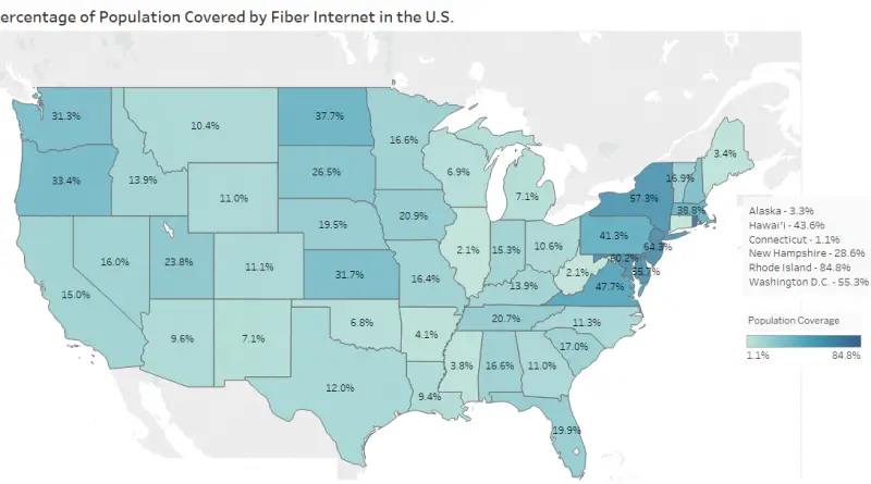
privacyrightsusa.org Some facts: – Broadband coverage in the United States is fairly; widespread if you don’t live more than about
Read MoreRedit user: JohnDoeMonopoly
Read MoreWeek 0 Via self.nfl Week 1 Via self.sfb Week 2 Via self.sfb
Read More
Muslims as a percentage of all residents, 1980 – 2010 YouTube version of the map Muslims as a percentage of
Read More