A day with no metro in Washington
A Day with No Metro: The Metro system shut down for emergency repairs on March 16, 2016. This map visualizes
Read more: A day with no metro in Washington
A Day with No Metro: The Metro system shut down for emergency repairs on March 16, 2016. This map visualizes
Read more: A day with no metro in WashingtonHow every New York City neighborhood voted in the Democratic Primary How every New York City neighborhood voted in
Read more: How Every New York City Neighborhood Voted in the Democratic and Republican Primary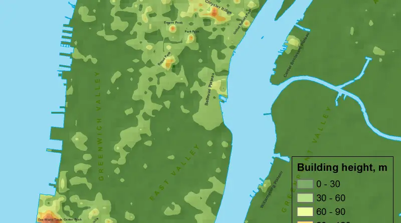
The skyline of Manhattan, New York City, stands as a testament to architectural innovation and urban development. Marked by iconic skyscrapers, the height of buildings in Manhattan is a defining characteristic of the city’s landscape. The island has been a focal point for vertical expansion, with structures reaching impressive heights that not only serve practical purposes but also contribute to the visual identity of the city.
Read more: If Manhattan was a mountain…Related posts: – Countries whose capital is close to the border – Rivers that flow through multiple capitals
Read more: Countries with multiple capitalsMap of Manhattan in 1865 of the original boundaries and waterways of Manhattan.
Read more: Map of Manhattan (1865)As part of Mayor Eric Garcetti’s Clean Streets initiative, the City’s Bureau of Sanitation drove all of LA’s public streets
Read more: The cleanliness of Los Angeles streetsThis study focuses on a few of the most intractable problems that any robust bikeshare network faces: rebalancing stations so
Read more: New York Citi Bike Rebalancing StudyRelated posts: – New York City transit frequency – Yellow Taxi Trips (2015) – TV Shooting Locations in New York
Read more: 8 U.S. State populations that fit into the 5 New York boroughsThis map is not a strict map of Vancouver but a new representation of Vancouver through its building height in
Read more: If downtown Vancouver was a mountain…Inspectors gave failing cleanliness grades to more than 370 miles of streets and alleys in Los Angeles, or about 4%
Read more: Where are L.A.’s dirtiest streets?The world map (top right) is coloured according to month of peak cloudiness (top left). Areas of little seasonality are
Read more: Using clouds to locate threatened species