Global temperature anomalies of 2015
2015 was hottest year in recorded history.
Read more: Global temperature anomalies of 2015
2015 was hottest year in recorded history.
Read more: Global temperature anomalies of 2015The best New York City maps of 2015 – Energy use in NYC’s biggest buildings – Transit Time NYC – Mapping New
Read more: New York City greenhouse gas emissionsThis map shows how much average temperatures have changed and are likely to change by in future. Scroll through the
Read more: Mapping climate change in South AfricaVia thetimes.co.uk
Read more: Coal fired power stationDo pledges require international climate aid? The map shows how most conditional pledges have been made by nations in the
Read more: Explore the world’s climate pledgesUsing statistically modeled maps drawn from satellite data and other sources, U.S. Geological Survey scientists have projected that the near-surface
Read more: USGS projects large loss of Alaska permafrost by 2100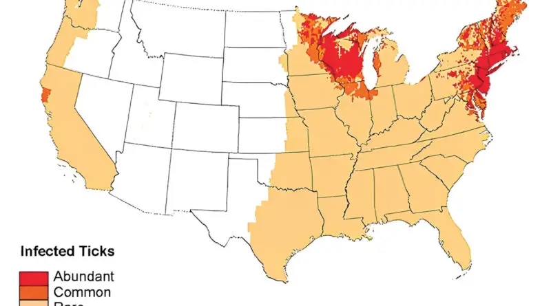
Ticks are parasites, being by feeding on the blood of mammals, birds, and even amphibians. Ticks themselves don’t produce disease, but if a tick is infected with a bacterium or virus, then that pathogen can be transferred within the tick’s bite and cause illness in humans. In the U.S., 9 ticks most often attack humans.
Read more: Geographic distribution of ticks and disease cases in the U.S.Climatecentral.org developed special KML layers corresponding precisely to the elevated global sea surfaces projected to inevitably occur after 2°C or
Read more: Global cities at risk from sea level riseThis is an animated visualization of the startling decline of Arctic Sea Ice, showing the minimum volume reached every September
Read more: Arctic sea ice minimum volumes (1979 – 2015)Measurements tell us that global average sea level is currently rising by about 1 inch per decade. But in an
Read more: States impacted by sea level rise