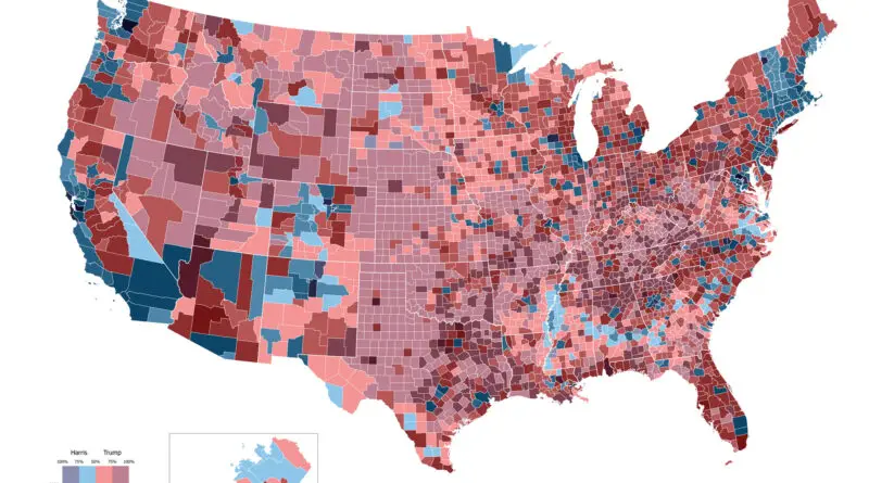
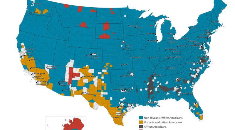
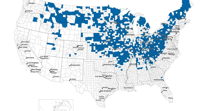
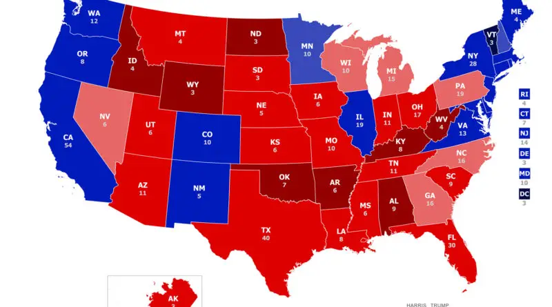
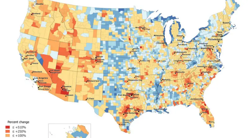
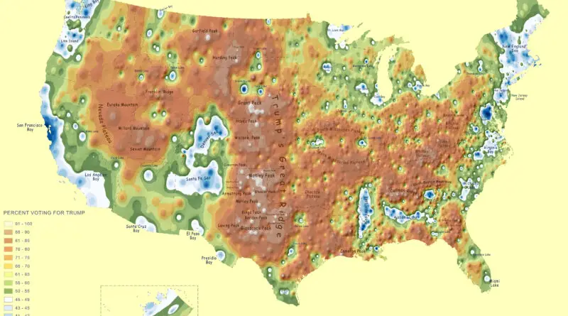
Skip to content
Vivid Maps Logo

Vivid Maps

Maps that explain the World


  • Atlases
  • Map Posters
  • Scratch Maps
  • Globes

Vivid maps

Percent change in Whites Non Hispanic Population
News Population Vivid maps 

Percent Change in White Non-Hispanic Population by U.S. county (1990 – 2017)

September 24, 2018September 24, 2018 Alex 0 Comments United States

The number of non-Hispanic Whites in the U.S. peaked in 2015 (197,8 million). Between 2015 and 2017, the non-Hispanic White

Read more
Demography News Population Vivid maps 

Percent Change in Population by U.S. County (1990 – 2017)

September 19, 2018September 19, 2018 Alex 0 Comments United States

Today the US has a population of 329 million people, making it the 3rd most populous country in the world.

Read more
U.S. Non-Hispanic White Population by County
Animated maps Demography Ethnic maps News Vivid maps 

U.S. Non-Hispanic White Population by County (1990 – 2017)

September 17, 2018January 17, 2020 Alex 0 Comments News, non-Hispanic whites, United States

In 2011, for the first time in United States history, non-Hispanic whites accounted for under half of the births in

Read more
Animated maps Demography News Vivid maps 

U.S. Population Density Mapped

August 23, 2018January 11, 2021 Alex 0 Comments Population, population density, United States

Population density has been monitored for more than 200 years in the U.S. During this time, the number of people living in the U.S. per square mile has grown from 4.5 in 1790 to 87.4 in 2010. Nowadays, the population density in the United States is 94 per square mile.

Read more
Road Density (2000 - 2011)
Animated maps News Transport Vivid maps 

What country has a highest road density?

July 18, 2018January 3, 2021 Alex 0 Comments Maps of world

Road density is the ratio of the length of the country’s total road network to the country’s land area. The

Read more
Maps of World Religions News Vivid maps 

Religious diversity in the United States (1890 – 2010)

May 25, 2018May 25, 2018 Alex 0 Comments United States

The diversity index in this study is based on the Simpson’s Diversity Index, where we rank each county on the

Read more
Percentage of female population dying before the age of 65 (1960 – 2015)
Animated maps Demography Mapping Health Vivid maps 

Percentage of female population dying before the age of 65 (1960 – 2015)

April 9, 2018January 17, 2020 Alex 0 Comments Maps of world, News

Youtube Percentage of the female population died before the age of 65 (2015)   Percentage of female population dying before

Read more
Percentage of male population dying before the age of 65 (2015)
Animated maps Mapping Health News Vivid maps 

Percentage of male population dying before the age of 65 (1960 – 2015)

April 3, 2018January 3, 2021 Alex 0 Comments Maps of world

Youtube Percentage of the male population died before the age of 65 (2015) Percentage of the male population dying before

Read more
News Transport Vivid maps 

American railway stations (Meters above sea level)

March 12, 2018March 12, 2018 Alex 0 Comments News, United States

Amtrak railway stations (Meters above sea level).

Read more
Faithland U.S.
Maps of World Religions News Vivid maps 

Animated Map: Faithland, 1890 – 2010

March 6, 2018July 1, 2019 Alex 0 Comments United States

Religious adherents as a percentage of all residents by county (1890 – 2010). Data is taken from the Association of

Read more
Page 4 of 20« First«...23456...1020...»Last »

Advertisement

Find Us On Facebook

Vivid Maps

Trending now

  • Map of the U.S. redrawn as fifty States with equal population
    Population
  • The diagram illustrates the contrast between the British and Chinese Empires
    Historical Maps, Infographics
  • Economic maps
  • Earths Surface visualized
    Earth, Environment maps
  • Sea leverl rise
    Climate Change, News, Oceans

Advertisement


Globe drinks cabinets · Board games · Monopoly · Map-based strategy board games

Vivid Maps Tools

– Find cities with a similar climate
– Find cities with a similar climate (2050)
– How hot cities could be in 2050
– The U.S. Population Lines
– Convert Latitude/Longitude

– About

Copyright © 2021 Vivid Maps. All rights reserved.