Skip to content
VividMaps

  • Atlases
  • Map Posters
  • Scratch Maps
  • Globes
  • Videos
CitiesClimate ChangePopulationTravel
July 11, 2017 Alex

Countries where the capital isn’t the largest city

Percentage of population who live in each country’s largest city.

Read more: Countries where the capital isn’t the largest city →

Mapping Stereotypes
July 10, 2017 Alex

America According to Texas

Texas is a unique state which was once its independent nation, from 1836 to 1845, and recognized as such. Texas was previously part of more countries than any other U.S. state. Texas was formerly part of Spain, Mexico, France, the Republic of Texas, The CSA, and the USA.

Read more: America According to Texas →
Sport
July 10, 2017 Alex

Kit Suppliers of national football teams of european countries


Read more: Kit Suppliers of national football teams of european countries →
Rivers
July 10, 2017 Alex

Genders of the main rivers of France

Reddit user: seszett

Read more: Genders of the main rivers of France →
CitiesWorld
July 10, 2017 Alex

Countries where the capital isn’t the largest city

In most nations around the world, a capital city is usually the largest city in the country. However, in some nations, capital cities are not the largest cities in a nation. In many such nations, the capital cities are comparatively new compared to other cities and had the seat of government shifted to them from other larger cities.

Read more: Countries where the capital isn’t the largest city →
World
July 10, 2017 Alex

Number of native speakers in millions

Source: jakubmarian.com Language Native speakers (in millions) 1 Spanish 470 2 English ~400 3 Portuguese 220 4 Russian 170 5

Read more: Number of native speakers in millions →
Crime mapsInteractive mapsReal estate
July 10, 2017 Alex

How much have home prices changed?

Change in real home prices since 2000 and since the peak in each metro. While real home prices rose by

Read more: How much have home prices changed? →
Nature
July 9, 2017 Alex

Forest types of New England

Read more: Forest types of New England →
Nature
July 9, 2017 Alex

Global rat distribution map

Rats are medium-sized, long-tailed mammal species. The best-known rat species are the black rat and the brown rat. Today rats have conquered all continents of our planet.

Read more: Global rat distribution map →
Political maps
July 8, 2017 Alex

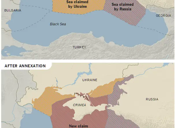
Russia’s New EU Neighbours

Read more: Russia’s New EU Neighbours →
Economic mapsInteractive mapsMapping Health
July 8, 2017 Alex

The Well-Being Map

The Well-Being Map is an online visualization tool that displays measurements of various characteristics for each U.S. county. For characteristics

Read more: The Well-Being Map →
World
July 8, 2017 Alex

The three major Pacific cultural areas

Read more: The three major Pacific cultural areas →
EducationMapping StereotypesSport
July 7, 2017 Alex

Where is [country]?

Where is Iran? Based on a poll carried out by Morning Consult, just 23 percent of voters could correctly identify

Read more: Where is [country]? →
Page 137 of 521« First«...133134135136137138139140141...»Last »

Trending now

  • Soviet detailed map
    Detailed Cold War-era Soviet military map of the San Francisco Bay area (1980)Oct 22, 2017
  • Human races of the 19th century
    How Has Our View of Human Diversity Changed Since the 19th Century?Oct 22, 2017
  • World map of Y-DNA Haplogroups
    World map of Y-DNA HaplogroupsMay 17, 2017

Related Products

  • Push pin maps
  • Globe drinks cabinets
  • Maps of the United States
  • Board games
  • Monopoly
  • Map-based strategy board games
  • History Board Games
  • Coloring Books
  • Handheld GPS
  • GPS Watches
  • GPS Trackers

Vivid Maps Tools

  • Convert Latitude/Longitude
  • Elevation Finder
  • Distance Calculator
  • Kilometers to Miles Distance & Length Converter
  • Weight Converter
  • Volume Converter
  • Daylight Comparison
  • Time Zone Converter
  • Antipodes Map
  • Find cities with a similar climate
  • Find cities with a similar climate (2050)
  • How hot cities could be in 2050
  • The U.S. Population Lines

Stay connected

Get the latest maps, insights and updates delivered to your inbox.

Unsubscribe anytime.

VividMaps

Maps that explain the world.

Beautiful, data-rich maps to help you understand our world — its people, places and connections.

Explore

World map World atlas Map posters Globes

Company

About Privacy Contact

Stay connected

Follow us for the latest maps, insights and updates.

Independent WebsiteVirusScanner trust report for vividmaps.com
© 2026 Vivid Maps. All rights reserved.
A more connected world