Skip to content
VividMaps

  • Atlases
  • Map Posters
  • Scratch Maps
  • Globes
  • Videos
World
July 17, 2017 Alex

Map of the New York City Central Railroad (1918)

“The heart of New York Grand Central Terminal Only Railway Station on the Subway, Elevated and Surface Lines.” Related posts:

Read more: Map of the New York City Central Railroad (1918) →

Ethnic mapsForecasts
July 17, 2017 Alex

White Non-Hispanic population in America (2010 – 2030)

Read more: White Non-Hispanic population in America (2010 – 2030) →
Maps of World Religions
July 17, 2017 Alex

Bible Belts of Europe

Read more: Bible Belts of Europe →
Real estateSize comparison maps
July 17, 2017 Alex

How curved is Europe anyway?

Reddit user: Copse_Of_Trees

Read more: How curved is Europe anyway? →
BuildingMapping StereotypesNatureReal estate
July 16, 2017 Alex

Where the cranes are?

Seattle had more cranes than any other U.S. city as of July, and its lead has only grown over the

Read more: Where the cranes are? →
Cultural cartography
July 16, 2017 Alex

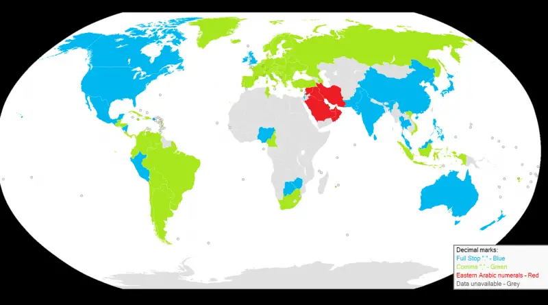
Decimal marks around the world

A decimal separator is a symbol that separates the integer part from the fractional part of a number written in decimal form. Different nations choose different characters for use as a separator. The choice of the symbol also affects the symbol selection for the thousands separator used in digit grouping.

Read more: Decimal marks around the world →
MexicoSlider
July 16, 2017 Alex

Tacography, a map of different tacos from around Mexico (Spanish)

Read more: Tacography, a map of different tacos from around Mexico (Spanish) →
Ethnic mapsSize comparison maps
July 16, 2017 Alex

What thetruesize.com really does

Using thetruesize.com it is apparent that Argentina, compared to Europe, is larger than many had thought. Especially the nothern part

Read more: What thetruesize.com really does →
Economic mapsInteractive mapsInternet
July 16, 2017 Alex

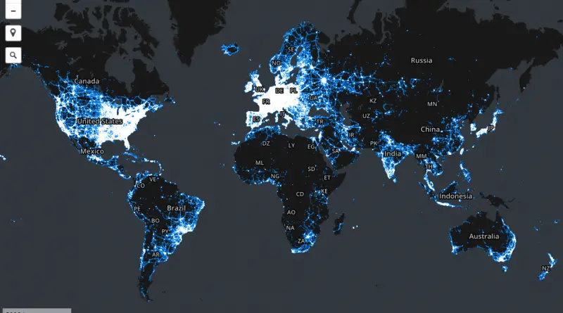
Areas in which our stumbling community has collected data samples

The interactive map below shows general areas for which we have data samples. It does not show the locations of

Read more: Areas in which our stumbling community has collected data samples →
Mapping StereotypesRelief maps
July 16, 2017 Alex

Relief map of the British Isles

Reddit user: AJgloe

Read more: Relief map of the British Isles →
Mapping StereotypesOld maps
July 15, 2017 Alex

Japanese Pictorial World Map, 1932

Japanese pictoral map, showing what were the national stereotypes at the time

Read more: Japanese Pictorial World Map, 1932 →
Historic Italy housing building mapped
Real estate
July 15, 2017 Alex

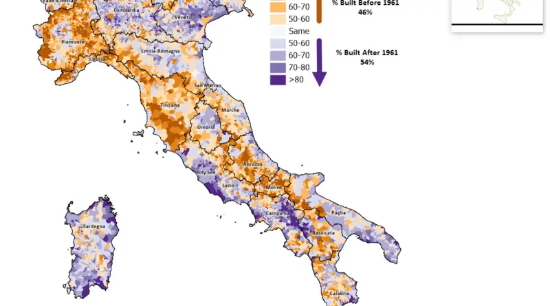
Italy’s Housing Landscape: The Pre- and Post-1961 Building Boom

A striking visualization reveals the patterns of Italy’s residential development, showing which communities preserved their historic buildings and which underwent massive modern expansion after 1961 – a key year that marked the peak of Italy’s economic miracle.

Read more: Italy’s Housing Landscape: The Pre- and Post-1961 Building Boom →
World
July 15, 2017 Alex

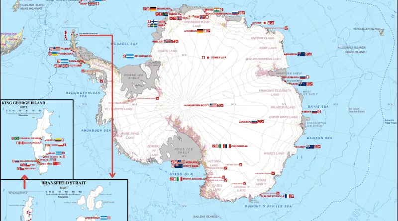
Humans in Antarctica

Credit: Seweryn Szeliga Antarctica has no permanent residents, although it contains research stations and field camps that are staffed seasonally

Read more: Humans in Antarctica →
Page 135 of 521« First«...131132133134135136137138139...»Last »

Trending now

  • Soviet detailed map
    Detailed Cold War-era Soviet military map of the San Francisco Bay area (1980)Oct 22, 2017
  • Human races of the 19th century
    How Has Our View of Human Diversity Changed Since the 19th Century?Oct 22, 2017
  • World map of Y-DNA Haplogroups
    World map of Y-DNA HaplogroupsMay 17, 2017

Related Products

  • Push pin maps
  • Globe drinks cabinets
  • Maps of the United States
  • Board games
  • Monopoly
  • Map-based strategy board games
  • History Board Games
  • Coloring Books
  • Handheld GPS
  • GPS Watches
  • GPS Trackers

Vivid Maps Tools

  • Convert Latitude/Longitude
  • Elevation Finder
  • Distance Calculator
  • Kilometers to Miles Distance & Length Converter
  • Weight Converter
  • Volume Converter
  • Daylight Comparison
  • Time Zone Converter
  • Antipodes Map
  • Find cities with a similar climate
  • Find cities with a similar climate (2050)
  • How hot cities could be in 2050
  • The U.S. Population Lines

Stay connected

Get the latest maps, insights and updates delivered to your inbox.

Unsubscribe anytime.

VividMaps

Maps that explain the world.

Beautiful, data-rich maps to help you understand our world — its people, places and connections.

Explore

World map World atlas Map posters Globes

Company

About Privacy Contact

Stay connected

Follow us for the latest maps, insights and updates.

Independent WebsiteVirusScanner trust report for vividmaps.com
© 2026 Vivid Maps. All rights reserved.
A more connected world