Global Surface Explorer
The European Commission’s Joint Research Centre developed this new water dataset in the framework of the Copernicus Programme. This maps
Read MoreThe European Commission’s Joint Research Centre developed this new water dataset in the framework of the Copernicus Programme. This maps
Read MorePrimary commercial service airports, commonly known as primary airports, are publicly-owned airports that process more than 10,000 passenger boardings per
Read More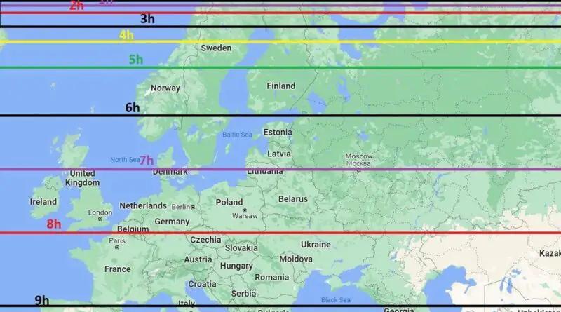
On the winter solstice, which typically falls around December 21st in the Northern Hemisphere, Europeans experience varying durations of daylight depending on their location. The amount of sunlight received during this time of year is influenced by factors such as latitude, proximity to the equator, and geographic features like mountains and bodies of water.
Read MoreHow do big ships navigate the San Francisco Bay? The tracks on this map show telemetry data from 24 hours
Read MoreUnemployed rate, aged 15 years or older. Via ubilabs.net
Read More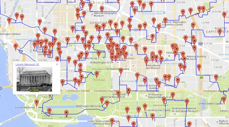
Shortest-possible tour to 50k sites from the National Register of Historic Places. Painting the country with history 217,605-mile walk to
Read More
By Reddit user: crnaruka
Read MoreThat world map on your wall? It’s not telling you the whole truth. Here’s why countries aren’t the size you think they are, and what our world actually looks like.
Read More
The Netherlands means “lower countries” about its low elevation and flat topography, with just approximately 50 percent of its land topping 1 meter (3 feet 3 inches) above sea level and almost 26 percent descending under sea level. The most culmination of the territories below sea level, known as polders, is land reclamation in the 14th century.
Read More