Skip to content
Vivid Maps Logo

  • Atlases
  • Map Posters
  • Scratch Maps
  • Globes
  • Videos
Mapping Stereotypes
December 12, 2016 Alex

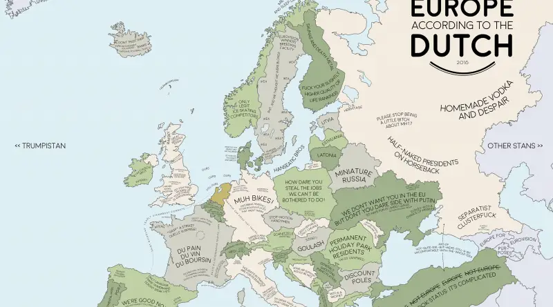
Europe according to the Dutch

The Dutch pioneered capitalism and influenced how the world thinks about free markets. But their view of Europe comes from more than economics. Distance feels different in a small country. Directness is normal. Everyone bikes everywhere. These stereotype maps capture how Dutch cultural traits shape perceptions of neighboring countries.

Read More
Interactive mapsReal estate
December 11, 2016 Alex

Building Age New York City

While New York City is known for its progressiveness and modernity, it is also a city of famous history and culture. When Manhattan was still New Amsterdam and its immigrant roots were starting, the concrete jungle that we know nowadays was a farmyard. The maps below shows the exact age of almost every building in Manhattan from 1719 to 2019, in one map.

Read More
ForecastsGPSSpaceVivid maps
December 11, 2016 Alex

Global Navigation Satellite Systems availability

The maximum possible number of navigation satellites (GPS + GLONASS) which can be “seen” from every point on Earth on

Read More
FoodHeat mapsInteractive maps
December 11, 2016 Alex

~50,000 odd pub locations in Great Britain

Walking distance to the nearest pub

Read More
BusinessEconomic mapsRelief maps
December 11, 2016 Alex

How much you need to earn to be in the top 1% of every U.S. state?

  For the Unites States overall, the income threshold required to be in the 1% of earners is $389,436. Via

Read More
GoogleScienceSlider
December 11, 2016 Alex

Cost obsessions Australian map

Cost obsessions in Australia using Google autocomplete.  Via dannybishopcreative.wordpress.com

Read More
Slider
December 11, 2016 Alex

Population distribution (and roads) of Greenland

With about 56,000 inhabitants, Kalaallit Nunaat (Greenland) can be considered a micronation on a mega island. More than simply a

Read More
Second most spoken language in Canada 2025 mapped
Languages
December 11, 2016 Alex

Canada’s 2nd Most Spoken Language: 1925 vs 2025

Ukrainian and German used to be Canada’s other languages, the ones you’d hear on prairie homesteads and in mining towns. Now it’s Punjabi, Tagalog, Mandarin. These two maps show what happened when Canada changed its immigration rules in 1967.

Read More
Historical MapsHumanity
December 11, 2016 Alex

Human population through time

– Modern humans evolved in Africa about 200,000 years ago. – About 100,000 years ago, we began migrating across the

Read More
HumorInteractive mapsOld maps
December 10, 2016 Alex

Bird’s eye view map of part of the Korean Peninsula

by Hatsusaburo Yoshida (1884-1955)

Read More
Page 264 of 679« First«...102030...262263264265266...270280290...»Last »

Trending now

  • Mapped: Countries in which an official language is primarily written in a script developed within their modern-day borders
    Where Did Your Alphabet Really Come From?
  • Historical Maps of the United States and North America

Related Products

Push pin maps · Globe drinks cabinets · Maps of the United States · Board games · Monopoly · Map-based strategy board games · History Board Games · Coloring Books · Handheld GPS · GPS Watches · GPS Trackers

Vivid Maps Tools

· Convert Latitude/Longitude
· Elevation Finder
· Distance Calculator
· Kilometers to Miles Converter
· Kilograms to Pounds Converter
· Liters to Gallons Converter
· Temperature Converter
· Antipodes Map
· Find cities with a similar climate
· Find cities with a similar climate (2050)
· How hot cities could be in 2050
· The U.S. Population Lines

About
Privacy Policy

Copyright © 2026 Vivid Maps. All rights reserved.