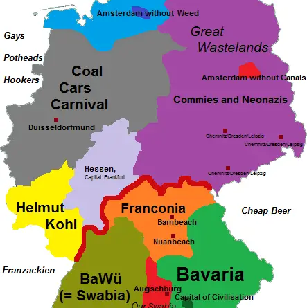
Skip to content
Vivid Maps Logo

  • Atlases
  • Map Posters
  • Scratch Maps
  • Globes
  • Videos
World map: All Ice on Earth Melted
Climate ChangeEnvironment mapsNewsVivid maps

When All the Ice Melts — and When the Oceans Disappear

September 9, 2025 Alex
Global Coffee Arabica Cultivation Mapped
AgricultureNewsVivid maps

From Highland Peaks to Lowland Valleys: Mapping the World’s Coffee and Tea Territories

August 19, 2025 Alex
Mapped Wheat Maize and Rice production
AgricultureNewsVivid maps

Wheat, Maize, and Rice: Mapping the Crops That Feed the World

August 15, 2025 Alex
World map: All Ice on Earth Melted
Climate ChangeEnvironment mapsNewsVivid maps

When All the Ice Melts — and When the Oceans Disappear

September 9, 2025 Alex
Mapped: Where the folk belief of the "Evil Eye" is common
Cultural cartography

Why So Many Cultures Still Fear the “Evil Eye”

August 25, 2025 Alex
Global Coffee Arabica Cultivation Mapped
AgricultureNewsVivid maps

From Highland Peaks to Lowland Valleys: Mapping the World’s Coffee and Tea Territories

August 19, 2025 Alex
Mapped Wheat Maize and Rice production
AgricultureNewsVivid maps

Wheat, Maize, and Rice: Mapping the Crops That Feed the World

August 15, 2025 Alex
Transport
November 26, 2016 Alex

Public transportation map of Tokyo

The public transportation network in Greater Tokyo includes rail and highway networks, airports, buses, walking, and bicycling. The transportation network makes the sprawling city easily accessible and provides the Japanese to commute to Tokyo from other prefectures.

Read More
InternetWorld
November 26, 2016 Alex

Geography of unsecured Wi-Fi Access points

Read More
GoogleInternetMapping StereotypesPopulation
November 26, 2016 Alex

“What to see in…” autocompleted by Google for each country on this map

Read More
Mapping Stereotypes
November 26, 2016 Alex

Toponymic Fantasy Map of Texas

Read More
Animated mapsMetro mapsPolitical maps
November 26, 2016 Alex

Change in margin between 2004 & 2016 elections

Related posts: – The power of small U.S. states – 3D map of county-level election results – Geographically approximate, population-normalized

Read More
Languages
November 26, 2016 Alex

States and Union Territories of India by the Most Commonly Spoken First Language

Read More
Languages
November 25, 2016 Alex

Percentage of pupils in general upper secondary education learning French

16.4 percent of Europeans are learning French.

Read More
Historical MapsMapping StereotypesVideo
November 25, 2016 Alex

European History (1150 – 1700): Every year

European History (1150 – 1453) European History (1453 – 1700)

Read More
CarsInteractive maps
November 25, 2016 Alex

Car accidents in Birmingham

This visualization is showing 28519 car accidents that happened in the city of Birmingham during last years. This data are

Read More
Political maps
November 24, 2016 Alex

The power of small U.S. states

Related posts: – 3D map of county-level election results – Geographically approximate, population-normalized 2016 voting results using congressional districts –

Read More
Page 266 of 674« First«...102030...264265266267268...280290300...»Last »

Trending now

  • The Price of Sex around the World Mapped
  • Map the most common birth months
    The Most Common Birth Months Worldwide, Mapped

Related Products

Push pin maps · Globe drinks cabinets · Maps of the United States · Board games · Monopoly · Map-based strategy board games · History Board Games · Coloring Books · Handheld GPS · GPS Watches · GPS Trackers

Vivid Maps Tools

· Convert Latitude/Longitude
· Elevation Finder
· Distance Calculator
· Kilometers to Miles Converter
· Kilograms to Pounds Converter
· Liters to Gallons Converter
· Temperature Converter
· Find cities with a similar climate
· Find cities with a similar climate (2050)
· How hot cities could be in 2050
· The U.S. Population Lines

About
Privacy Policy

Copyright © 2025 Vivid Maps. All rights reserved.