Skip to content
VividMaps

  • Atlases
  • Map Posters
  • Scratch Maps
  • Globes
  • Videos
EducationLanguagesMapping StereotypesSliderWorld
March 21, 2016 Alex

The most attractive accents in the British Isles

YouGov asked British adults to say whether they think each of the 12 main accents of the British Isles are

Read more: The most attractive accents in the British Isles →

Historical MapsOld maps
March 21, 2016 Alex

The World according to Eratosthenes (BC 220)

Eratosthenes is the ancient Greek geographer and mathematician associated with eventing the first system of Longitude and Latitude. He was also the first know scientist to determine the circumference of our planet. It is a facsimile of the world map (around 220 BC) that Eratosthenes created based on his estimations.

Read more: The World according to Eratosthenes (BC 220) →
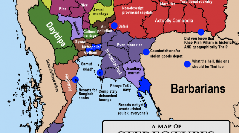
Stereotypes of thailand mapped
Mapping Stereotypes
March 21, 2016 Alex

Stereotype maps of Thailand

Thailand is a nation in Southeast Asia, covering 513,120 sq km (198,120 sq mi), with a population of over 67

Read more: Stereotype maps of Thailand →
Environment maps
March 21, 2016 Alex

Light pollution in Europe

Europe is one of the most light-polluted continents on Earth. Sixty percent of Europeans live in regions where the night sky is so bright that the Milky Way is lastingly invisible. Ninety-nine percent of Europeans live in areas that are influenced by light pollution to any measurable extent.

Read more: Light pollution in Europe →
Animated mapsClimate Change
March 20, 2016 Alex

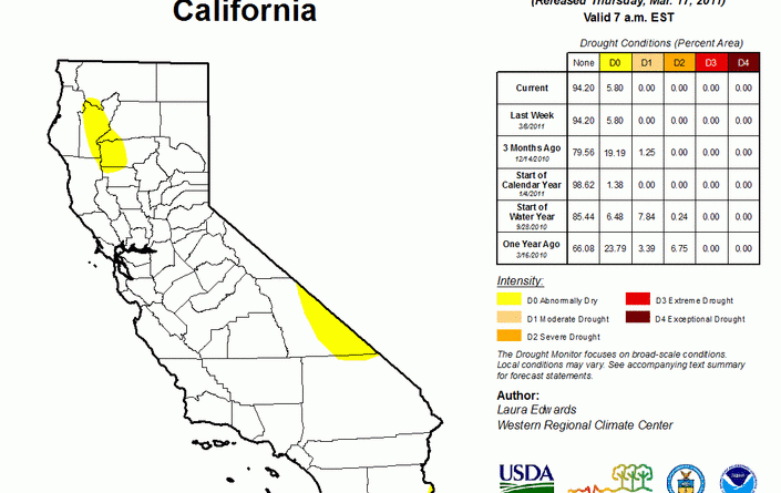
California drought map (2011 – 2016)

Read more: California drought map (2011 – 2016) →
Historical MapsInteractive mapsWars
March 20, 2016 Alex

How the Allies bombed Hitler and Nazis into submission

The animation was created by the Imperial War Museum to mark the re-opening of the American Air Museum. It shows

Read more: How the Allies bombed Hitler and Nazis into submission →
Entertainment
March 20, 2016 Alex

Eurovision winners

Map showing each country’s number of Eurovision wins up to and including 2015. Number of Eurovision 2nd places of countries,

Read more: Eurovision winners →
LanguagesSlider
March 20, 2016 Alex

Main plural endings of nouns in Norwegian dialects

Read more: Main plural endings of nouns in Norwegian dialects →
Terrorism
March 19, 2016 Alex

Islamic State territorial gains and losses (2015)

Read more: Islamic State territorial gains and losses (2015) →
CitiesClimate ChangeMapping Stereotypes
March 19, 2016 Alex

Winter temperatures compared to the 1981 – 2010 average

Winter temperatures (December 2015-February 2016) compared to the 1981-2010 average. It was the contiguous U.S.’ warmest winter on record.

Read more: Winter temperatures compared to the 1981 – 2010 average →
BusinessCitiesMapping StereotypesTechnology
March 19, 2016 Alex

3D print your city

3D print your favorite map tile. Enter your coordinates to generate an OBJ file that you can send to a

Read more: 3D print your city →
Wars
March 19, 2016 Alex

Mapping Russian Airstrikes in Syria

Russian airstrikes were concentrated in areas held by rebels (yellow) who are not affiliated with the Islamic State (red) and

Read more: Mapping Russian Airstrikes in Syria →
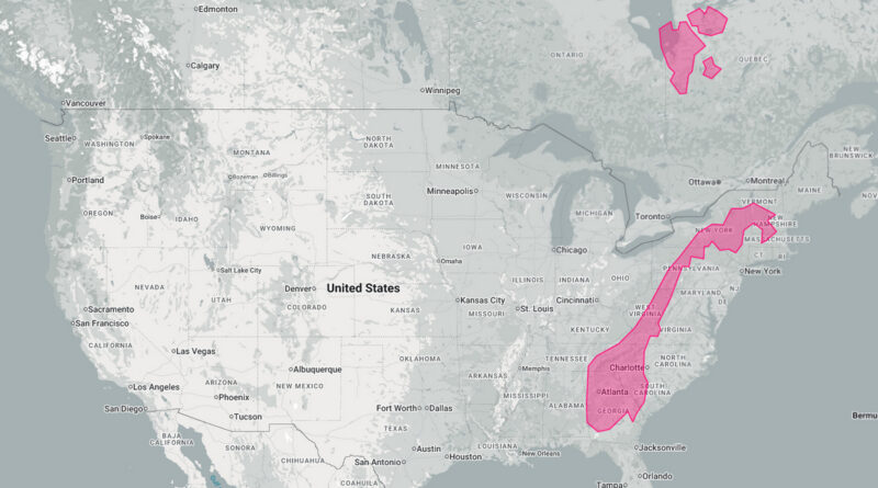
Mapped: How long is Norway? (Norway vs United States)
Size comparison maps
March 19, 2016 Alex

How long is Norway?

Norway may look slim on the globe, but it stretches 1,750 km north to south-long enough to cover Ireland to North Africa, or Vermont to Georgia.

Read more: How long is Norway? →
Page 323 of 521« First«...319320321322323324325326327...»Last »

Trending now

  • Soviet detailed map
    Detailed Cold War-era Soviet military map of the San Francisco Bay area (1980)Oct 22, 2017
  • World map of Y-DNA Haplogroups
    World map of Y-DNA HaplogroupsMay 17, 2017
  • Maps of differences between East and West Germany
    Germany is still divided by east and westSep 11, 2020

Related Products

  • Push pin maps
  • Globe drinks cabinets
  • Maps of the United States
  • Board games
  • Monopoly
  • Map-based strategy board games
  • History Board Games
  • Coloring Books
  • Handheld GPS
  • GPS Watches
  • GPS Trackers

Vivid Maps Tools

  • Convert Latitude/Longitude
  • Elevation Finder
  • Distance Calculator
  • Kilometers to Miles Distance & Length Converter
  • Weight Converter
  • Volume Converter
  • Daylight Comparison
  • Time Zone Converter
  • Antipodes Map
  • Find cities with a similar climate
  • Find cities with a similar climate (2050)
  • How hot cities could be in 2050
  • The U.S. Population Lines

Stay connected

Get the latest maps, insights and updates delivered to your inbox.

Unsubscribe anytime.

VividMaps

Maps that explain the world.

Beautiful, data-rich maps to help you understand our world — its people, places and connections.

Explore

World map World atlas Map posters Globes

Company

About Privacy Contact

Stay connected

Follow us for the latest maps, insights and updates.

Independent WebsiteVirusScanner trust report for vividmaps.com
© 2026 Vivid Maps. All rights reserved.
A more connected world