Skip to content
VividMaps

  • Atlases
  • Map Posters
  • Scratch Maps
  • Globes
  • Videos
Subway map of human body
Humanity
August 26, 2019 Alex

Subway Map of Human Anatomy

The structure of our body is very complex, and it is challenging for someone without a medical background to understand how the various systems of the human body function, even if you have an atlas of anatomy handy. What if we tried to create an even easier-to-understand visualization of the human body?

Read more: Subway Map of Human Anatomy →
Hispanic in the U.S.
Ethnic maps
August 24, 2019 Alex

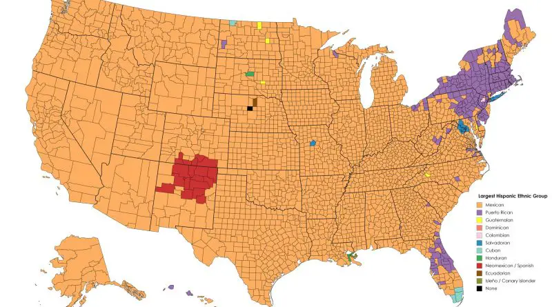
Map of the largest Hispanic ethnic group in each U.S. county

Among the 65 million Hispanics in the U.S. 2/3 has of Mexican origin. Puerto Ricans, the nation’s second-largest Hispanic origin group.

Read more: Map of the largest Hispanic ethnic group in each U.S. county →
Economic maps
August 19, 2019 Alex

The most socially mobile countries visualized

17 of the top 20 most socially mobile countries will be in Europe. Still, the Nordic countries lead the ranks due to their high-quality educational systems, strong social safety nets, inclusive institutions, and good job opportunities. Denmark holds the crown for the most socially mobile nation globally, with a Social Mobile Index score of 85.2.

Read more: The most socially mobile countries visualized →
Economic maps
August 19, 2019 Alex

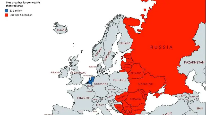
Comparison of the Wealth

National net wealth is the total amount of the value of a nation’s assets minus its debts. It refers to the total value of net wealth owned by the residents of a nation.

Read more: Comparison of the Wealth →
Historical Maps
August 18, 2019 Alex

The Ephemeral States of the Napoleonic Period

With a laurel crown upon his head and the Grande Armee at his command, Napoleon Bonaparte, Emperor of the French, led his sovereign proto-nation down a path diverging from the Republican principles it fought so long to uphold, espousing devotion to the spirit of the revolution under autocratic rule – his rule.

Read more: The Ephemeral States of the Napoleonic Period →
Old maps
August 15, 2019 Alex

The kiss of the oceans (1915)

Panama Canal was opened on August 15, 1914. France began work on the canal in 1881 but stopped due to a high worker mortality rate. The U.S. took over the project in 1904.

Read more: The kiss of the oceans (1915) →
Most popular social network
Internet
August 9, 2019 Alex

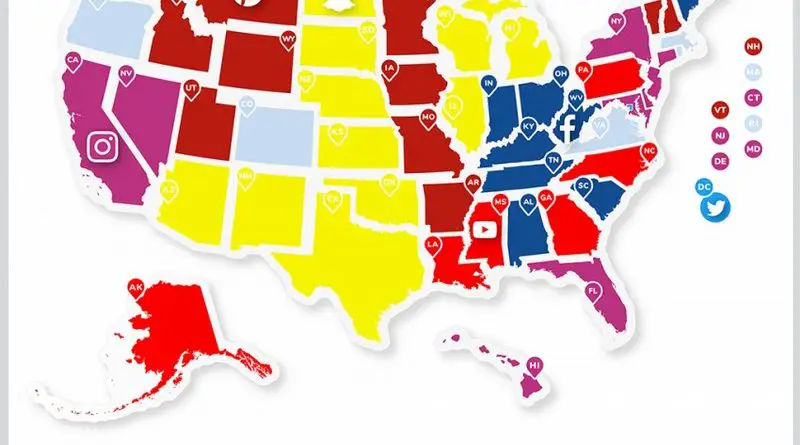
Most Popular Social App by U.S. State

Social networks are internet social media sites to stay connected with family, friends, colleagues, or clients. Facebook remains the largest and most popular social network worldwide, with almost 3 billion users using the platform monthly.

Read more: Most Popular Social App by U.S. State →
Insufficient sleep
Mapping Health
August 3, 2019 Alex

Insufficient sleep in every US county

Sleep insufficiency is the condition of insufficient duration or quality of sleep to sustain proper attention, performance, and health. It’s estimated that sleep insufficiency affects almost 1/3 of American adults.

Read more: Insufficient sleep in every US county →
Environment mapsNewsVivid mapsWorld
July 31, 2019 Alex

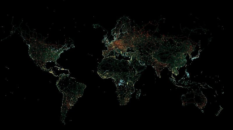
Human-made Infrastructure Mapped

3 percent (4.5 million km2 / 2.8 million mi2) of the Earth’s land cover is occupied by urban areas. However, even non-urban areas contain roads, railroads, and other marks of human presence. Only ten percent of the world is indeed a wilderness.

Read more: Human-made Infrastructure Mapped →
Proportion of people aged 4 and under
DemographyNewsVivid maps
July 23, 2019 Alex

U.S. population aged 0-4 year

Today, the number of children aged 0-4 in the U.S. is 19.7 million. Between 2008 and 2020, the population aged 0-4 years in the United States was declining on average by 0.51 percent every year, although, before that, it rose from 16.6 million persons in 1979 to 21.1 million persons in 2008.

Read more: U.S. population aged 0-4 year →
The safest for travel countries
Travel
July 17, 2019 Alex

The worst and safest countries for travel

The lowest risk has most European nations – Australia, Canada, United States, New Zealand, as are Azerbaijan, Armenia, Georgia, Jordan, Iran, Kuwait, Oman, Qatar, the UAE, and Uzbekistan in the Middle East.

Read more: The worst and safest countries for travel →
US population lines
3D mapsDemographyInteractive mapsNewsVivid maps
July 16, 2019 Alex

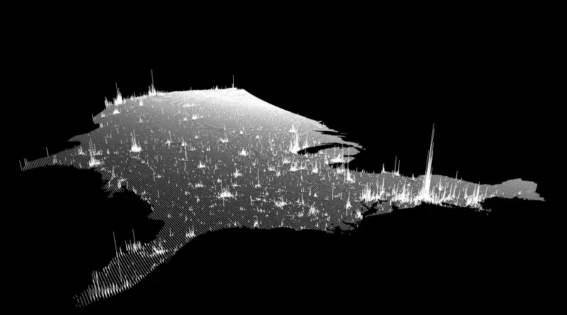
The U.S. Population Lines

The U.S. population is distributed unevenly. The Census evaluates that in the U.S. population living across over 3,000 counties. A mere 140, or 4.5%, of U.S. counties, are home to approximately 50% of those people.

Read more: The U.S. Population Lines →
Proportion of people aged 14 and under mapped
Animated mapsDemographyNewsVivid maps
July 15, 2019 Alex

U.S. population aged 0-14 years

The population of kids aged 14 and under is about 61.4 million in 2020, representing 18.5 percent of the United States population. Population aged 0-14 years of the U.S. fell steadily from 26.9% in 1972 to 18.5% in 2020.

Read more: U.S. population aged 0-14 years →
Page 62 of 521« First«...585960616263646566...»Last »

Trending now

  • Human races of the 19th century
    How Has Our View of Human Diversity Changed Since the 19th Century?Oct 22, 2017
  • Most popular social network
    Most Popular Social App by U.S. StateAug 9, 2019
  • Spread of the industrial revolution in Europe
    Spread of the Industrial RevolutionSep 11, 2021

Related Products

  • Push pin maps
  • Globe drinks cabinets
  • Maps of the United States
  • Board games
  • Monopoly
  • Map-based strategy board games
  • History Board Games
  • Coloring Books
  • Handheld GPS
  • GPS Watches
  • GPS Trackers

Vivid Maps Tools

  • Convert Latitude/Longitude
  • Elevation Finder
  • Distance Calculator
  • Kilometers to Miles Distance & Length Converter
  • Weight Converter
  • Volume Converter
  • Daylight Comparison
  • Time Zone Converter
  • Antipodes Map
  • Find cities with a similar climate
  • Find cities with a similar climate (2050)
  • How hot cities could be in 2050
  • The U.S. Population Lines

Stay connected

Get the latest maps, insights and updates delivered to your inbox.

Unsubscribe anytime.

VividMaps

Maps that explain the world.

Beautiful, data-rich maps to help you understand our world — its people, places and connections.

Explore

World map World atlas Map posters Globes

Company

About Privacy Contact

Stay connected

Follow us for the latest maps, insights and updates.

Independent WebsiteVirusScanner trust report for vividmaps.com
© 2026 Vivid Maps. All rights reserved.
A more connected world