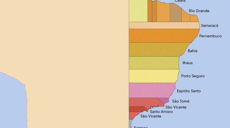
Skip to content
Vivid Maps Logo

  • Atlases
  • Map Posters
  • Scratch Maps
  • Globes
  • Videos
Most popular social network
Internet
August 9, 2019 Alex

Most Popular Social App by U.S. State

Social networks are internet social media sites to stay connected with family, friends, colleagues, or clients. Facebook remains the largest and most popular social network worldwide, with almost 3 billion users using the platform monthly.

Read More
Insufficient sleep
Mapping Health
August 3, 2019 Alex

Insufficient sleep in every US county

Sleep insufficiency is the condition of insufficient duration or quality of sleep to sustain proper attention, performance, and health. It’s estimated that sleep insufficiency affects almost 1/3 of American adults.

Read More
Environment mapsNewsVivid mapsWorld
July 31, 2019 Alex

Human-made Infrastructure Mapped

3 percent (4.5 million km2 / 2.8 million mi2) of the Earth’s land cover is occupied by urban areas. However, even non-urban areas contain roads, railroads, and other marks of human presence. Only ten percent of the world is indeed a wilderness.

Read More
Proportion of people aged 4 and under
DemographyNewsVivid maps
July 23, 2019 Alex

U.S. population aged 0-4 year

Today, the number of children aged 0-4 in the U.S. is 19.7 million. Between 2008 and 2020, the population aged 0-4 years in the United States was declining on average by 0.51 percent every year, although, before that, it rose from 16.6 million persons in 1979 to 21.1 million persons in 2008.

Read More
The safest for travel countries
Travel
July 17, 2019 Alex

The worst and safest countries for travel

The lowest risk has most European nations – Australia, Canada, United States, New Zealand, as are Azerbaijan, Armenia, Georgia, Jordan, Iran, Kuwait, Oman, Qatar, the UAE, and Uzbekistan in the Middle East.

Read More
US population lines
3D mapsDemographyInteractive mapsNewsVivid maps
July 16, 2019 Alex

The U.S. Population Lines

The U.S. population is distributed unevenly. The Census evaluates that in the U.S. population living across over 3,000 counties. A mere 140, or 4.5%, of U.S. counties, are home to approximately 50% of those people.

Read More
Proportion of people aged 14 and under mapped
Animated mapsDemographyNewsVivid maps
July 15, 2019 Alex

U.S. population aged 0-14 years

The population of kids aged 14 and under is about 61.4 million in 2020, representing 18.5 percent of the United States population. Population aged 0-14 years of the U.S. fell steadily from 26.9% in 1972 to 18.5% in 2020.

Read More
30 Most Populous Combined Statistical Areas in the USA
Cities
July 11, 2019 Alex

Most Populous Combined Statistical Areas in the U.S.

Combined Statistical Areas represent multiple metropolitan or micropolitan areas that have an employment interchange of at least 15 percent.

Read More
Portuguese Empire
Historical Maps
July 11, 2019 Alex

Map of all territories of the Portuguese Empire (1419-1999)

The Portuguese Empire was one of the biggest and longest-lived empires in world history; it existed for nearly 6 centuries, from the capture of Ceuta in 1415 to the handover of Portuguese Macau to China in 1999. The Second Portuguese Empire spanned 5.4 million square kilometers or 2.12 million square miles at its peak.

Read More
Education and Unemployment
EducationJob
July 6, 2019 Alex

Education and Unemployment by U.S. Country

Job openings in healthcare, community services, and STEM (science, technology, engineering, and mathematics) will grow the fastest among occupational clusters. American adults hold approximately 16.7 million bachelor’s degrees in science, technology, engineering, and mathematics (75 degrees per 1,000).

Read More
Page 70 of 675« First«...102030...6869707172...8090100...»Last »

Trending now

  • United States Köppen Climate Classification Map
    How America’s Climate Zones Are Shifting
  • Japan and Russia will divide China (propaganda map)
    “Japan and Russia Will Divide China” (1940 Propaganda Map)

Related Products

Push pin maps · Globe drinks cabinets · Maps of the United States · Board games · Monopoly · Map-based strategy board games · History Board Games · Coloring Books · Handheld GPS · GPS Watches · GPS Trackers

Vivid Maps Tools

· Convert Latitude/Longitude
· Elevation Finder
· Distance Calculator
· Kilometers to Miles Converter
· Kilograms to Pounds Converter
· Liters to Gallons Converter
· Temperature Converter
· Find cities with a similar climate
· Find cities with a similar climate (2050)
· How hot cities could be in 2050
· The U.S. Population Lines

About
Privacy Policy

Copyright © 2025 Vivid Maps. All rights reserved.