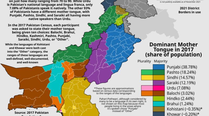
The 27 EU Countries Ranked by Size: From France to Malta
France could fit Malta inside it 1,733 times. This map ranks all EU countries from biggest to smallest with their actual sizes and population densities.
Read MoreFrance could fit Malta inside it 1,733 times. This map ranks all EU countries from biggest to smallest with their actual sizes and population densities.
Read MoreAir conditioning transformed American homes in the 20th century. Here’s how it began, where it’s most common today, and which states hardly use it at all.
Read MoreEurope spent the 1900s breaking countries apart, but some regions never gave up on coming together. From Ireland’s legal reunification pathway to Albania-Kosovo’s passionate public backing, these six unification movements show how popular support and political reality often live in completely different worlds.
Read MoreEver wondered why your morning coffee tastes different from your afternoon tea? The answer lies in altitude, climate, and centuries of agricultural adaptation. Join me on a cartographic journey through the landscapes that bring these beloved beverages to your cup.
Read MoreCountries without coastlines get the short end of the stick. Switzerland figured out how to make it work, but they’re special. Most landlocked nations spend half their time begging neighbors to let goods pass through. Czechoslovakia was fed up with this by the 1970s, leading to one of the most audacious infrastructure dreams of the Cold War era.
Read MoreHeat waves in Europe are no longer rare events. A new map shows how often summer days over 30ºC now occur compared to the early 1980s.
Read MoreWheat, maize, and rice account for most of the world’s cereal production and nearly all daily calories. See where they’re grown around the world, who leads the way in production, and where the three crops overlap.
Read MoreA map of Dominican provinces reveals how religious boundaries established centuries ago still organize communities across Europe, often ignoring today’s political borders.
Read MoreFrom the current 2024–2028 electoral map to a “what-if” version based purely on population, these maps offer a fresh look at how political power is distributed across the United States.
Read MoreSome countries plan for generations, others focus on quick results. Dutch researcher Geert Hofstede mapped these cultural differences in his Long-Term Orientation study. Discover what your country’s approach to planning reveals about its cultural values and decision-making style.
Read More