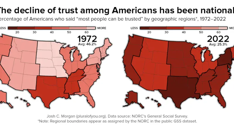
Mapping the Decline of Trust in America
Discover how trust levels across the United States have plummeted from 1972 to 2022, with detailed maps illustrating this concerning trend and exploring the potential causes behind it.
Read MoreMaps of the US
Discover how trust levels across the United States have plummeted from 1972 to 2022, with detailed maps illustrating this concerning trend and exploring the potential causes behind it.
Read More
Uncover the hidden fees for Uber Eats orders across the United States. Our comprehensive analysis and map reveal where users face the highest surcharges, helping you navigate the cost landscape of food delivery services.
Read MoreThe Greater Idaho movement is challenging our perception of state boundaries on the United States map. Several eastern Oregon counties have voted to leave the state and join Idaho, highlighting complex cultural and political divides. This post explores the reasons behind this movement, its potential impact, and what it reveals about America’s diverse geographic landscape.
Read More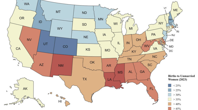
In 2023, 40 % of U.S. births were to unmarried women. This post combines national statistics with state-level breakdowns (including race) and background on teen birth rates and fertility trends.
Read More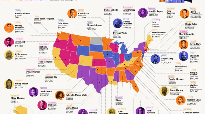
Explore how top American celebrities earn millions from Instagram in every state. From Kevin Hart’s staggering $28 million to Jennifer Lopez’s $9 million, discover the highest-paid stars in sports, acting, and music. Dive into detailed analysis, key findings, and the methodology behind the rankings.
Read More
Outside of major cities, many Americans find life to be more affordable. However, years of high inflation have increased costs for almost everyone. To maintain a comfortable lifestyle, the 50/30/20 budget rule suggests spending about 50% of your income on necessities like food and housing, 30% on wants, and saving or paying off debt with the remaining 20%.
Read More
While you might be aware of the best-paying jobs overall, some roles have much higher salaries in specific regions. Resume.io has examined pay differentials for hundreds of positions across each U.S. state to identify the jobs with the most substantial salary increases from one location to another.
Read More
Time is a fundamental aspect of human existence, and the standardization of time zones has played a crucial role in modern society. In the United States, the evolution of standard time zone boundaries has been a fascinating journey, shaped by historical events, technological advancements, and legislative decisions.
Read More
In the United States, the population of full-time freelancers surged by 91%, while occasional freelancers saw a staggering increase of 132% between 2020 and 2023. Presently, approximately 72.1 million Americans—comprising roughly 45% of the workforce—engage in freelance work either part-time or as their primary occupation, as reported by MBO Partners. Many individuals have reshaped their career trajectories in response to shifting circumstances or expectations brought on by the pandemic, while others have seamlessly integrated into a landscape where freelancing represents a natural evolution.
Read More
While it’s acknowledged that obtaining a college degree can lead to lucrative career opportunities, the question arises: Where in the U.S. do college graduates significantly outearn their non-degree-holding counterparts?
Read More