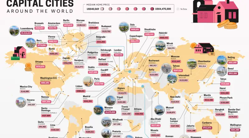
Skip to content
Vivid Maps Logo

Vivid Maps

Maps that explain the World


  • Atlases
  • Map Posters
  • Scratch Maps
  • Globes

World

The largest to smallest landmasses in the world mapped
Physical maps Political maps 

The largest to smallest landmasses in the world mapped

June 18, 2020June 21, 2020 Alex 0 Comments World

One of the most significant disadvantages of the Mercator projection is that it distorts the actual sizes of territories. The atlas below shows the actual size of all countries and dependencies by area.

Read more
Map of happiest and unhappiest countries in the world
Economic maps News Political maps Vivid maps 

The happiest countries in the world (2013 – 2020)

May 7, 2020June 18, 2020 Alex 0 Comments Happiness, World

Happiness connects with many life factors: GDP per capita, social support, healthy life expectancy, freedom to make life choices, generosity, and the absence of corruption. Which country is the happiest?

Read more
Languages 

Language difficulty rankings

November 17, 2017January 11, 2021 Alex 0 Comments Europe, World

The time it takes to learn a language depends on many factors: How close the new language is to your native language or other languages you know; How complex the language is; How many hours each week you devote to learning the language; The language learning resources available to you; Your motivation.

Read more
Human races of the 19th century
Ethnic maps Old maps 

Distribution of Human Races in the 19th Century

October 22, 2017May 28, 2020 Alex 0 Comments Races, World

The idea of race as a rough classification of anatomically modern humans has a problematic history. Before the 19th centuries, the word ‘race’ was used in the sense of “ethnic group” and got its contemporary meaning in the area of anthropology only from the mid-nineteenth century.

Read more
Europe with a 100 meters sea level rise
Climate Change Forecasts 

World with a 100 meters sea level rise

June 13, 2017January 7, 2021 Alex 0 Comments Europe, Global warming, North America, United States, World

The global sea-level rise started around the beginning of the 20th century. From 1900 to 2016, the average sea level on the planet rose by 16–21 centimeters or 6.3–8.3 inches. According to the extreme scenario, an increase in sea level can be presumed as 189 centimeters (6.2 feet) by 2100.

Read more
Map Projections Size comparison maps 

The real size of the world

December 20, 2016November 28, 2020 Alex 0 Comments World

One of the most common maps of the world is in fact, one of the most misleading. The size of

Read more
Map of Spread of humanity
Charts Population 

World population distribution and density by latitude & longitude

September 21, 2016August 17, 2020 Alex 0 Comments World

People are distributed on the planet extremely unevenly. Most of the people on the planet live in subtropical and tropical latitudes. The largest number of people are concentrated in Asia. These maps illustrate the world population by latitude and longitude.

Read more
Internet 

Wikipedia mapped

December 3, 2015January 6, 2021 Alex 0 Comments Wikipedia, World

Wikipedia is a multilingual open online encyclopedia designed and managed by volunteer supervisors. According to Alexa, Wikipedia is one of the most popular internet websites in the world. Wikipedia.org contains almost 60 million pages, which are visited by about 2 billion unique users every month.

Read more
Demography 

The life expectancy of the world population

October 19, 2015November 27, 2020 Alex 0 Comments life expectancy, World

The map below shows countries where the overall average life expectancy is over 80. Nowadays, the average life expectancy at birth in the world is about 71 years.

Read more
Internet 

Global Internet maps

October 11, 2015August 23, 2020 Alex 0 Comments World

In humanity’s history, several technologies have resulted in such broad social and financial changes in a comparatively short period of

Read more
Page 2 of 3«123»

Advertisement

Find Us On Facebook

Vivid Maps

Trending now

  • How Earth Will look With Current International Borders in 250 million years
    Forecasts
  • Map of Africa river basins
    Rivers
  • Sea leverl rise
    Climate Change, News, Oceans
  • Great Lakes
    Lakes
  • Largest Ancestry in the United States
    Ethnic maps

Advertisement


Globe drinks cabinets · Board games · Monopoly · Map-based strategy board games

Vivid Maps Tools

– Find cities with a similar climate
– Find cities with a similar climate (2050)
– How hot cities could be in 2050
– The U.S. Population Lines
– Convert Latitude/Longitude

– About

Copyright © 2021 Vivid Maps. All rights reserved.