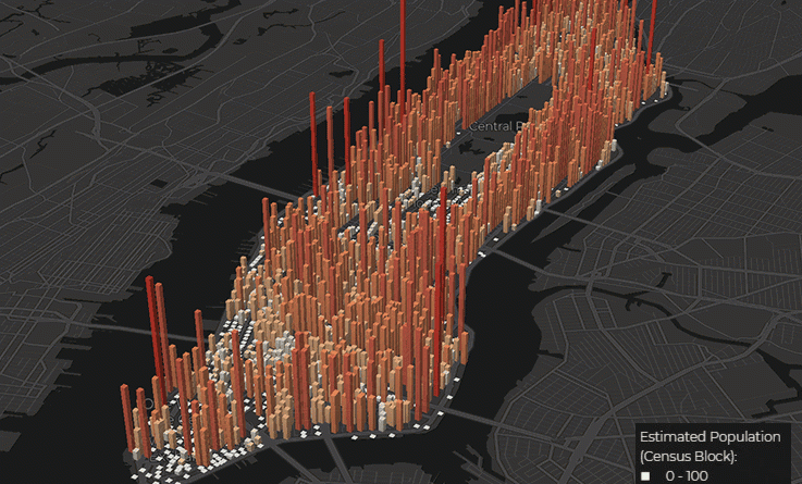
Skip to content
Vivid Maps Logo

  • Atlases
  • Map Posters
  • Scratch Maps
  • Globes
  • Videos
World map of countries based on share of immigrants
DemographyNewsVivid maps

Mapped: Countries With the Lowest Percentage of Immigrants

June 18, 2025 Alex
United States border elevation maped
Environment mapsNewsPolitical mapsVivid maps

United States Border Walls

May 21, 2025 Alex
Cash in the banks by U.S. state mapped
Economic mapsNewsVivid maps

States Where Americans Have the Most Cash in the Bank

May 5, 2025 Alex
Mapped: Which Countries Get the Most Paid Time Off Overall
Economic mapsJob

How Paid Vacation Varies Around the World

August 5, 2025 Alex
Countries wealthier than the global average mapped
Economic maps

Which Countries Are Wealthier Than the Global Average?

July 27, 2025 Alex
Siesta in world countries mapped
Cultural cartography

Siesta Nations: A Map of Midday Rest Traditions Around the World

July 19, 2025 Alex
Difference between male and female BMI by country mapped
Health

Who Has Higher BMI: Men or Women?

June 25, 2025 Alex
Cigarette smoking among adults in the U.S. and Canada
Mapping Health
March 5, 2018 Alex

Smoking Rates in the U.S. and Canada

How do smoking rates in the U.S. and Canada compare? See 2018 data on smoking rates, regional differences, and successful tobacco control measures.

Read More
World countries richer and poorer than Turkey
Economic maps
March 4, 2018 Alex

Is Turkey a Rich or Poor Country? A Look at Global GDP Rankings

Turkey’s GDP (PPP) per capita was $27,630 in 2018. See how Turkey compares to the rest of the world and its neighboring countries in terms of economic strength.

Read More
ORBIS TERRARUM
Old maps
March 3, 2018 Alex

Map of the Ancient Roman World from Their Perspective

Discover how ancient Romans saw the world through maps like Orbis Terrarum and Pomponius Mela’s Orbis Habitabilis. Learn how these maps reflected the Roman Empire’s power and worldview.

Read More
The Great Wall of America
Humor
March 3, 2018 Alex

The Great Wall of America: A Satirical Look at Politics, Guns, and Isolation

Matt Wuerker’s 2018 cartoon “The Great Wall of America” cleverly blends politics, gun culture, and isolationism. Explore the deeper message behind this witty map.

Read More
The World According to Rome
Mapping Stereotypes
March 2, 2018 Alex

The World According to Rome

Step into the mind of Ancient Rome with two humorous maps that show how Romans might have seen the world in 125 AD — from “stinky people” to “crazy religions.”

Read More
Childrens future in Europe
Sociology
March 2, 2018 Alex

Why Are Nordic Countries So Optimistic About Their Children’s Future?

Why are countries like Sweden, Finland, and Denmark so confident about their children’s future? Explore the social policies and factors driving this optimism — and how it’s linked to overall happiness.

Read More
US - Canada border
Size comparison maps
March 2, 2018 Alex

Borders of the United States

The US political borders can be classified into international and internal. An international boundary delineates the space between sovereign nations (Canada-USA-Mexico). Internal boundaries are more bureaucratic and used to break up space into manageable parts of administration.

Read More
Bird Migration
Environment maps
March 1, 2018 Alex

Epic Animal Migrations: How Far Can They Go?

Animals make some of the most incredible journeys on Earth. A falcon flying 10,000 km in 42 days? An Arctic fox walking across sea ice to another continent? Explore these epic migrations through detailed maps and fascinating facts.

Read More
World Map: How Safe Does the World Feel
Crime maps
February 28, 2018 Alex

Who Feels Safe at Night? A Global Look at Safety Perceptions

How safe do people feel walking alone at night? Gallup’s Global Safety Report reveals that global safety perceptions have improved over the past decade — but not everywhere. Find out which countries feel the safest and least safe today.

Read More
The Literal Translation of Country Names
Languages
February 28, 2018 Alex

The Literal Translation of Country Names

Did you know that Canada literally means “The Village” and Ethiopia translates to “Land of Burnt Faces”? Explore these surprising and insightful translations of country names from around the world.

Read More
Page 106 of 673« First«...102030...104105106107108...120130140...»Last »

Trending now

  • Tearing Switzerland apart
  • World map of global precipitation
    The Unequal Distribution of Global Precipitation Mapped

Related Products

Push pin maps · Globe drinks cabinets · Maps of the United States · Board games · Monopoly · Map-based strategy board games · History Board Games · Coloring Books · Handheld GPS · GPS Watches · GPS Trackers

Vivid Maps Tools

· Convert Latitude/Longitude
· Elevation Finder
· Distance Calculator
· Kilometers to Miles Converter
· Kilograms to Pounds Converter
· Liters to Gallons Converter
· Temperature Converter
· Find cities with a similar climate
· Find cities with a similar climate (2050)
· How hot cities could be in 2050
· The U.S. Population Lines

About
Privacy Policy

Copyright © 2025 Vivid Maps. All rights reserved.