5 Maps That Help You Understand Iran
Explore Iran through insightful maps. From its shifting borders and climate to its ethnic, linguistic, and religious diversity
Read more: 5 Maps That Help You Understand Iran

Explore Iran through insightful maps. From its shifting borders and climate to its ethnic, linguistic, and religious diversity
Read more: 5 Maps That Help You Understand Iran
From the Vatican’s 100% immigrant population to countries where foreign-born residents make up less than 0.1% of the total, discover how migration shapes our world through detailed cartographic analysis.
Read more: Mapped: Countries With the Lowest Percentage of Immigrants
Explore a unique missile range map, showing the reach of countries like Iran, Israel, and North Korea. Find out what this map says about global security and missile development today.
Read more: Who Can Reach Whom? A Look at Maximum Missile Ranges Beyond the Big Five
Across Europe, the way windows open varies more than you’d think. This map explores how local climate, customs, and building styles shape a surprising part of everyday life.
Read more: Which Way Do European Windows Open?
From the iconic dollar sign to the modern euro and India’s rupee symbol, currency marks carry history, identity, and more. Explore which countries use them—and why others don’t bother.
Read more: Why Some Countries Have Currency Symbols—And Others Don’t
A 2023 map by cartographer Wanmei Liang highlights the habitats of every elephant species and subspecies in Asia and Africa.
Read more: Elephant Populations Mapped Across Asia and Africa
The seating layout of a parliament might seem like a design detail—but it often reflects deeper political traditions. Here’s what the different setups mean around the world.
Read more: Why Do Parliaments Sit So Differently Around the World?
When Alaska and Hawaii wanted to become states in 1959, not everyone was happy about it. Alaska got 64 yes votes and 20 no votes. Hawaii did better with 76 yes and 15 no. The maps show most of the opposition came from the South.
Read more: How Alaska and Hawaii Became States
A look at how Europe appeared 150 million years ago during the Jurassic—complete with dinosaurs, shallow seas, and scattered islands.
Read more: What Europe Looked Like in the Jurassic Period
Groundwater might be out of sight, but it’s central to everything from farming to clean drinking water. This post dives into where it’s found, how it moves, and why managing it wisely is becoming more urgent in a changing climate.
Read more: Groundwater Resources: Distribution, Recharge Dynamics, and Environmental Challenges
Explore Brazil’s south-up map and discover how changing map orientation can shift your entire view of the world.
Read more: Brazil’s Upside-Down World Map
What if state and county borders weren’t just lines, but barriers shaped by elevation, rainfall, and population? This series of 3D maps that do just that—transforming geographic and demographic data into eye-catching visualizations.
Read more: United States Border Walls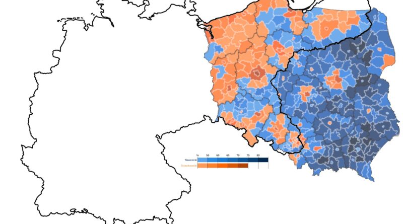
A century after the empires that once ruled Poland vanished, their shadows still linger. This post explores how old imperial borders — now invisible — continue to shape Polish elections.
Read more: Phantom Borders: How Poland’s Past Still Shapes Its Politics