
Skip to content
VividMaps

  • Atlases
  • Map Posters
  • Scratch Maps
  • Globes
  • Videos
EarthquakesInteractive mapsNatural disasters
August 24, 2016 Alex

Interactive Map of the Earthquake in Italy

Via usgs.gov

Read more: Interactive Map of the Earthquake in Italy →
Transport
August 24, 2016 Alex

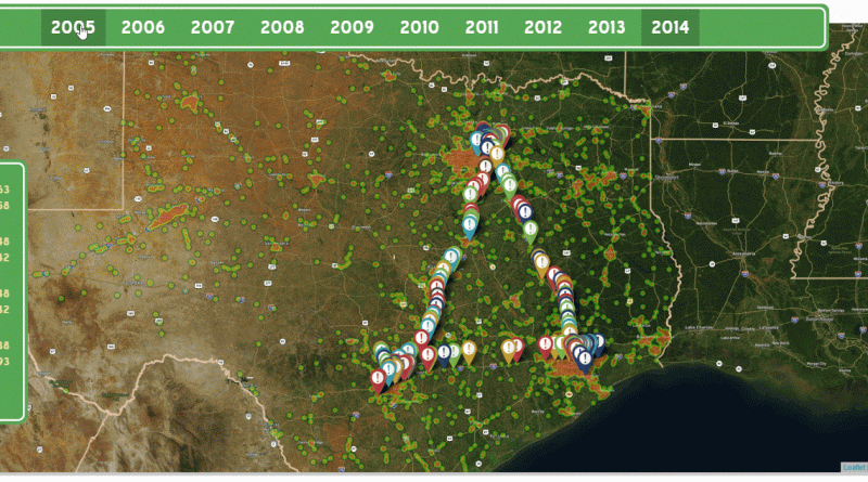
The Texas Triangle

In a densely populated area formed roughly by Dallas, San Antonio, Houston, and Austin lies the Texas Triangle. Outlined by

Read more: The Texas Triangle →
ChartsEmigrationImmigration
August 23, 2016 Alex

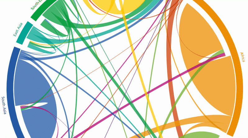
The global flow of people from 1990 to 2010

The circular plot shows the estimates of directional flows between 123 countries that recorded a migration volume (immigration + emigration)

Read more: The global flow of people from 1990 to 2010 →
EntertainmentInteractive maps
August 23, 2016 Alex

Mapping the filming locations

Read more: Mapping the filming locations →
ArtInteractive mapsReal estate
August 23, 2016 Alex

Singapore’s unsold private homes

As Singapore’s property market cools, more private homes are waiting to be snapped up. A total of 31,362 new units

Read more: Singapore’s unsold private homes →
ArtClimate ChangeGlobal Warming
August 22, 2016 Alex

Number of 95°+ days expected in U.S. cities over time

“By the end of the century, the number of 100-degree days will skyrocket, making working or playing outdoors unbearable, and

Read more: Number of 95°+ days expected in U.S. cities over time →
BusinessCartogramsClimate ChangeRivers
August 22, 2016 Alex

International River Basins of Africa

Read more: International River Basins of Africa →
Animated mapsSport
August 22, 2016 Alex

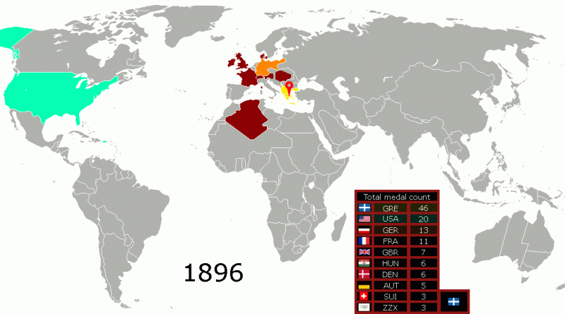
The total Olympic medal count per country (1896 – 2016)

Related posts: – Olympic medal cash reward – The Distribution of Olympic Talent – 2016 Olympics delegation size by nation

Read more: The total Olympic medal count per country (1896 – 2016) →
Economic mapsSliderWorld
August 22, 2016 Alex

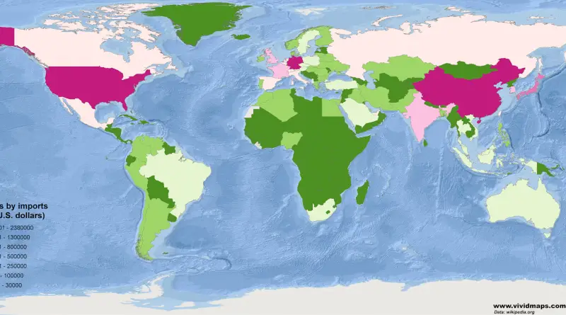
Countries by Imports

An import is a good brought into a jurisdiction, especially across a national border, from an external source. The party

Read more: Countries by Imports →
CartogramsCrime mapsHeat mapsInternetMapping StereotypesWorld
August 21, 2016 Alex

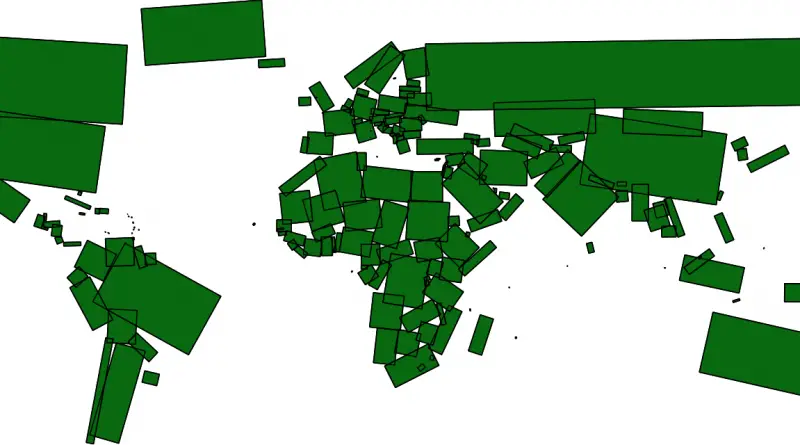
World map by rectangular approximations of country area

Read more: World map by rectangular approximations of country area →
Animated mapsEnvironment mapsIsochrone maps
August 20, 2016 Alex

Species movements due to climate change

“Historically, many species moved great distances as climates changed. However, modern movements will be limited by the patterns of human-dominated

Read more: Species movements due to climate change →
Population
August 20, 2016 Alex

U.S. states with populations comparable to those of UK regions

Read more: U.S. states with populations comparable to those of UK regions →
EducationMapping StereotypesWorld
August 19, 2016 Alex

Most popular books by state (2016)

Books that over-index based off nearly 200 million books bought and sold. Related post: – Most popular books set in each

Read more: Most popular books by state (2016) →
Page 246 of 521« First«...242243244245246247248249250...»Last »

Trending now

  • World Map of the Most Uniquely Popular Word On Every County's Wikipedia Page
    The Most Uniquely Popular Word on Each Country’s Wikipedia Page MappedDec 1, 2022
  • Steel production in 1800 mapped
    220 Years of Steel Production, Mapped From 1800 to 2025Oct 18, 2026
  • Largest Ancestry in the United States
    Largest Ancestry by U.S. CountyMar 23, 2019

Related Products

  • Push pin maps
  • Globe drinks cabinets
  • Maps of the United States
  • Board games
  • Monopoly
  • Map-based strategy board games
  • History Board Games
  • Coloring Books
  • Handheld GPS
  • GPS Watches
  • GPS Trackers

Vivid Maps Tools

  • Convert Latitude/Longitude
  • Elevation Finder
  • Distance Calculator
  • Kilometers to Miles Distance & Length Converter
  • Weight Converter
  • Volume Converter
  • Daylight Comparison
  • Time Zone Converter
  • Antipodes Map
  • Find cities with a similar climate
  • Find cities with a similar climate (2050)
  • How hot cities could be in 2050
  • The U.S. Population Lines

Stay connected

Get the latest maps, insights and updates delivered to your inbox.

Unsubscribe anytime.

VividMaps

Maps that explain the world.

Beautiful, data-rich maps to help you understand our world — its people, places and connections.

Explore

World map World atlas Map posters Globes

Company

About Privacy Contact

Stay connected

Follow us for the latest maps, insights and updates.

Independent WebsiteVirusScanner trust report for vividmaps.com
© 2026 Vivid Maps. All rights reserved.
A more connected world