Skip to content
Vivid Maps Logo

  • Atlases
  • Map Posters
  • Scratch Maps
  • Globes
  • Videos
CitiesInteractive mapsMapping Stereotypes
April 12, 2016 Alex

8 U.S. State populations that fit into the 5 New York boroughs

Related posts: – New York City transit frequency – Yellow Taxi Trips (2015)  – TV Shooting Locations in New York

Read More
CitiesMapping
April 12, 2016 Alex

If downtown Vancouver was a mountain…

This map is not a strict map of Vancouver but a new representation of Vancouver through its building height in

Read More
Largest national identity in the UK local authorities
Ethnic maps
April 12, 2016 Alex

National Identity in the United Kingdom

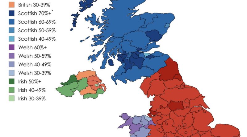
British identity tops 55% in England’s local authorities per 2021 census; Welsh at 55% in Wales, Scottish dominant in Scotland, Northern Ireland divided between Irish and British.

Read More
DemographyEconomic mapsEnvironment mapsMapping StereotypesPollution
April 11, 2016 Alex

Where the poor live longer

– On average, the life expectancy for a poor 40-year-old in Manhattan is 81.8 years. It is one of the

Read More
Environment mapsNature
April 11, 2016 Alex

Noise level from natural sources in the U.S. (excluding humans and human activity)

Read More
ChartsEconomic mapsMapping HealthSize comparison maps
April 11, 2016 Alex

Taxes as % of GDP

Denmark 51% France 45% Norway 39% Germany 36% UK 33% Turkey 29% US 26% Via oecd.org

Read More
Cultural cartography
April 11, 2016 Alex

India explained in 25 maps

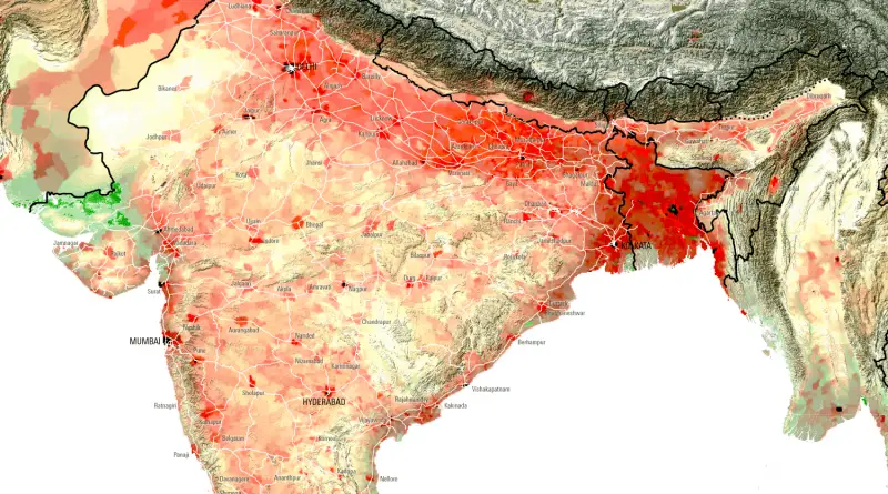
India is a country located in South Asia. It is the 2nd-most populated nation, the 7th-largest country by land area. Settled life appeared on the peninsula in the western boundaries of the Indus river basin 9 thousand years ago, developing slowly into the Indus Valley Civilization of the 3rd millennium BCE.

Read More
CitiesCrime mapsTravel
April 11, 2016 Alex

Crime Rates in Canada: North vs South

Read More
Crime maps
April 11, 2016 Alex

Total number of homicides per police force area

Read More
BusinessMapping StereotypesNature
April 11, 2016 Alex

Fatal Black Bear Attacks in North America

Via www.nationalgeographic.com

Read More
Page 403 of 679« First«...102030...401402403404405...410420430...»Last »

Trending now

  • Decolonisation of Africa mapped
    Atlas of the colonization and decolonization of Africa
  • The largest territorial expanse of the Roman Empire
    The Roman Empire at its Territorial Height

Related Products

Push pin maps · Globe drinks cabinets · Maps of the United States · Board games · Monopoly · Map-based strategy board games · History Board Games · Coloring Books · Handheld GPS · GPS Watches · GPS Trackers

Vivid Maps Tools

· Convert Latitude/Longitude
· Elevation Finder
· Distance Calculator
· Kilometers to Miles Converter
· Kilograms to Pounds Converter
· Liters to Gallons Converter
· Temperature Converter
· Antipodes Map
· Find cities with a similar climate
· Find cities with a similar climate (2050)
· How hot cities could be in 2050
· The U.S. Population Lines

About
Privacy Policy

Copyright © 2026 Vivid Maps. All rights reserved.