Property Prices Index 2016
Property is that which belongs to or with something, whether as an attribute or as a component of said thing.property
Read More
Changing river path seen through satellite images
Sedimentary geologist Zoltan Sylvester downloaded Landsat data using Earth Explorer and strung together images of the Ucayali River (Peru) to
Read MoreA Food and Wine Map of Italy: What Each Region Brings to the Table
From Piedmont’s truffles to Sicily’s bold flavors, each Italian region offers unique dishes and wines. Explore Italy’s diverse culinary landscape through this detailed regional guide.
Read MoreLight pollution in UK
The Dark Sky represented by the darkest shade of blue. Related posts: – Light pollution in Europe: 1992 vs. 2010
Read More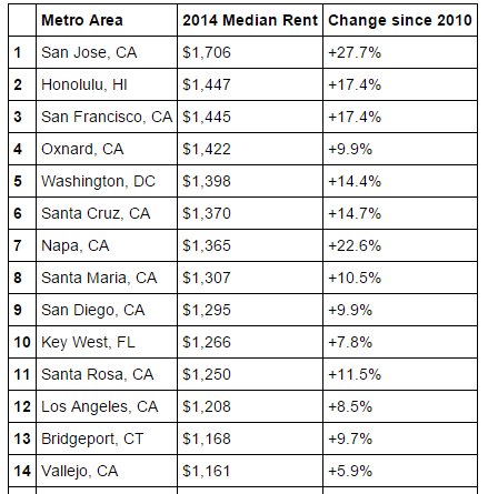
The Landscape of US Rents
U.S. metro areas with the highest median rent U.S. metros with the greatest rent increase U.S. metro areas with the
Read MoreThis map shows which countries are being taken over by robots
Japan was number one with 310,508 operational robots, according to data from 2012. There’s even a hotel staffed almost entirely
Read More