Skip to content
Vivid Maps Logo

  • Atlases
  • Map Posters
  • Scratch Maps
  • Globes
  • Videos
January 29, 2016 Alex

Changes in who controls territories in Syria & Iraq (January 2015 – January 2016)

Read More
AtlasesCultural cartographyLanguagesMaps and AtlasesWorld
January 29, 2016 Alex

The most popular boys names around the World

Read More
Crime mapsInternetMapping HealthSliderWorld
January 29, 2016 Alex

Share of the population suffering from depression

Read More
3D mapsInternetVivid maps
January 29, 2016 Alex

Where are women working in the US?

Read More
AtlasesEnvironment mapsMaps and AtlasesWorld
January 28, 2016 Alex

Ecological footprint: Biocapacity deficit & reserve per country

Read More
AgricultureEnergyInternetSlider
January 28, 2016 Alex

The decarbonization of U.S. electricity

Read More
Environment mapsPollution
January 28, 2016 Alex

NO2 column density change (2005 – 2014)

In urban areas of the United States, levels of NO2 fell, mainly because of environmental regulations that reduced emissions from

Read More
Environment mapsMapping HealthMexicoVivid maps
January 28, 2016 Alex

Where do the oldest Americans live?

Population 85 years and older by county: 2014

Read More
Interactive mapsPolitical mapsWorld
January 28, 2016 Alex

Corruption perceptions Index (2015)

The 2015 Corruption Perceptions Index clearly shows that corruption remains a blight around the world. But 2015 was also a

Read More
Koppen-Geiger climate classification (Hi-res world map)
ClimateNewsVivid maps
January 28, 2016 Alex

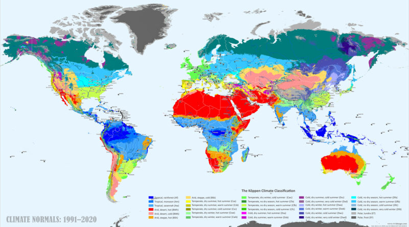
World Map of Köppen-Geiger Climate Classification

High-resolution Köppen-Geiger climate classification maps reveal Earth’s climate zones and how they’re migrating. See current global patterns (1991-2020), compare changes since 1901-1930, and explore projections through 2077-2099 under the ssp2-4.5 scenario.

Read More
Page 451 of 679« First«...102030...449450451452453...460470480...»Last »

Trending now

  • Decolonisation of Africa mapped
    Atlas of the colonization and decolonization of Africa
  • The largest territorial expanse of the Roman Empire
    The Roman Empire at its Territorial Height

Related Products

Push pin maps · Globe drinks cabinets · Maps of the United States · Board games · Monopoly · Map-based strategy board games · History Board Games · Coloring Books · Handheld GPS · GPS Watches · GPS Trackers

Vivid Maps Tools

· Convert Latitude/Longitude
· Elevation Finder
· Distance Calculator
· Kilometers to Miles Converter
· Kilograms to Pounds Converter
· Liters to Gallons Converter
· Temperature Converter
· Antipodes Map
· Find cities with a similar climate
· Find cities with a similar climate (2050)
· How hot cities could be in 2050
· The U.S. Population Lines

About
Privacy Policy

Copyright © 2026 Vivid Maps. All rights reserved.