Percentage of Christians in North America
Religion in North America is dominated by Christianity (77%). Mexico: 87.7% United States: 70.6% Canada: 67.3%
Read more: Percentage of Christians in North America
Religion in North America is dominated by Christianity (77%). Mexico: 87.7% United States: 70.6% Canada: 67.3%
Read more: Percentage of Christians in North AmericaTop 10 countries with highest grow annual GDP (1990 – 2007): 1. Azerbaijan 25% 2. Angola 23.2% 3. Qatar 18%
Read more: Annual GDP growth from 1990 to 2007The average rainfall for the continent is about 670 mm per year but the spatial and temporal distribution is very
Read more: Renewable water resources in AfricaCountries have been divided into ten evenly-sized groups based on their World Givin Index score. The Charities Aid Foundation, and
Read more: World Giving Index 2014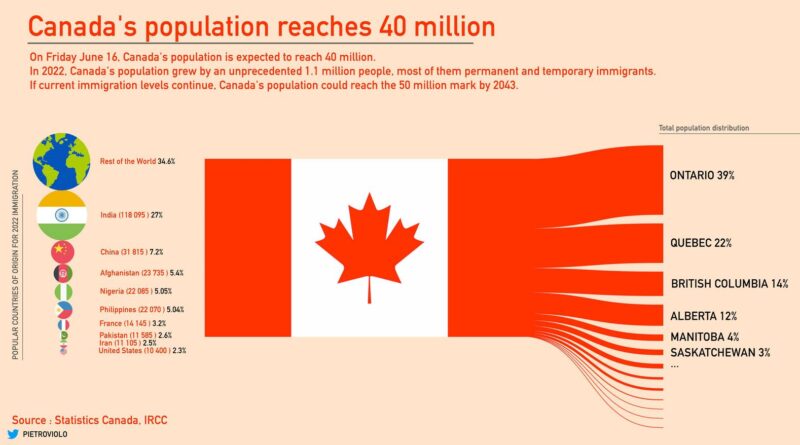
On Friday June 16, 2023, Canada’s population is expected to reach 40 million, making it the 37th most populous country globally. Canada has a low population density due to its vast land area. It averages around 4.2 people per square kilometer, which is one of the lowest population densities in the world.
Read more: Canada’s populationWomen’s Economic Opportunity Index is based on 29 indicators that measure a country’s laws, regulations, practices, customs and attitudes that
Read more: Women`s Economic Opportunity IndexHow Argentinians see Europeans Albania – “Bad” Austria – “Germans” Belgium – “Dumb” Bosnia and Herzegovina – “Muslims” Bulgaria
Read more: How argentinians see europeansWhat is your state the worst at? Alabama: Stroke Alaska: Suicide Arizona: Alcoholism Arkansas: Worst credit score California: Air pollution
Read more: The United States of ShameTallest buildings by state (feet) Alabama – RSA Battle House Tower (745) Alaska – Conoco-Phillips Building (296) Arizona – Chase
Read more: States with buildings taller than their natural highest pointWhat every U.S. State is best at: Alabama – Most concealed carry licenses Alaska – Most pilots per capita Arizona
Read more: What Every U.S. State is Best atThe flag ratios used most commonly are 2:3, used by 89 of 195 sovereign countries, and 1:2, used by 54
Read more: Flag RatiousThe Signature Food Alabama – BBQ Alaska – King Crab Arizona – Mexican Arkansas – Meth cookies California – In-N-Out
Read more: The Signature Food From Every U.S. StateImmigration rate, relative to total population of sending country (rates per thousand) based on 2005 population, U.S. Census.
Read more: Immigration Rate, Relative to Total Population of Sending Country (2006-2010)