
Historical Maps
Historical maps showing territorial changes of countries and historical events of the past.
Nicknames of the States (1884)
H.W. Hill & Co. Decatur Illinois sole manufacturer of Hill’s hog ringers (1884)
Read more: Nicknames of the States (1884)Romani victims of the Holocaust as a percentage of the pre-war population
The Romani victims of the Holocaust, also known as the Porajmos, were a tragically significant group that endured immense suffering during World War II. The Romani people, a diverse and historically marginalized ethnic minority, faced persecution under the Nazi regime’s racist ideology.
Read more: Romani victims of the Holocaust as a percentage of the pre-war population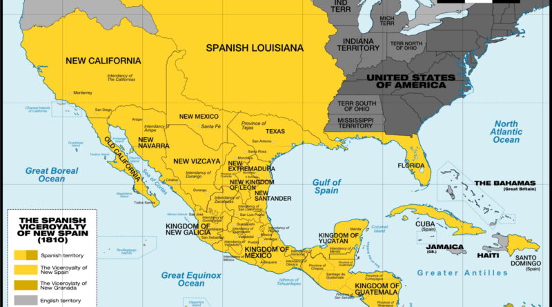
New Spain at Its Height in 1810
Hard to picture, but in 1810 New Spain connected places like California, Cuba, and the Philippines under Mexico City’s control. The map here shows that giant layout across continents, just before a priest sparked revolts that led to all the countries we have today.
Read more: New Spain at Its Height in 1810Partition of Germany
The situation in Germany after the Second World War was disastrous. Millions of Germans were homeless from Allied bombing operations that demolished entire cities. And millions more Germans living in Poland and East Prussia became exiles when the USSR exiled them. With the German economy and governance in shambles, the Allies decided that Germany must be occupied after the war to guarantee a peaceful transformation to a post-Nazi state.
Read more: Partition of GermanyWhat Happened to the Greeks of Asia Minor? A Historical Map, a Population Exchange, and a Lost World
A rare 1918 ethnic map of Greece, Bulgaria, and western Turkey reveals a once-diverse region transformed by conflict and the 1923 population exchange.
Read more: What Happened to the Greeks of Asia Minor? A Historical Map, a Population Exchange, and a Lost World50 Centuries in 10 Minutes
A geopolitical history of all empires, nations, kingdoms, armies and republics. More than 500 world maps spanning all historical events
Read more: 50 Centuries in 10 Minutes