Skip to content
Vivid Maps Logo

  • Atlases
  • Map Posters
  • Scratch Maps
  • Globes
  • Videos
Historical MapsLanguages
October 11, 2017 Alex

Languages of the Byzantine Empire (580 AD)

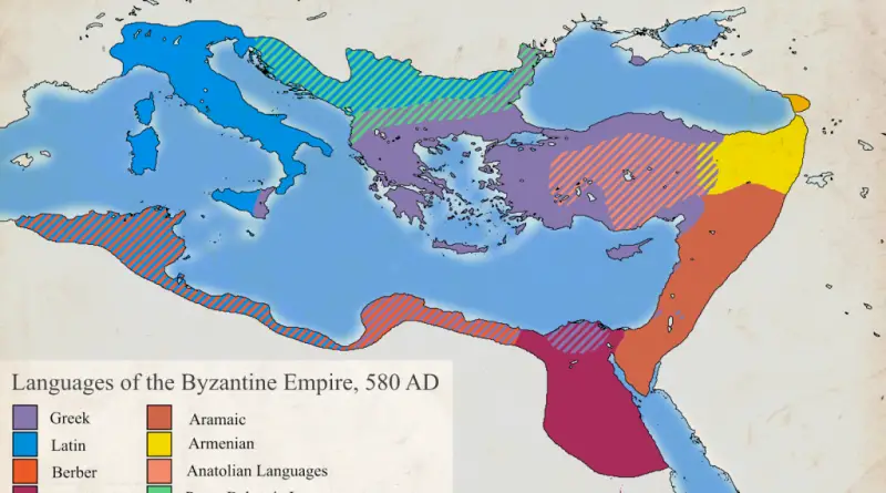
Reddit user: FrankCesco Greek and Latin were the official languages in the Byzantine Empire. Although Latin was the official language

Read More
Interactive mapsMapping StereotypesMaps of World ReligionsSliderVivid maps
October 10, 2017 Alex

Population penetration, Hindu groups in the United States

Most Hindu counties in America: 1. Rabun County, Georgia – 8.9% 2. Juniata County, Pennsylvania – 6.3% 3. Saguache County,

Read More
MarsSpace
October 10, 2017 Alex

Ancient Mars

The map below shows the planet Mars during the late Noachian Period, around 3.8 billion years ago, labeled with modern

Read More
FoodInteractive mapsMapping Stereotypes
October 10, 2017 Alex

The food capitals of Instagram

Locations of photos with food hashtags were obtained from Instagram API. The dataset includes locations of over 100,000 photos posted

Read More
The Number of skyscrapers by State
BuildingInternetLanguages
October 10, 2017 Alex

The height of the tallest building in every U.S. county

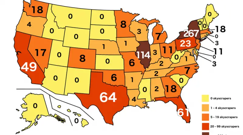
Reddit user: Billtheleaf The tallest buildings in the US cities: New York City: One World Trade Center – 1,792 ft

Read More
DemographyReal estateSlider
October 9, 2017 Alex

Life Expectancy in Europe

Residents of Eastern Europe have the same life expectancy as the inhabitants of some African countries. Reddit user: BuddyWudd Countries

Read More
Climate
October 9, 2017 Alex

Is London Really That Rainy? Comparing the Capital’s Rainfall to the Rest of Europe

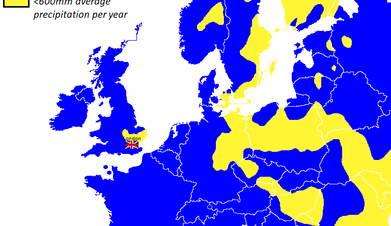
People often think of London as endlessly rainy, but how wet is it really compared to the rest of Europe? The map of Europe created using KNMI data helps clear up the picture.

Read More
Laws
October 8, 2017 Alex

Countries with a ban on corporal punishment of children

In most countries in Europe and South America, corporal punishment of children is prohibited.

Read More
AgricultureMapping StereotypesPopulation
October 7, 2017 Alex

Population density of Europe with U.S. equivalents

A population density of Europe named for similarly dense regions of the United States. Population density of the United States

Read More
BuildingInteractive maps
October 6, 2017 Alex

New York City Construction (1880 – 2017)

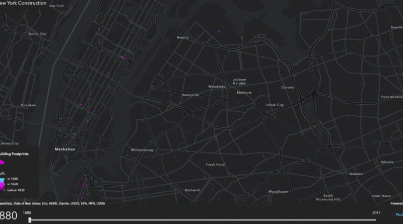
An interactive map showing how houses were built in New York City in the last 50 years.  … NYC maps

Read More
Page 144 of 682« First«...102030...142143144145146...150160170...»Last »

Trending now

  • How El Nino Shifts Rainfall Patterns in Different Part of the World according to WMO
    How El Niño Flips the World’s Rainfall Map
  • Find cities with similar climate

Related Products

Push pin maps · Globe drinks cabinets · Maps of the United States · Board games · Monopoly · Map-based strategy board games · History Board Games · Coloring Books · Handheld GPS · GPS Watches · GPS Trackers

Vivid Maps Tools

· Convert Latitude/Longitude
· Elevation Finder
· Distance Calculator
· Kilometers to Miles Distance & Length Converter
· Weight Converter
· Volume Converter
· Temperature Converter
· Antipodes Map
· Find cities with a similar climate
· Find cities with a similar climate (2050)
· How hot cities could be in 2050
· The U.S. Population Lines

About
Privacy Policy

Copyright © 2026 Vivid Maps. All rights reserved.