Skip to content
VividMaps

  • Atlases
  • Map Posters
  • Scratch Maps
  • Globes
  • Videos
MarsSpace
May 10, 2017 Alex

How the Grand Canyon compares with Mars’ Valles Marineris

Valles Marineris is the most prominent tectonic feature on Mars, consisting of troughs up to 4000 km (2,500 mi) in length, 200 (120 mi) km in width, and 10 km (6.3 mi) in depth. It’s the largest canyons in the solar system.

Read more: How the Grand Canyon compares with Mars’ Valles Marineris →
Political maps
May 10, 2017 Alex

South Korean presidential election results (2017)

Reddit user: mmaronn

Read more: South Korean presidential election results (2017) →
Sociology
May 10, 2017 Alex

Percent of Population 18 and Over That are Veterans

22 million veterans living in the United States. The Department of Veterans Affairs expects the number of living veterans to

Read more: Percent of Population 18 and Over That are Veterans →
Mapping Health
May 10, 2017 Alex

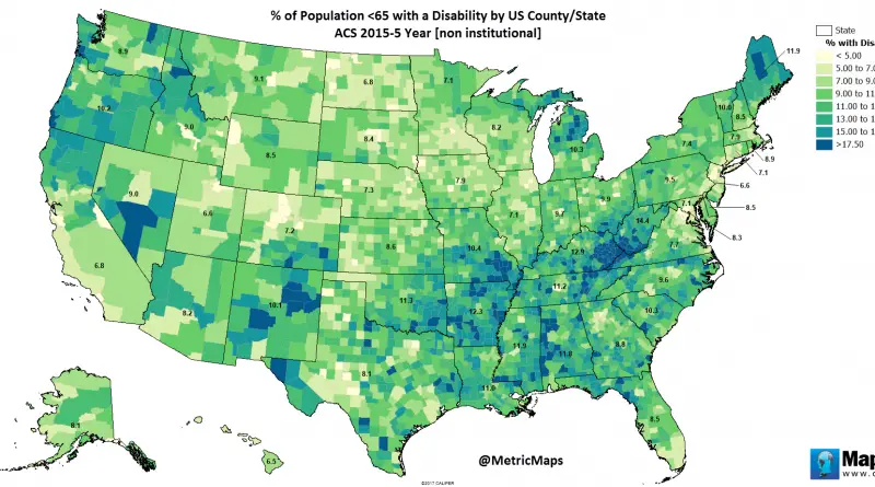
Percent of population with a disability by U.S. county

According to the American Community Survey, an annual survey conducted by the US Census Bureau, the overall percentage of people

Read more: Percent of population with a disability by U.S. county →
EnergyImmigrationVideoWorld
May 10, 2017 Alex

Map of energy consumption by country: 1979-1981 vs 2001-2003

Source: wikipedia.org

Read more: Map of energy consumption by country: 1979-1981 vs 2001-2003 →
Mapping HealthSliderWage
May 10, 2017 Alex

Absolute and relative inequality among U.S. counties in life expectancy & age-specific mortality risks

By 2014, life expectancy in the U.S. had increased for men and women to 79.1 years. But there’s a gap

Read more: Absolute and relative inequality among U.S. counties in life expectancy & age-specific mortality risks →
Old maps
May 10, 2017 Alex

Southwest Asia (1912)

Southwest Asia in the early 20th Century.

Read more: Southwest Asia (1912) →
World
May 9, 2017 Alex

Moxan’s Map with a view of the world as known in 1681

The seven days of creation are illustrated in the panels at the top of the map.

Read more: Moxan’s Map with a view of the world as known in 1681 →
Animated mapsCartogramsMapping HealthTravelVivid mapsWorld
May 9, 2017 Alex

Travel and Tourism % of Total Economy (2017)

Top 10 countries with the largest travel industries (GDP)1. United States ($488 billion)2. China ($224 billion)3. Germany ($130.8 billion)4. Japan

Read more: Travel and Tourism % of Total Economy (2017) →
World
May 9, 2017 Alex

Percent of area covered by water

The U.S. has 264,837 square miles of water, accounting for 7 percent of the total area of the country. Percentage

Read more: Percent of area covered by water →
Ethnic mapsInteractive maps
May 9, 2017 Alex

The Modern Transformation of NYC (2000 – 2015)

The map below between showing the increase in the number of households that earned below $25,000 a year or households

Read more: The Modern Transformation of NYC (2000 – 2015) →
Mapping Health
May 8, 2017 Alex

Change in life expectancy by U.S. county (1980-2014)

Life expectancy for the country as a whole grew by more than 5 years from 1980 to 2014, to an

Read more: Change in life expectancy by U.S. county (1980-2014) →
BusinessEconomic maps
May 8, 2017 Alex

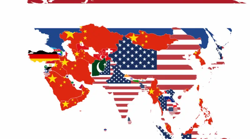
Biggest Export Partners in Asia

Reddit user: sendherhome22 Related post: – What Does Each Asian Country Export the Most to the US?

Read more: Biggest Export Partners in Asia →
Page 156 of 521« First«...152153154155156157158159160...»Last »

Trending now

  • Settlements and native tribes in North America in 1650 Mapped
    The Americas in 1650, Just Before the Dutch and Swedish Colonies EndedOct 22, 2026
  • Map of New Netherland and New Sweden
    The Dutch and Swedish Colonies That Once Held the Mid-Atlantic CoastOct 7, 2023
  • Map of greek colonies
    Ancient Greek Colonies on the Map, From Marseille to CrimeaOct 21, 2026

Related Products

  • Push pin maps
  • Globe drinks cabinets
  • Maps of the United States
  • Board games
  • Monopoly
  • Map-based strategy board games
  • History Board Games
  • Coloring Books
  • Handheld GPS
  • GPS Watches
  • GPS Trackers

Vivid Maps Tools

  • Convert Latitude/Longitude
  • Elevation Finder
  • Distance Calculator
  • Kilometers to Miles Distance & Length Converter
  • Weight Converter
  • Volume Converter
  • Daylight Comparison
  • Time Zone Converter
  • Antipodes Map
  • Find cities with a similar climate
  • Find cities with a similar climate (2050)
  • How hot cities could be in 2050
  • The U.S. Population Lines

Stay connected

Get the latest maps, insights and updates delivered to your inbox.

Unsubscribe anytime.

VividMaps

Maps that explain the world.

Beautiful, data-rich maps to help you understand our world — its people, places and connections.

Explore

World map World atlas Map posters Globes

Company

About Privacy Contact

Stay connected

Follow us for the latest maps, insights and updates.

Independent WebsiteVirusScanner trust report for vividmaps.com
© 2026 Vivid Maps. All rights reserved.
A more connected world