Dominant Ancestry Map of the US and Canada
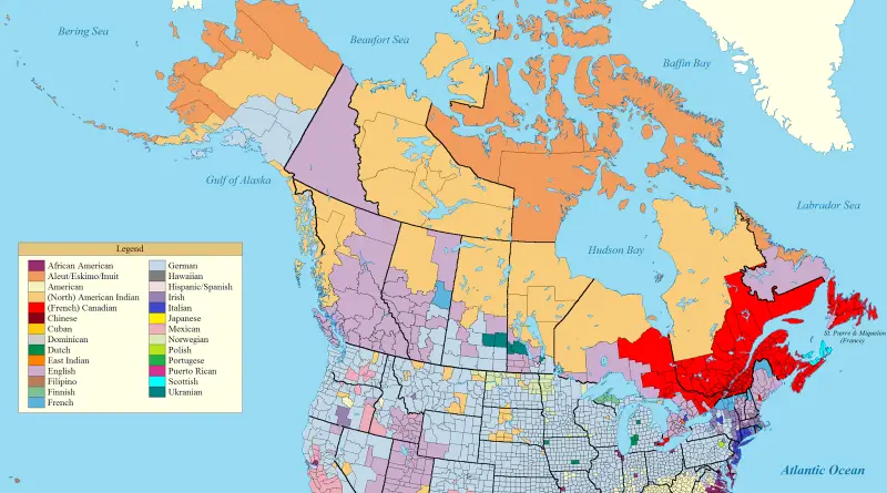
Germans cover the Midwest—41 million Americans. Wisconsin 37% German, North Dakota 36%, some counties hit 64%. Mexicans cluster along the border at 11% of Americans. African Americans dominate where plantations were. English ancestry leads Appalachia and BC. French fills Quebec and northern Maine. Montana is German, southern Saskatchewan is German. But Washington is German and British Columbia is English. Settlement timing and colonial policies created these patterns that persist today.
Read MoreUrban Scratchoff
This site gives you a clever way to explore historical aerial imagery of New York City. You can click and
Read MoreMapping 57,000 Addresses From the Panama Papers
On 9-May-2016, the International Consortium of Investigative Journalists released a database revealing more than 300,000 secret offshore entities, along with
Read MoreWhere the Middle-Class Metros Are Now
The share of adults in the middle-income tier was highest in Wausau, WI (67%) and lowest in Monroe, LA (42%).
Read MoreHow big is Mexico?
Mexico is a nation in the southern part of North America. It is bordered to the north by the U.S., to the southeast by Belize and Guatemala. Mexico is a vast country. It covers almost 2 million square kilometers (~762 thousand sq mi), making it the global’s 13th-biggest nation by area. Moreover, Mexico is a tenth-most-populous nation (about 129 million citizens) and the most populated Spanish-speaking country.
Read MoreLegal systems of the World
The world doesn’t follow one rulebook—there are five major legal systems, each shaped by history, culture, and belief. Discover how countries approach law differently and where these systems are used.
Read More