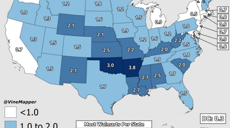
Skip to content
Vivid Maps Logo

  • Atlases
  • Map Posters
  • Scratch Maps
  • Globes
  • Videos
DemographyEthnic mapsPopulationVivid maps
February 11, 2016 Alex

U.S. White Non-Hispanic population, percent increase by county

Related posts: – U.S. population, percent increase by county – U.S. African American population, percent increase by county – U.S.

Read More
Mapping StereotypesPolitical maps
February 11, 2016 Alex

The ‘Archipelago of Disconnection’

For territories coloured orange no individual data exists from the World Bank. Potential reasons are for example: some of these

Read More
ImmigrationInfographicsMapping StereotypesPolitical maps
February 11, 2016 Alex

Results of the 2016 New Hampshire Presidential Primar

Read More
3D mapsAnimated chartsChartsDemographyForecastsImmigrationInternetLawsMapping StereotypesPopulationVivid maps
February 10, 2016 Alex

Population structure of Spain during the 1960-2060 period

Related posts: – Population structure of Turkey during the 1960-2060 period – Population projection (1960 – 2060) – Population structure

Read More
Interactive mapsSatellite images
February 10, 2016 Alex

Megaregions of Ireland

Read More
Global WarmingInfographics
February 10, 2016 Alex

African CO2 emissions

Read More
BusinessMapping StereotypesPopulationSliderVivid maps
February 10, 2016 Alex

U.S. population, percent increase by county

Related posts: – U.S. Population under 5 years of age percent change by county

Read More
ChartsEconomic mapsEnergySliderWorld
February 10, 2016 Alex

Global new investment in renewable power and fuels

Read More
EnergyWorld
February 10, 2016 Alex

Annual sunshine hours map of the World

Read More
Building
February 10, 2016 Alex

Paris Buildings Through Time: A Historical Map Story

A fascinating look at Paris’s architectural timeline through detailed map visualizations, showcasing the city’s growth from ancient times to modern day.

Read More
Page 440 of 675« First«...102030...438439440441442...450460470...»Last »

Trending now

  • The Price of Sex around the World Mapped
  • The most used Emoji in every country
    The Most Used Emoji on Twitter in Every Country Mapped

Related Products

Push pin maps · Globe drinks cabinets · Maps of the United States · Board games · Monopoly · Map-based strategy board games · History Board Games · Coloring Books · Handheld GPS · GPS Watches · GPS Trackers

Vivid Maps Tools

· Convert Latitude/Longitude
· Elevation Finder
· Distance Calculator
· Kilometers to Miles Converter
· Kilograms to Pounds Converter
· Liters to Gallons Converter
· Temperature Converter
· Find cities with a similar climate
· Find cities with a similar climate (2050)
· How hot cities could be in 2050
· The U.S. Population Lines

About
Privacy Policy

Copyright © 2025 Vivid Maps. All rights reserved.