Skip to content
VividMaps

  • Atlases
  • Map Posters
  • Scratch Maps
  • Globes
  • Videos
Economic mapsReal estate
May 4, 2015 Alex

Percentage Of Income Needed For Rent

In only 12 U.S. counties can a full-time worker earning the prevailing federal or state minimum-wage afford a one-bedroom rental

Read more: Percentage Of Income Needed For Rent →

circumcision in the world
Cultural cartographyMaps of World Religions
May 4, 2015 Alex

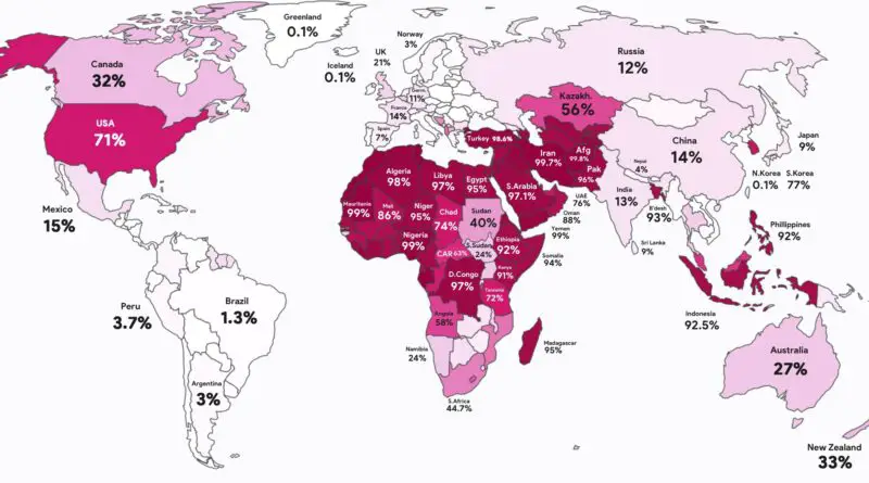
Circumcision Rates by Country, Mapped

Morocco is at 99.9% and Poland at 0.11%. This map showsw here male circumcision is nearly universal, where it is rare, and why the United States stands apart in the West.

Read more: Circumcision Rates by Country, Mapped →
Economic mapsInfographics
May 4, 2015 Alex

Debt to GDP ratio by country

The size of each country corresponds to its Debt to GDP ratio. Countries under 50% are colored green, like Colombia.

Read more: Debt to GDP ratio by country →
Historical MapsMaps of World Religions
May 4, 2015 Alex

How Buddhism Spread Across Asia: Trade, Teaching, and Time

This map tracks the movement of Buddhism from India to Sri Lanka, China, Southeast Asia, and Japan. Along the way, the religion split into different schools and took on new forms.

Read more: How Buddhism Spread Across Asia: Trade, Teaching, and Time →
Economic mapsJob
May 4, 2015 Alex

Countries by Unemployment Rate

Employment rate as a percentage of total population in working age. Top 20 countries with lowest unemployment rate: Cambodia –

Read more: Countries by Unemployment Rate →
Countries by immigrant population
ImmigrationMigration maps
May 3, 2015 Alex

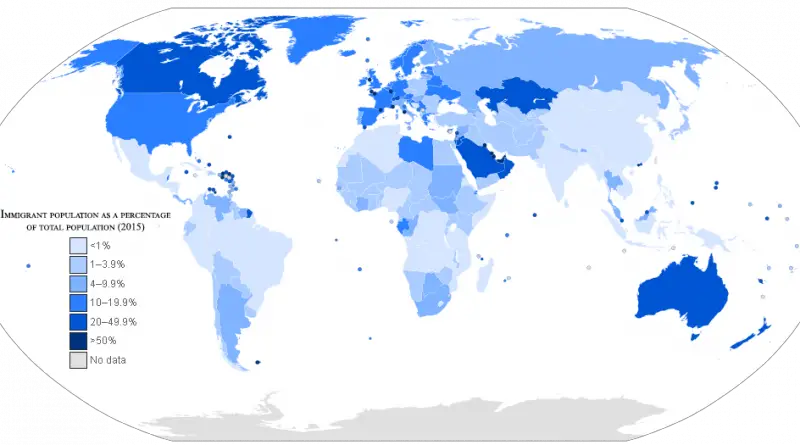
Immigrants Mapped

According to United Nations, The U.S., Germany, and Russia had the most significant number of immigrants of any country, while Tuvalu and Tokelau had the lowest.

Read more: Immigrants Mapped →
Historical MapsOld maps
May 2, 2015 Alex

Europe about 1560

Elizabeth I begins rule; she restores the Protestant Church. The French became the dominant power on the Continent In the

Read more: Europe about 1560 →
Environment mapsWildlife
April 30, 2015 Alex

Global warming could drive 1 in 6 of Earth’s species to extinction

Predicted extinction risks by regions. Predicted extinction risks from climate change differ by region. The highest risks characterized South America,

Read more: Global warming could drive 1 in 6 of Earth’s species to extinction →
Natural disasters
April 30, 2015 Alex

US Drought Map

US drought map focuses on broadscale conditions. Local conditions may vary. In 2015, wildfires burned over 7 mln acres, primarily

Read more: US Drought Map →
Economic mapsReal estate
April 30, 2015 Alex

Rent affordability in the US by county and percentage of gross income

There are more renters now than in the history of the United States. 44,267,432 households with 110,175,847 residents. In total,

Read more: Rent affordability in the US by county and percentage of gross income →
Energy
April 30, 2015 Alex

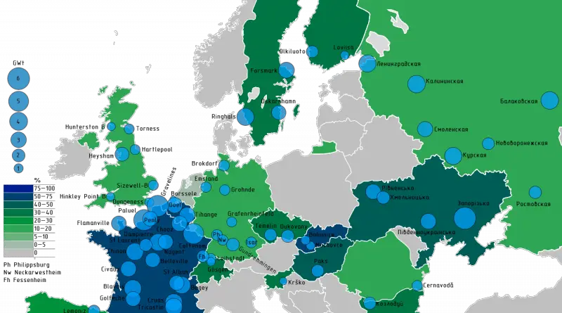
Map of nuclear energy in Europe

17 European countries have nuclear reactors. The countries with reactors are Belarus, Belgium, Bulgaria, Czech Republic, Finland, France, Germany, Hungary,

Read more: Map of nuclear energy in Europe →
Internet
April 29, 2015 Alex

The most popular word used in online dating profiles in each U.S. state

The most popular word used in online dating profiles: hunting, farm and oil.

Read more: The most popular word used in online dating profiles in each U.S. state →
Economic mapsInfographicsResources
April 29, 2015 Alex

World Comparison of Petrol Prices

Norway has the highest fuel cost, Venezuela – the lowest. Top 10 most expensive countries Norway Hong Kong Netherlands Italy

Read more: World Comparison of Petrol Prices →
Page 506 of 521« First«...502503504505506507508509510...»Last »

Trending now

  • Human races of the 19th century
    How Has Our View of Human Diversity Changed Since the 19th Century?Oct 22, 2017
  • Spread of the industrial revolution in Europe
    Spread of the Industrial RevolutionSep 11, 2021
  • The “How do I…” question each U.S. state googles more than any other stateJan 28, 2017

Related Products

  • Push pin maps
  • Globe drinks cabinets
  • Maps of the United States
  • Board games
  • Monopoly
  • Map-based strategy board games
  • History Board Games
  • Coloring Books
  • Handheld GPS
  • GPS Watches
  • GPS Trackers

Vivid Maps Tools

  • Convert Latitude/Longitude
  • Elevation Finder
  • Distance Calculator
  • Kilometers to Miles Distance & Length Converter
  • Weight Converter
  • Volume Converter
  • Daylight Comparison
  • Time Zone Converter
  • Antipodes Map
  • Find cities with a similar climate
  • Find cities with a similar climate (2050)
  • How hot cities could be in 2050
  • The U.S. Population Lines

Stay connected

Get the latest maps, insights and updates delivered to your inbox.

Unsubscribe anytime.

VividMaps

Maps that explain the world.

Beautiful, data-rich maps to help you understand our world — its people, places and connections.

Explore

World map World atlas Map posters Globes

Company

About Privacy Contact

Stay connected

Follow us for the latest maps, insights and updates.

Independent WebsiteVirusScanner trust report for vividmaps.com
© 2026 Vivid Maps. All rights reserved.
A more connected world