The Most Uniquely Popular Search In Each U.S. State During Thanksgiving
Thanksgiving search trends reflect the unique blend of cultural traditions, regional preferences, and individual interests that make each state in the U.S. distinct.
Read More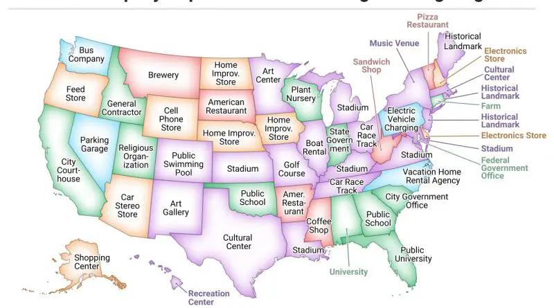
Thanksgiving search trends reflect the unique blend of cultural traditions, regional preferences, and individual interests that make each state in the U.S. distinct.
Read More
Billionaires shape industries and economies worldwide, but where are they most concentrated? This article explores the geography of wealth, from the countries with the most billionaires to cities attracting the ultra-rich. With data-driven insights and maps, we uncover the shifting landscape of global wealth.
Read More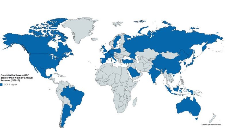
Walmart Inc. is an American multinational retail corporation that operates a chain of hypermarkets, discount department stores, and grocery stores. It was founded by Sam Walton in 1962 and is headquartered in Bentonville, Arkansas. Walmart is one of the world’s largest companies by revenue and employs over 2.3 million associates worldwide.
Read More
Crime rates in the U.S. have changed over time, with rapid growth after 1900, reaching a sizeable bulging top within the 1970s and early 1990s. Since then, crime has decreased significantly. In 2018, the murder rate in the United States was 5 per 100 thousand, for a sum of 15.5 thousand murders.
Read More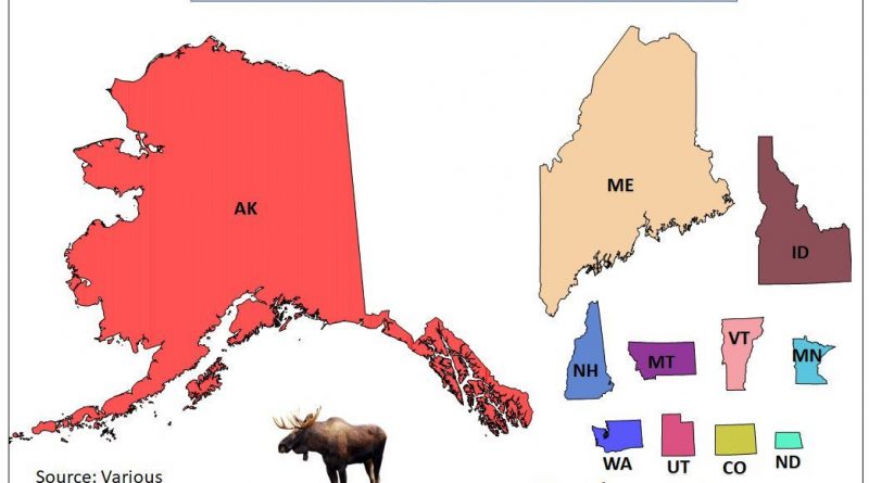
Moose populate boreal, mixed, and temperate broadleaf forests. In North America, the moose range covers all of Canada and Alaska, north of New England and upstate New York, the upper Rocky Mountains, northern Minnesota, north of Wisconsin, Michigan’s Upper Peninsula, and Isle Royale. The North American moose population is about 1 million animals.
Read More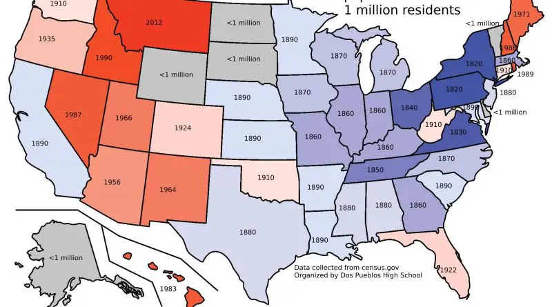
The population of the United States has experienced significant growth throughout its history. In the 1790 census, the population was around 3.9 million. By 1860, it had grown to approximately 31.4 million, largely due to natural increase and immigration.
Read More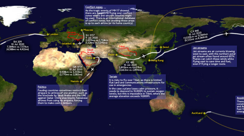
The shortest distance between two points is a straight line, right? Not when you’re flying. The flight from London to Auckland covers 18,336 kilometers, and the route from London to Dunedin spans 19,086 kilometers. On a map, you can see the most direct paths, but commercial planes rarely take them. Seven different factors push aircraft off their ideal routes, adding time, burning extra fuel, and ultimately raising ticket prices for passengers.
Read More
Viral videos are videos that quickly spread across the internet, gaining widespread attention and often millions of views in a short period. The content of viral videos can vary widely, from humorous clips to heartwarming stories, from shocking events to informative content.
Read More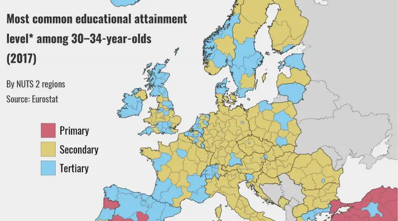
Across various age groups in Europe, the most common educational attainment level exhibits nuanced patterns reflective of societal, economic, and historical factors.
Read More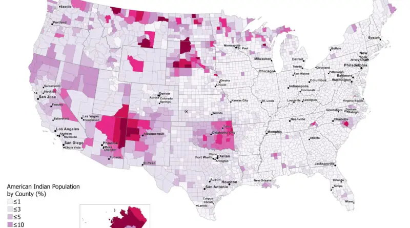
The American Indian population, also known as Native Americans or indigenous peoples of the Americas, comprises a diverse group of ethnicities, cultures, and languages. They are the descendants of the original inhabitants of the Americas before European colonization. The ancestors of modern American Indians arrived in America at least 15 thousand years ago from Asia. Historically, the country’s indigenous people had a population of nearly 10 million before European settlers explored America.
Read More