Skip to content
Vivid Maps Logo

  • Atlases
  • Map Posters
  • Scratch Maps
  • Globes
  • Videos
Modern Canada Climate Map
ClimateClimate ChangeNewsVivid maps
October 17, 2025 Alex

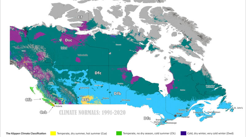
Canada’s Shifting Climate Zones: Köppen-Geiger Maps from 1930 to 2099

Köppen-Geiger climate maps of Canada reveal dramatic northward shifts from 1901-1930 to 2077-2099. Animated comparisons show tundra retreating to Arctic islands, subarctic zones moving hundreds of kilometers north, tree line advancing, and southern continental climates warming under the ssp2-4.5 scenario.

Read More
Oceania with Exclusive Economic Zones
Economic mapsPolitical maps
October 17, 2025 Alex

The Ocean Nations of Oceania

A political map of Oceania shows the region’s vast Exclusive Economic Zones, where small island states like French Polynesia, Micronesia, and the Marshall Islands control huge ocean territories.

Read More
United States Köppen Climate Classification Map
ClimateClimate ChangeNewsVivid maps
October 14, 2025 Alex

How America’s Climate Zones Are Shifting

New Köppen-Geiger climate maps of the United States reveal dramatic shifts from 1901-1930 to 2077-2099. Watch animated comparisons showing how tundra retreats in Alaska, continental zones move north, and arid regions expand in the West under the ssp2-4.5 climate scenario.

Read More
The actual size of Hawaii mapped
Size comparison maps
October 12, 2025 Alex

The True Extent of the Hawaiian Archipelago

The Hawaiian archipelago stretches 2,450 km (1,520 mi) across the Pacific, encompassing 137 named islands from the Big Island to remote Kure Atoll. That’s roughly the distance from New York to Denver, yet often compressed on standard maps.

Read More
Mobilization Reserve in Case of War mapped
NewsPolitical mapsVivid maps
October 9, 2025 Alex

Mobilization Reserves vs Willingness to Fight Across Europe

Russia leads Europe with 38.2 million men aged 18-59 in mobilization reserve, but survey data shows only 84% would actually fight. Belgium has the lowest willingness at 19%, while Norway tops the chart at 92%.

Read More
Share of 15-19 years old with two native born parents mapped
DemographyImmigration
October 8, 2025 Alex

Where Europe’s 15–19-Year-Olds Have Two Native-Born Parents

The Eurostat-based map highlights how migration has reshaped Europe’s families. Many Central and Eastern European countries still have over 90% of teens with two native-born parents, while Western and Northern nations show far lower shares due to long histories of immigration and mobility.

Read More
Map of the Five Guianas
Political maps
October 5, 2025 Alex

The Five Guianas

The Five Guianas: Spanish, British, Dutch, French and Portuguese claims along northeast South America — how those colonial names became today’s regions.

Read More
Counties that used to be part of Mexico mapped
Historical Maps
September 26, 2025 Alex

447 U.S. Counties That Used to Be Mexico

Most people know California and Texas used to be Mexico. But did you know half of Colorado was too? Nevada, Arizona, New Mexico, and Utah were completely Mexican. Even bits of Wyoming, Kansas, and Oklahoma. This map shows all 447 counties that became American in the 1840s and 1850s.

Read More
Mediterranean biomes mapped
Climate Change
September 21, 2025 Alex

Mediterranean Biomes Around the World

People often prefer Mediterranean climates for their gentle seasons and reliable weather. From the Mediterranean Basin to California, central Chile, South Africa’s fynbos and Australia’s mallee, the same seasonal pattern gives rise to distinctive shrublands and woodlands.

Read More
How college educated women voted in 2024 mapped
Political maps
September 20, 2025 Alex

2024 United States Presidential Election by Gender and Education

Four maps breaking down the 2024 election by education and gender show how dramatically voting patterns differ across America. College-educated women favored Harris 61-37%, while college-educated men split more evenly at 51-47% for Harris. Non-college women went narrowly for Trump 52-46%, but non-college men backed Trump decisively at 61-37%.

Read More
Page 1 of 67512345...102030...»Last »

Trending now

  • The Price of Sex around the World Mapped
  • Koppen-Geiger climate classification (Hi-res world map)
    World Map of Köppen-Geiger Climate Classification

Related Products

Push pin maps · Globe drinks cabinets · Maps of the United States · Board games · Monopoly · Map-based strategy board games · History Board Games · Coloring Books · Handheld GPS · GPS Watches · GPS Trackers

Vivid Maps Tools

· Convert Latitude/Longitude
· Elevation Finder
· Distance Calculator
· Kilometers to Miles Converter
· Kilograms to Pounds Converter
· Liters to Gallons Converter
· Temperature Converter
· Find cities with a similar climate
· Find cities with a similar climate (2050)
· How hot cities could be in 2050
· The U.S. Population Lines

About
Privacy Policy

Copyright © 2025 Vivid Maps. All rights reserved.