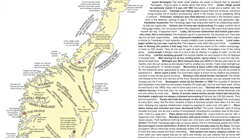
Skip to content
Vivid Maps Logo

  • Atlases
  • Map Posters
  • Scratch Maps
  • Globes
  • Videos
World
November 7, 2017 Alex

Most deadly month by U.S. state

Source: metricmaps.org Winter is the most deadly season in the United States. January is the most deadly month in the

Read More
Animated mapsMaps of World ReligionsSliderVivid maps
November 7, 2017 Alex

Evangelical protestant population (1936 – 2010)

Evangelical protestant population

Read More
Economic maps
November 7, 2017 Alex

European countries poorer and richer than Turkey (October 2017)

Reddit user: donuboklumuharrem Most countries of Eastern Europe, with the exception of Russia, Latvia, Lithuania, and Estonia, are poorer than Turkey.

Read More
Historical Maps
November 5, 2017 Alex

All countries invaded by France

The First French colonial empire stretched from a total area at its peak in 1680 to over 10 million square kilometers (3.9 million sq mi). The Second French colonial empire stretched to over 13.5 million square kilometers (5.2 million sq mi) at its peak in 1936.

Read More
Economic mapsTransport
November 5, 2017 Alex

San Francisco Bay Area approximate median household income by BART Stop

BART (Bay Area Rapid Transit), is a rapid transit public transportation system serving the San Francisco Bay Area in California.

Read More
ForestsWorld
November 4, 2017 Alex

% of forests by land area in the world

Reddit user: MagicGnomeS 20 countries with largest forest area (% of land area): #1 Suriname – 98.3%#2 Micronesia – 91.8%#3

Read More
Voting rights in Europe
LawsPolitical maps
November 4, 2017 Alex

The year women gained the right to vote in Europe

Starting in the mid-19th-century, women tried to alter voting legislation to permit them to vote. The first county in the world to award and maintain women’s suffrage continuously was Norway in 1913.

Read More
CitiesEconomic mapsInfographics
November 4, 2017 Alex

31 Chinese cities with economies as big as countries

Each of the 31 Chinese cities below has a GDP that is equivalent an entire country. www.visualcapitalist.com Chinese cities compared

Read More
World
November 3, 2017 Alex

Moral and Political Chart of the Inhabited World (1837)

Exhibiting the prevailing religion, a form of government, a degree of civilization and population of each country. Source: martingrandjean.ch

Read More
World
November 3, 2017 Alex

10 of the world’s shortest borders

Separation sections of international land or river borders, unconnected by territorial waters, clusters of exclaves are represented by their smallest

Read More
Page 130 of 675« First«...102030...128129130131132...140150160...»Last »

Trending now

  • The Price of Sex around the World Mapped
  • The most used Emoji in every country
    The Most Used Emoji on Twitter in Every Country Mapped

Related Products

Push pin maps · Globe drinks cabinets · Maps of the United States · Board games · Monopoly · Map-based strategy board games · History Board Games · Coloring Books · Handheld GPS · GPS Watches · GPS Trackers

Vivid Maps Tools

· Convert Latitude/Longitude
· Elevation Finder
· Distance Calculator
· Kilometers to Miles Converter
· Kilograms to Pounds Converter
· Liters to Gallons Converter
· Temperature Converter
· Find cities with a similar climate
· Find cities with a similar climate (2050)
· How hot cities could be in 2050
· The U.S. Population Lines

About
Privacy Policy

Copyright © 2025 Vivid Maps. All rights reserved.