Skip to content
VividMaps

  • Atlases
  • Map Posters
  • Scratch Maps
  • Globes
  • Videos
CitiesEnvironment mapsInteractive maps
January 4, 2017 Alex

Treepedia: Mapping Urban Trees in U.S. Cities

Understanding and promoting urban tree cover has never been more important Increasing a city’s tree canopy contributes to lowering urban

Read more: Treepedia: Mapping Urban Trees in U.S. Cities →

BusinessWorld
January 4, 2017 Alex

The nearest places in a straight line from Ireland

Read more: The nearest places in a straight line from Ireland →
Mapping StereotypesTerrorismTransport
January 4, 2017 Alex

Train prices across Europe

UK train prices highest in Europe (based on price per mile, 50 miles from capital city) Source: www.vouchercloud.com

Read more: Train prices across Europe →
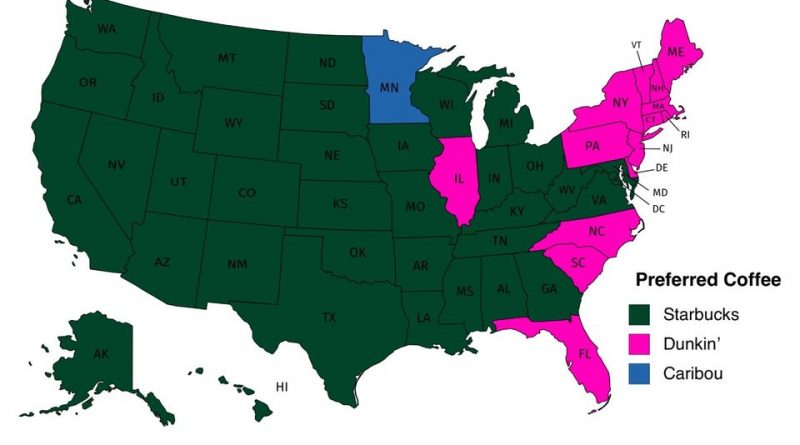
The most common coffee chain in the United States
Food
January 4, 2017 Alex

The most common coffee chain and the number of coffee shops per 100,000 in each U.S. state

Which coffee shops has the most locations per U.S. state Starbucks is the most popular coffeehouse in the United States.

Read more: The most common coffee chain and the number of coffee shops per 100,000 in each U.S. state →
ClimateVideo
January 3, 2017 Alex

One year time lapse of total precipitable water (2016)

One year time lapse of precipitable water from Jan 1, 2016 to Dec 31, 2016, as modeled by the Global

Read more: One year time lapse of total precipitable water (2016) →
Interactive mapsReal-Time MapsTraffic Map
January 3, 2017 Alex

NYC Real-Time Traffic Map

Related posts: – New York’s Subway Deserts – New York City boroughs journey to work-driving ca alone vs. walk/public transportation

Read more: NYC Real-Time Traffic Map →

GoogleNatural disasters
January 2, 2017 Alex

Annual amount of thunderstorms in the US

Read more: Annual amount of thunderstorms in the US →
Entertainment
January 1, 2017 Alex

First result after typing “[Country] Girl” into Image search

Read more: First result after typing “[Country] Girl” into Image search →
AgricultureInternetTravel
January 1, 2017 Alex

Mean farm size across world

Smallholder farming is the most prevalent form of agriculture in the world, supports many of the planet’s most vulnerable populations,

Read more: Mean farm size across world →
BusinessEconomic maps
January 1, 2017 Alex

The biggest bank from every U.S. state

Via businessinsider.com Related post: – Most popular bank in each State

Read more: The biggest bank from every U.S. state →
Mapping Health
December 31, 2016 Alex

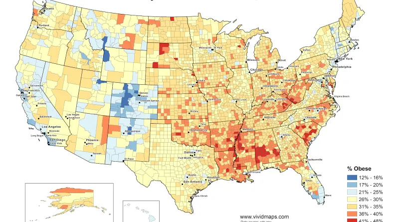
Physical inactivity in the U.S.

This map correlate with the obesity map.  Related post: – Obesity prevalence in the United States (2004 – 2013)

Read more: Physical inactivity in the U.S. →
Mapping StereotypesReal estate
December 31, 2016 Alex

Europe According to the Dutch

The Dutch stereotype map of Europe. Victor Van www.werkhooven.nl

Read more: Europe According to the Dutch →
Economic maps
December 31, 2016 Alex

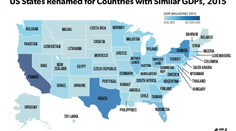
U.S. State borders redrawn & renamed for countries with similar GDPs

Read more: U.S. State borders redrawn & renamed for countries with similar GDPs →
Page 200 of 521« First«...196197198199200201202203204...»Last »

Trending now

  • Soviet detailed map
    Detailed Cold War-era Soviet military map of the San Francisco Bay area (1980)Oct 22, 2017
  • World map of Y-DNA Haplogroups
    World map of Y-DNA HaplogroupsMay 17, 2017
  • Maps of differences between East and West Germany
    Germany is still divided by east and westSep 11, 2020

Related Products

  • Push pin maps
  • Globe drinks cabinets
  • Maps of the United States
  • Board games
  • Monopoly
  • Map-based strategy board games
  • History Board Games
  • Coloring Books
  • Handheld GPS
  • GPS Watches
  • GPS Trackers

Vivid Maps Tools

  • Convert Latitude/Longitude
  • Elevation Finder
  • Distance Calculator
  • Kilometers to Miles Distance & Length Converter
  • Weight Converter
  • Volume Converter
  • Daylight Comparison
  • Time Zone Converter
  • Antipodes Map
  • Find cities with a similar climate
  • Find cities with a similar climate (2050)
  • How hot cities could be in 2050
  • The U.S. Population Lines

Stay connected

Get the latest maps, insights and updates delivered to your inbox.

Unsubscribe anytime.

VividMaps

Maps that explain the world.

Beautiful, data-rich maps to help you understand our world — its people, places and connections.

Explore

World map World atlas Map posters Globes

Company

About Privacy Contact

Stay connected

Follow us for the latest maps, insights and updates.

Independent WebsiteVirusScanner trust report for vividmaps.com
© 2026 Vivid Maps. All rights reserved.
A more connected world