
Skip to content
VividMaps

  • Atlases
  • Map Posters
  • Scratch Maps
  • Globes
  • Videos
Environment maps
January 10, 2017 Alex

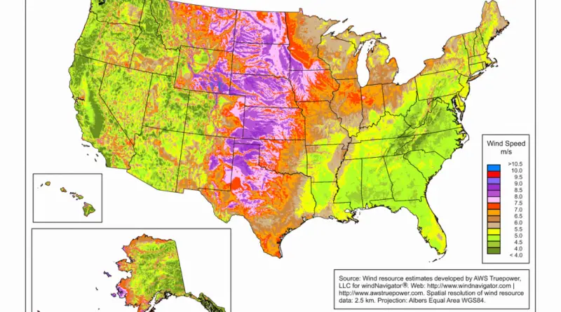
Wind Speed Map for the U.S.

Read more: Wind Speed Map for the U.S. →
3D mapsInteractive mapsMapping Stereotypes
January 9, 2017 Alex

Vancouver 3D Building Heights Map

Where are the tallest buildings in Vancouver? Where are the towers with podiums, or the walk-up apartment buildings, or the

Read more: Vancouver 3D Building Heights Map →
Economic mapsMapping Stereotypes
January 9, 2017 Alex

Number of U.S. counties with high levels of inequality & poverty has increased over time

In 1989, 11 percent of large metropolitan counties suffered from high levels of inequality, In 2014 – 21 percent. The

Read more: Number of U.S. counties with high levels of inequality & poverty has increased over time →
Cultural cartographyPolitical maps
January 9, 2017 Alex

American nations

The July 4, America celebrates independence from Great Britain. During that time, the United States was split into 13 separate colonies, which later developed and extended into the 50 U.S. states we have nowadays. But America isn’t only made up of 50 states. It may also be a nation composed of many tribes. This can be used as a basis for the cultural divisions of America into regions.

Read more: American nations →
Environment mapsGermanySlider
January 7, 2017 Alex

Light pollution map of Germany

Via zeit.de

Read more: Light pollution map of Germany →
GermanyLanguages
January 7, 2017 Alex

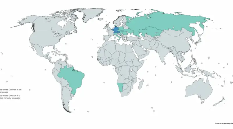
Countries where German is an official recognized minority language

Read more: Countries where German is an official recognized minority language →
Isochrone mapsMapping StereotypesTransportVideo
January 7, 2017 Alex

South Africa drive time map

Travel time to Johannesburg by car and scheduled flight.

Read more: South Africa drive time map →
Climate Change
January 7, 2017 Alex

Glaciers in Alaska’s National Parks

Glaciers are a central component of the visitor experience in Alaska. Most of Alaska’s glacier- covered area lies within national

Read more: Glaciers in Alaska’s National Parks →
TransportTravel
January 6, 2017 Alex

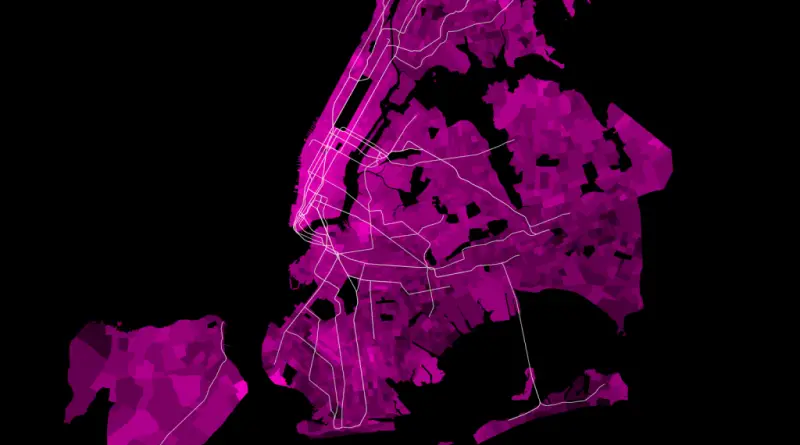
NYC average work commute times

Average Work Commute Times for New York City Residents. Via www.nickusoff.com   Related posts:  – New York’s Subway Deserts –

Read more: NYC average work commute times →
Transport
January 6, 2017 Alex

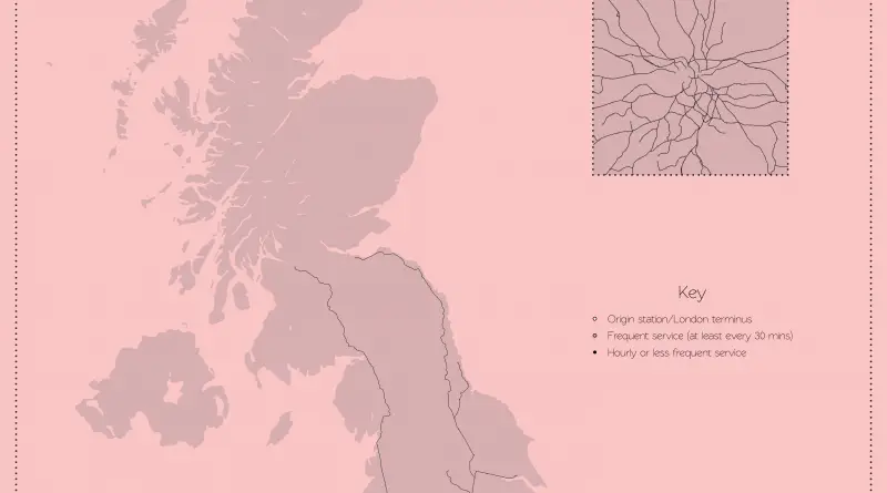
Mapping London’s reach

A map exploring an hour of train departures from London. Via helenlouiseatkinson.com Related posts: – London’s Tube Heartbeat – Visualizing

Read more: Mapping London’s reach →
CartogramsEconomic mapsInteractive mapsWarsWorld
January 5, 2017 Alex

Map of world billionaires by country & origin

Read more: Map of world billionaires by country & origin →
Median Age by U.S. State mapped
Demography
January 4, 2017 Alex

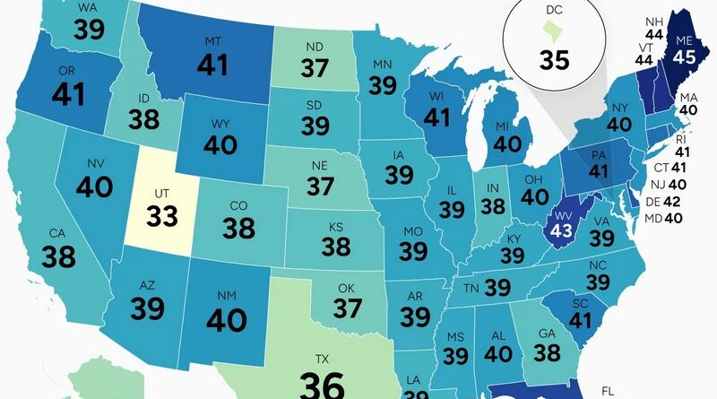
Mapped: U.S. Median Age by State

Maine and Utah are separated by 12 years in median age. Since 2000, New Hampshire added 6.5 years while North Dakota added barely half a year. Where young people choose to live makes all the difference.

Read more: Mapped: U.S. Median Age by State →
Environment mapsVideo
January 4, 2017 Alex

Pipeline Spills in the U.S. (1986 – 2016)

In the last 30 years, there have been over 8,700 liquid pipeline spills in the Unites States (nearly one every

Read more: Pipeline Spills in the U.S. (1986 – 2016) →
Page 199 of 521« First«...195196197198199200201202203...»Last »

Trending now

  • Soviet detailed map
    Detailed Cold War-era Soviet military map of the San Francisco Bay area (1980)Oct 22, 2017
  • World map of Y-DNA Haplogroups
    World map of Y-DNA HaplogroupsMay 17, 2017
  • Maps of differences between East and West Germany
    Germany is still divided by east and westSep 11, 2020

Related Products

  • Push pin maps
  • Globe drinks cabinets
  • Maps of the United States
  • Board games
  • Monopoly
  • Map-based strategy board games
  • History Board Games
  • Coloring Books
  • Handheld GPS
  • GPS Watches
  • GPS Trackers

Vivid Maps Tools

  • Convert Latitude/Longitude
  • Elevation Finder
  • Distance Calculator
  • Kilometers to Miles Distance & Length Converter
  • Weight Converter
  • Volume Converter
  • Daylight Comparison
  • Time Zone Converter
  • Antipodes Map
  • Find cities with a similar climate
  • Find cities with a similar climate (2050)
  • How hot cities could be in 2050
  • The U.S. Population Lines

Stay connected

Get the latest maps, insights and updates delivered to your inbox.

Unsubscribe anytime.

VividMaps

Maps that explain the world.

Beautiful, data-rich maps to help you understand our world — its people, places and connections.

Explore

World map World atlas Map posters Globes

Company

About Privacy Contact

Stay connected

Follow us for the latest maps, insights and updates.

Independent WebsiteVirusScanner trust report for vividmaps.com
© 2026 Vivid Maps. All rights reserved.
A more connected world