Skip to content
VividMaps

  • Atlases
  • Map Posters
  • Scratch Maps
  • Globes
  • Videos
ForecastsMappingWeather
December 31, 2016 Alex

Mapping floods in the U.S.

30 years of major flooding in the United States Climate scientists say extreme flooding events will become more common as

Read more: Mapping floods in the U.S. →

CitiesInteractive mapsReal estate
December 30, 2016 Alex

The Atlas of ReUrbanism

    The Atlas of ReUrbanism is a tool to understand, support, and transform American cities. Developed by the Preservation Green

Read more: The Atlas of ReUrbanism →
Environment maps
December 30, 2016 Alex

Car accidents caused by animals in Victoria (Australia)

Last year more than 75,000 motorists lodged a claim with the Royal Automobile Club of Victoria (RACV) over car damage,

Read more: Car accidents caused by animals in Victoria (Australia) →
Crime maps
December 29, 2016 Alex

The Most and Least Dangerous Counties in the U.S.

The crime rate combines recorded occurrences of violent and property crime, particularly aggravated assault, arson, burglary, larceny, murder, rape, robbery,

Read more: The Most and Least Dangerous Counties in the U.S. →
Animated mapsBusinessEnvironment mapsWorld
December 29, 2016 Alex

Change in forest cover (1990 – 2015)

Read more: Change in forest cover (1990 – 2015) →
Germany
December 29, 2016 Alex

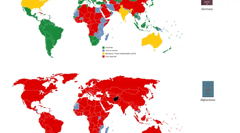
German passport vs. Afghan passport

Read more: German passport vs. Afghan passport →
BusinessMapping StereotypesOld maps
December 29, 2016 Alex

Population Density map of the Soviet Union (1929)

Read more: Population Density map of the Soviet Union (1929) →
MapsOil
December 29, 2016 Alex

Fuel Oil Consumption by Country

Fuel oil is a fraction obtained from petroleum distillation, either as a distillate or a residue. Broadly speaking, fuel oil

Read more: Fuel Oil Consumption by Country →
Cultural cartographyMapping Stereotypes
December 27, 2016 Alex

Estimated Prevalence of Female Genital Mutilation in Africa

Source: Wikipedia.org

Read more: Estimated Prevalence of Female Genital Mutilation in Africa →
Economic mapsJob
December 27, 2016 Alex

Unemployment in the contiguous U.S.

Read more: Unemployment in the contiguous U.S. →
DemographyMapping StereotypesPopulationVideoWorld
December 27, 2016 Alex

Evolution of the French population in each departement (1931 – 2013)

Reddit user: gabechko Related post:  – Largest foreign-born population in each French department by country of birth

Read more: Evolution of the French population in each departement (1931 – 2013) →
Maps of World Religions
December 26, 2016 Alex

Mapping religion in the United States

Approximately 70 percent of Americans who are religious are of the Christian faith. Christian congregations Source: www.ocregister.com Non-Christian congregations Source:

Read more: Mapping religion in the United States →
Historical Maps
December 25, 2016 Alex

Territorial evolution of Germany

The territorial evolution of Germany is characterized by significant changes over centuries. Modern Germany has seen the consolidation of various smaller states into a unified nation. It began with the Holy Roman Empire and then experienced fragmentation during the Middle Ages. The 19th century marked the gradual formation of a unified German state.

Read more: Territorial evolution of Germany →
Page 201 of 521« First«...197198199200201202203204205...»Last »

Trending now

  • Soviet detailed map
    Detailed Cold War-era Soviet military map of the San Francisco Bay area (1980)Oct 22, 2017
  • World map of Y-DNA Haplogroups
    World map of Y-DNA HaplogroupsMay 17, 2017
  • Maps of differences between East and West Germany
    Germany is still divided by east and westSep 11, 2020

Related Products

  • Push pin maps
  • Globe drinks cabinets
  • Maps of the United States
  • Board games
  • Monopoly
  • Map-based strategy board games
  • History Board Games
  • Coloring Books
  • Handheld GPS
  • GPS Watches
  • GPS Trackers

Vivid Maps Tools

  • Convert Latitude/Longitude
  • Elevation Finder
  • Distance Calculator
  • Kilometers to Miles Distance & Length Converter
  • Weight Converter
  • Volume Converter
  • Daylight Comparison
  • Time Zone Converter
  • Antipodes Map
  • Find cities with a similar climate
  • Find cities with a similar climate (2050)
  • How hot cities could be in 2050
  • The U.S. Population Lines

Stay connected

Get the latest maps, insights and updates delivered to your inbox.

Unsubscribe anytime.

VividMaps

Maps that explain the world.

Beautiful, data-rich maps to help you understand our world — its people, places and connections.

Explore

World map World atlas Map posters Globes

Company

About Privacy Contact

Stay connected

Follow us for the latest maps, insights and updates.

Independent WebsiteVirusScanner trust report for vividmaps.com
© 2026 Vivid Maps. All rights reserved.
A more connected world