Skip to content
VividMaps

  • Atlases
  • Map Posters
  • Scratch Maps
  • Globes
  • Videos
Economic maps
November 27, 2016 Alex

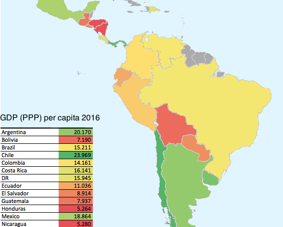
Latin American Countries by GDP (PPP) per capita (2016)

Reddit user: nahuelacevedopena

Read more: Latin American Countries by GDP (PPP) per capita (2016) →

Cultural cartographyInteractive mapsMapping StereotypesWorld
November 27, 2016 Alex

The World song map

https://www.wired.com/2016/11/every-single-name-entrancing-map-music-reference/ Via wired.com

Read more: The World song map →
CitiesGermany
November 27, 2016 Alex

German city names in the United States

Via zeit.de

Read more: German city names in the United States →
GoogleTourism
November 27, 2016 Alex

“What to see in…” autocompleted by Google for each country on this map

Every country’s most popular tourist attraction. “What to see in…” Albania – Albanian Riviera Algeria – Notre Dame d’Afrique Azerbaijan

Read more: “What to see in…” autocompleted by Google for each country on this map →
Ethnic maps
November 26, 2016 Alex

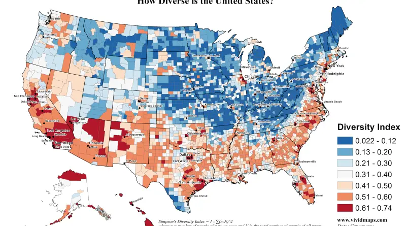
The increasingly diverse United States of America

How Diverse is the U.S.?  Via vividmaps.com County-level change in diversity since 2000  Via washingtonpost.com

Read more: The increasingly diverse United States of America →
World
November 26, 2016 Alex

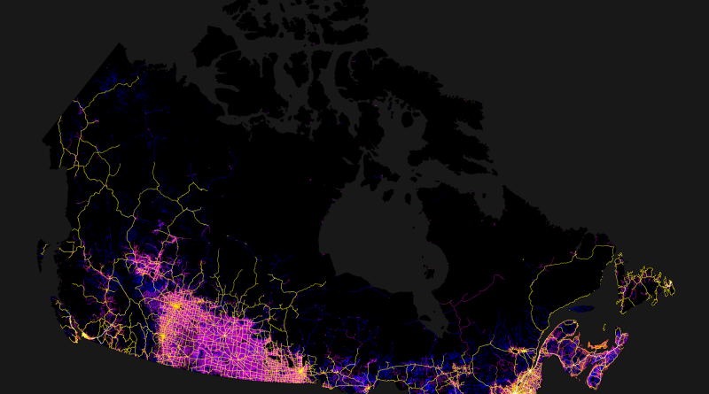
2,500 kilometer-long line that stretches halfway cross Canada without seeing virtually any signs of humanity

You could walk the entirety of this 2,500 kilometer-long line that stretches halfway cross Canada without seeing virtually any signs

Read more: 2,500 kilometer-long line that stretches halfway cross Canada without seeing virtually any signs of humanity →
BusinessHistorical MapsInteractive mapsMaps of World Religions
November 26, 2016 Alex

A map of the world at the height of the Caliphate (750 A.D.)

Read more: A map of the world at the height of the Caliphate (750 A.D.) →
Transport
November 26, 2016 Alex

Public transportation map of Tokyo

The public transportation network in Greater Tokyo includes rail and highway networks, airports, buses, walking, and bicycling. The transportation network makes the sprawling city easily accessible and provides the Japanese to commute to Tokyo from other prefectures.

Read more: Public transportation map of Tokyo →
InternetWorld
November 26, 2016 Alex

Geography of unsecured Wi-Fi Access points

Read more: Geography of unsecured Wi-Fi Access points →
GoogleInternetMapping StereotypesPopulation
November 26, 2016 Alex

“What to see in…” autocompleted by Google for each country on this map

Read more: “What to see in…” autocompleted by Google for each country on this map →
Mapping Stereotypes
November 26, 2016 Alex

Toponymic Fantasy Map of Texas

Read more: Toponymic Fantasy Map of Texas →
Animated mapsMetro mapsPolitical maps
November 26, 2016 Alex

Change in margin between 2004 & 2016 elections

Related posts: – The power of small U.S. states – 3D map of county-level election results – Geographically approximate, population-normalized

Read more: Change in margin between 2004 & 2016 elections →
Languages
November 26, 2016 Alex

States and Union Territories of India by the Most Commonly Spoken First Language

Read more: States and Union Territories of India by the Most Commonly Spoken First Language →
Page 210 of 521« First«...206207208209210211212213214...»Last »

Trending now

  • Soviet detailed map
    Detailed Cold War-era Soviet military map of the San Francisco Bay area (1980)Oct 22, 2017
  • World map of Y-DNA Haplogroups
    World map of Y-DNA HaplogroupsMay 17, 2017
  • World Map of the Most Uniquely Popular Word On Every County's Wikipedia Page
    The Most Uniquely Popular Word on Each Country’s Wikipedia Page MappedDec 1, 2022

Related Products

  • Push pin maps
  • Globe drinks cabinets
  • Maps of the United States
  • Board games
  • Monopoly
  • Map-based strategy board games
  • History Board Games
  • Coloring Books
  • Handheld GPS
  • GPS Watches
  • GPS Trackers

Vivid Maps Tools

  • Convert Latitude/Longitude
  • Elevation Finder
  • Distance Calculator
  • Kilometers to Miles Distance & Length Converter
  • Weight Converter
  • Volume Converter
  • Daylight Comparison
  • Time Zone Converter
  • Antipodes Map
  • Find cities with a similar climate
  • Find cities with a similar climate (2050)
  • How hot cities could be in 2050
  • The U.S. Population Lines

Stay connected

Get the latest maps, insights and updates delivered to your inbox.

Unsubscribe anytime.

VividMaps

Maps that explain the world.

Beautiful, data-rich maps to help you understand our world — its people, places and connections.

Explore

World map World atlas Map posters Globes

Company

About Privacy Contact

Stay connected

Follow us for the latest maps, insights and updates.

Independent WebsiteVirusScanner trust report for vividmaps.com
© 2026 Vivid Maps. All rights reserved.
A more connected world