Skip to content
VividMaps

  • Atlases
  • Map Posters
  • Scratch Maps
  • Globes
  • Videos
DemographyPopulation
December 5, 2016 Alex

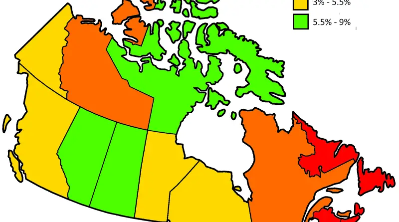
Canadian provinces population growth (2012 – 2016)

Reddit user: BuddyWudd

Read more: Canadian provinces population growth (2012 – 2016) →

ScienceSliderVideo
December 5, 2016 Alex

Permanent research stations in Antarctica

Read more: Permanent research stations in Antarctica →
Population
December 5, 2016 Alex

Population density of Austria

Read more: Population density of Austria →
Ethnic mapsMapping StereotypesMaps of World ReligionsOld mapsSlider
December 3, 2016 Alex

Map of the races of Europe (1919)

Read more: Map of the races of Europe (1919) →
EducationMaps of World Religions
December 3, 2016 Alex

Average number of foreign languages studied per pupil in lower & general upper secondary education

Average number of foreign languages studied per pupil in lower secondary education Average number of foreign languages studied per pupil

Read more: Average number of foreign languages studied per pupil in lower & general upper secondary education →
World
December 3, 2016 Alex

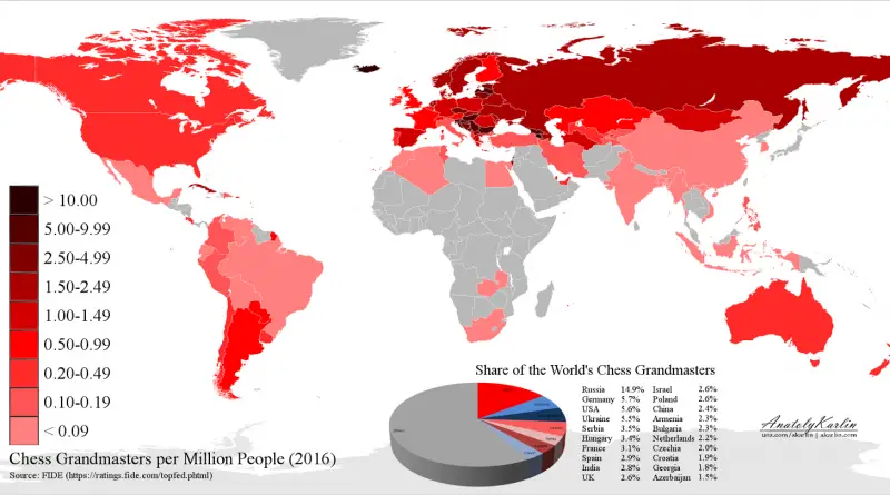
World Map of Chess Grandmasters (2016)

Read more: World Map of Chess Grandmasters (2016) →
World
December 3, 2016 Alex

The most popular street names in each U.S. state

Overall in the nation, Park is the most popular street name. But Dogwood and Magnolia reign in the South, while

Read more: The most popular street names in each U.S. state →
InternetMapping StereotypesOld mapsPopulation
December 3, 2016 Alex

Map of the world according to Anaximander (6th century BC)

Reddit user: AJgloe

Read more: Map of the world according to Anaximander (6th century BC) →
Ethnic mapsOld maps
December 3, 2016 Alex

Slave population of the southern states of the U.S.

“Map showing the distribution of the slave population of the Southern States of the United States. Compiled from the Census

Read more: Slave population of the southern states of the U.S. →
Animated mapsEducationMapping Stereotypes
December 2, 2016 Alex

The surprising countries directly across the sea from Great Britain

Via telegraph.co.uk

Read more: The surprising countries directly across the sea from Great Britain →
Economic maps
December 2, 2016 Alex

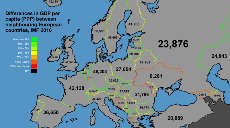
Differences in GDP per capita between neighbouring European countries

Read more: Differences in GDP per capita between neighbouring European countries →
LanguagesMapping StereotypesWorld
December 2, 2016 Alex

First language of white South Africans

Read more: First language of white South Africans →
Transport
December 2, 2016 Alex

6 maps that show the anatomy of America’s infrastructure

Maritime traffic in and around the US Airports Bridges The electric grid Pipelines Railroads Via washingtonpost.com Related post: – An

Read more: 6 maps that show the anatomy of America’s infrastructure →
Page 208 of 521« First«...204205206207208209210211212...»Last »

Trending now

  • Soviet detailed map
    Detailed Cold War-era Soviet military map of the San Francisco Bay area (1980)Oct 22, 2017
  • World map of Y-DNA Haplogroups
    World map of Y-DNA HaplogroupsMay 17, 2017
  • World Map of the Most Uniquely Popular Word On Every County's Wikipedia Page
    The Most Uniquely Popular Word on Each Country’s Wikipedia Page MappedDec 1, 2022

Related Products

  • Push pin maps
  • Globe drinks cabinets
  • Maps of the United States
  • Board games
  • Monopoly
  • Map-based strategy board games
  • History Board Games
  • Coloring Books
  • Handheld GPS
  • GPS Watches
  • GPS Trackers

Vivid Maps Tools

  • Convert Latitude/Longitude
  • Elevation Finder
  • Distance Calculator
  • Kilometers to Miles Distance & Length Converter
  • Weight Converter
  • Volume Converter
  • Daylight Comparison
  • Time Zone Converter
  • Antipodes Map
  • Find cities with a similar climate
  • Find cities with a similar climate (2050)
  • How hot cities could be in 2050
  • The U.S. Population Lines

Stay connected

Get the latest maps, insights and updates delivered to your inbox.

Unsubscribe anytime.

VividMaps

Maps that explain the world.

Beautiful, data-rich maps to help you understand our world — its people, places and connections.

Explore

World map World atlas Map posters Globes

Company

About Privacy Contact

Stay connected

Follow us for the latest maps, insights and updates.

Independent WebsiteVirusScanner trust report for vividmaps.com
© 2026 Vivid Maps. All rights reserved.
A more connected world