Morningside Heights Historic District Explorer
This 3D web map allows users to learn more about the Morningside Heights Historic District, which the New York City
Read MoreThis 3D web map allows users to learn more about the Morningside Heights Historic District, which the New York City
Read MoreThe EU budget is paid for by the 28 member countries, but some nations get more back from the EU
Read More
What each region of Russia dreams about the most, according to Yandex (the largest search engine in Russia). Via yandex.ru
Read MoreAfter years of decline, reports of anti-Semitic crimes began increasing in 2015, according to FBI data. Experts say the trends
Read More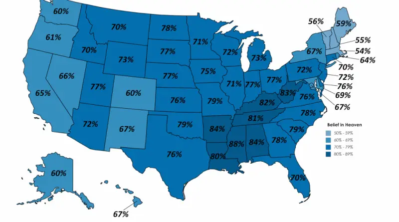
Belief in Heaven it the Unites States Belief in Hell in the United States Belief in GOD in the United
Read MoreSource: nw12398 The parties who won seats are as follows: VVD (Volkspartij voor Vrijheid and Democratie – People’s Party for
Read MoreThis analysis merges Census Bureau data with Google maps to provide a visual representation of immigration’s impact on public schools
Read MoreThis full-color travel map of Scotland, at 8.7 miles to 1 inch (1:550,000), covers the whole of Scotland and part
Read MoreSometimes finding a bike route can be as hard as biking up a hill. Mapzen’s new bike overlay for Walkabout
Read More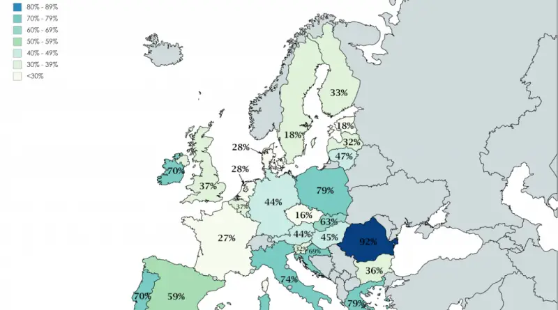
Americans are more religious than Europeans. About 61 percent of U.S. citizens state God is all-powerful, for example. In comparison, the median in some European countries like Sweden and Denmark on this question is just 13% of adults say this. 23% of the American adult population identify as religiously unaffiliated.
Read More