Skip to content
VividMaps

  • Atlases
  • Map Posters
  • Scratch Maps
  • Globes
  • Videos
Political mapsVideo
July 14, 2016 Alex

The 2016 Democratic and Republican Primaries: Every Day

The progress of the 2016 Democratic Primaries each day as well as the voting margins of every county that voted.

Read more: The 2016 Democratic and Republican Primaries: Every Day →

Cultural cartographyInteractive mapsTransport
July 14, 2016 Alex

Highways and Railroads of Australia as a Subway Maps

Highways of Australia mapped in the style of the London Subway Railroad map of Australia Related posts:– Railroads of Africa

Read more: Highways and Railroads of Australia as a Subway Maps →
Job
July 14, 2016 Alex

Most disproportionately well-paying job in each US state

Read more: Most disproportionately well-paying job in each US state →
Global WarmingHeat mapsHistorical MapsOld mapsWars
July 14, 2016 Alex

First World War Map from the Daily Mail (1914)

Read more: First World War Map from the Daily Mail (1914) →
Cartograms
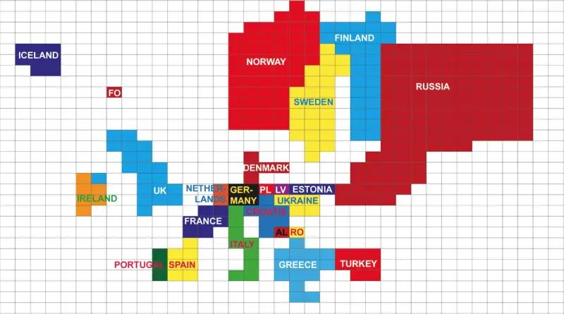
July 13, 2016 Alex

Europe adjusted for length of coastline

1 grid square = 1000 km (621 mi) coastline. Rounded to the nearest 1000. Less than 500 km not included.

Read more: Europe adjusted for length of coastline →
Economic mapsEnergyHumorInternet
July 13, 2016 Alex

Map of average U.S. residential electricity price by utility service territory

Read more: Map of average U.S. residential electricity price by utility service territory →
InternetMapping StereotypesTransportVideo
July 12, 2016 Alex

A day over the UK

This data visualisation shows the air traffic coming into, going out of and flying across the UK on a typical

Read more: A day over the UK →
Climate ChangeCrime mapsInteractive maps
July 12, 2016 Alex

CrimeTeller: Crime street view

Crime Teller provides a crime map at street level. It uses a new geographic information system (GIS) technology. You can

Read more: CrimeTeller: Crime street view →
Energy
July 12, 2016 Alex

Where did recent gas price declines affect consumers the most?

How falling gas prices fuel the consumer interactive map. Via JPMorgan Chase Institute

Read more: Where did recent gas price declines affect consumers the most? →
Mapping StereotypesWorld
July 12, 2016 Alex

What’s across the ocean?

Europe is not across the ocean from New York… but Australia is. By Max Galka via Metrocosm

Read more: What’s across the ocean? →
Economic maps
July 12, 2016 Alex

Chinese Investments in Africa since 2010

 Via Stratfor, 2012

Read more: Chinese Investments in Africa since 2010 →
Economic mapsInteractive mapsNews
July 12, 2016 Alex

Logistics Performance Index 2016

Based on a worldwide survey of global freight forwarders and express carriers, the Logistics Performance Index is an interactive benchmarking

Read more: Logistics Performance Index 2016 →
Ethnic mapsInteractive maps
July 12, 2016 Alex

Clan Map of Scotland

Map of the Southern and central portions of the ancient Scottish clan lands The lands colored for each name indicate

Read more: Clan Map of Scotland →
Page 262 of 521« First«...258259260261262263264265266...»Last »

Trending now

  • World Map of the Most Uniquely Popular Word On Every County's Wikipedia Page
    The Most Uniquely Popular Word on Each Country’s Wikipedia Page MappedDec 1, 2022
  • Steel production in 1800 mapped
    220 Years of Steel Production, Mapped From 1800 to 2025Oct 18, 2026
  • Largest Ancestry in the United States
    Largest Ancestry by U.S. CountyMar 23, 2019

Related Products

  • Push pin maps
  • Globe drinks cabinets
  • Maps of the United States
  • Board games
  • Monopoly
  • Map-based strategy board games
  • History Board Games
  • Coloring Books
  • Handheld GPS
  • GPS Watches
  • GPS Trackers

Vivid Maps Tools

  • Convert Latitude/Longitude
  • Elevation Finder
  • Distance Calculator
  • Kilometers to Miles Distance & Length Converter
  • Weight Converter
  • Volume Converter
  • Daylight Comparison
  • Time Zone Converter
  • Antipodes Map
  • Find cities with a similar climate
  • Find cities with a similar climate (2050)
  • How hot cities could be in 2050
  • The U.S. Population Lines

Stay connected

Get the latest maps, insights and updates delivered to your inbox.

Unsubscribe anytime.

VividMaps

Maps that explain the world.

Beautiful, data-rich maps to help you understand our world — its people, places and connections.

Explore

World map World atlas Map posters Globes

Company

About Privacy Contact

Stay connected

Follow us for the latest maps, insights and updates.

Independent WebsiteVirusScanner trust report for vividmaps.com
© 2026 Vivid Maps. All rights reserved.
A more connected world