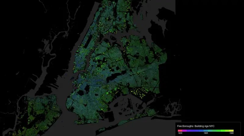
Skip to content
Vivid Maps Logo

  • Atlases
  • Map Posters
  • Scratch Maps
  • Globes
  • Videos
World map of countries based on share of immigrants
DemographyNewsVivid maps

Mapped: Countries With the Lowest Percentage of Immigrants

June 18, 2025 Alex
United States border elevation maped
Environment mapsNewsPolitical mapsVivid maps

United States Border Walls

May 21, 2025 Alex
Cash in the banks by U.S. state mapped
Economic mapsNewsVivid maps

States Where Americans Have the Most Cash in the Bank

May 5, 2025 Alex
Mapped: Which Countries Get the Most Paid Time Off Overall
Economic mapsJob

How Paid Vacation Varies Around the World

August 5, 2025 Alex
Countries wealthier than the global average mapped
Economic maps

Which Countries Are Wealthier Than the Global Average?

July 27, 2025 Alex
Siesta in world countries mapped
Cultural cartography

Siesta Nations: A Map of Midday Rest Traditions Around the World

July 19, 2025 Alex
Difference between male and female BMI by country mapped
Health

Who Has Higher BMI: Men or Women?

June 25, 2025 Alex
BusinessHistorical MapsInteractive mapsMaps of World Religions
November 26, 2016 Alex

A map of the world at the height of the Caliphate (750 A.D.)

Read More
Transport
November 26, 2016 Alex

Public transportation map of Tokyo

The public transportation network in Greater Tokyo includes rail and highway networks, airports, buses, walking, and bicycling. The transportation network makes the sprawling city easily accessible and provides the Japanese to commute to Tokyo from other prefectures.

Read More
InternetWorld
November 26, 2016 Alex

Geography of unsecured Wi-Fi Access points

Read More
GoogleInternetMapping StereotypesPopulation
November 26, 2016 Alex

“What to see in…” autocompleted by Google for each country on this map

Read More
Mapping Stereotypes
November 26, 2016 Alex

Toponymic Fantasy Map of Texas

Read More
Animated mapsMetro mapsPolitical maps
November 26, 2016 Alex

Change in margin between 2004 & 2016 elections

Related posts: – The power of small U.S. states – 3D map of county-level election results – Geographically approximate, population-normalized

Read More
Languages
November 26, 2016 Alex

States and Union Territories of India by the Most Commonly Spoken First Language

Read More
Languages
November 25, 2016 Alex

Percentage of pupils in general upper secondary education learning French

16.4 percent of Europeans are learning French.

Read More
Historical MapsMapping StereotypesVideo
November 25, 2016 Alex

European History (1150 – 1700): Every year

European History (1150 – 1453) European History (1453 – 1700)

Read More
CarsInteractive maps
November 25, 2016 Alex

Car accidents in Birmingham

This visualization is showing 28519 car accidents that happened in the city of Birmingham during last years. This data are

Read More
Page 264 of 672« First«...102030...262263264265266...270280290...»Last »

Trending now

  • How Buddhism Spread Across Asia: Trade, Teaching, and Time
  • Populated places in Arctic mapped
    Arctic Cities: Who Actually Lives Up There?

Related Products

Push pin maps · Globe drinks cabinets · Maps of the United States · Board games · Monopoly · Map-based strategy board games · History Board Games · Coloring Books · Handheld GPS · GPS Watches · GPS Trackers

Vivid Maps Tools

· Convert Latitude/Longitude
· Elevation Finder
· Distance Calculator
· Kilometers to Miles Converter
· Kilograms to Pounds Converter
· Liters to Gallons Converter
· Temperature Converter
· Find cities with a similar climate
· Find cities with a similar climate (2050)
· How hot cities could be in 2050
· The U.S. Population Lines

About
Privacy Policy

Copyright © 2025 Vivid Maps. All rights reserved.